New Zealand’s wettest and 4th-warmest July on record
|
Temperature |
It was New Zealand’s 4th-warmest July on record, with the nationwide average temperature 1.3°C above average. Well above average (>1.20°C above average) temperatures were observed in the majority of the North Island and many locations experienced a record or near-record warm July. In the South Island, temperatures were generally above average (0.51-1.20°C above average). Some areas along the West Coast experienced well above average temperatures. Pockets of near average temperatures (±0.50°C of average) were observed in Canterbury, Otago and Southland. |
|
Rainfall |
It was an extraordinarily wet month and nationally it was the wettest July on record. The vast majority of the country observed well above normal (>149% of normal) rainfall. The exceptions were coastal parts of Gisborne, Hawke’s Bay and northern Wairarapa which experienced below normal rainfall (50-79% of normal). Western Fiordland experienced near normal rainfall (80-119% of normal). |
|
Soil Moisture |
At the end of the month, soil moisture levels were near normal for the majority of the country. Above normal soil moisture was observed in coastal parts of Otago, Canterbury and Marlborough. |
Overview
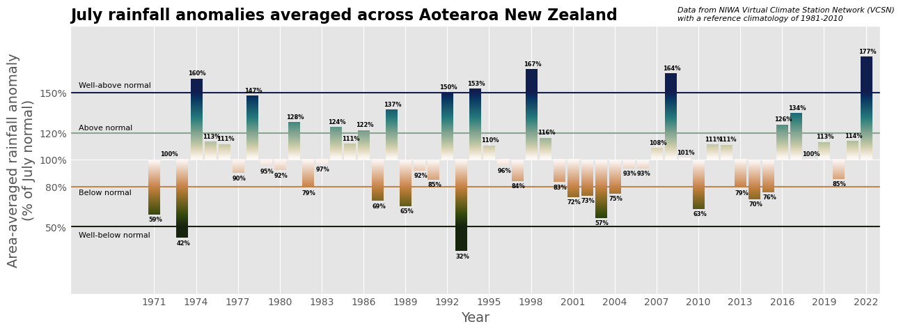
Record breaking rain, temperatures and wind were all part of the weather story for July 2022 in Aotearoa New Zealand. The rain was perhaps the most memorable feature of the month. From 11 July through to 31 July, five separate weather events brought flooding rain to the country (see Highlights and extreme events section). The culmination of these frequent rain events led to 20 locations experiencing their wettest July on record and near-record wet months for a further 25 locations. In Christchurch, it was the wettest month (of any month) on record. The 310 mm of rain recorded there was the first time that more than 300 mm of rain was observed in one month since records began in 1863. This represents around half of the rain that Christchurch typically receives over the course of one year. An analysis of rainfall anomalies from NIWA’s Virtual Climate Station Network (which extends back to 1971) shows that it was New Zealand’s wettest July on record (Figure 1).
July was also a warm month, particularly in the North Island where temperatures were well above average (>1.20°C above average) and many locations experienced record or near-record warmth. Frequent wet weather meant that it was a cloudy month and this was reflected in warmer than usual overnight temperatures with many locations in both the North and South Island experiencing record or near-record high mean minimum (overnight) temperatures. In the South Island, temperatures were generally above average (0.51-1.20°C above average). Some areas along the West Coast experienced well above average temperatures, while pockets of near average temperatures (±0.50°C of average) were observed in Canterbury, Otago and Southland. These were generally associated with areas that received frequent snowfall throughout the month. Some high elevation weather stations such as Mueller Hut (Aoraki/Mt Cook National park) in NIWA’s snow and ice network experienced snow depths during July that were the largest for the time of year since record keeping began in 2010. Overall, the nationwide average temperature in July 2022 was 9.1°C. This was 1.3°C above the 1981-2010 July average, making it New Zealand’s 4th-warmest July since NIWA’s seven station temperature series began in 1909.
There was a multitude of drivers behind the wet and warm weather during July. The overall air pressure pattern saw higher than usual pressures to the northeast and southwest of the country and was associated with more northerly quarter air flows (warm and wet airmass origin). This dominant pressure set up allowed for consecutive low-pressure systems to approach from the northwest which were supplied with flows of tropical moisture from the Coral Sea. The high pressure to the northeast of the country blocked the lows from moving away quickly and prolonged rainfall. This pattern was quite different from the southerly and south-westerly systems which are more characteristic of NZ winters.
The atmospheric blocking pattern can be partly attributed to a major pulse of the Madden-Julian Oscillation – a tropical climate phenomenon that influences rain and thunderstorm patterns in the mid-latitudes, taking 30-60 days to encircle the planet. La Niña also influenced the climate system during July. This climate driver continued to bring more northerly quarter air flows and contributed to warm sea surface temperatures which can help energise incoming storms. Another influential climate driver was a developing negative phase of the Indian Ocean Dipole. This is also a key climate driver in Australia which continued to experience a series of devastating rainfall events. This all occurred against the backdrop of warmer seas and a warmer atmosphere under climate change which has been shown to make more moisture available during rain events.
Further Highlights:
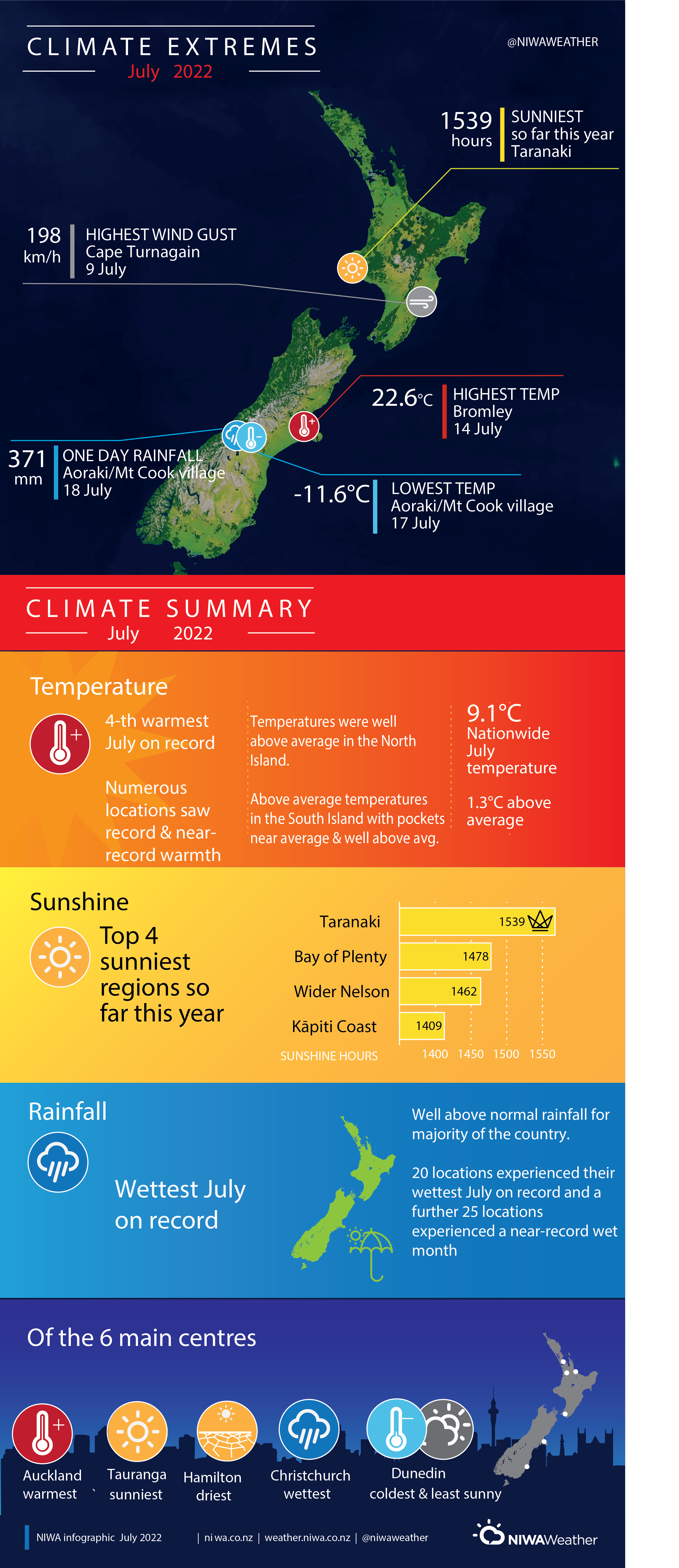
- The highest temperature was 22.6°C, observed at Bromley on 14 July.
- The lowest temperature was -11.6°C, observed at Aoraki/Mt Cook Airport on 17 July .
- The highest 1-day rainfall was 371 mm, recorded at Aoraki/Mt Cook village on 18 July.
- The highest wind gust was 198 km/h, observed at Cape Turnagain on 9 July.
- Of the six main centres in July 2022, Auckland was the warmest, Christchurch was the wettest, Hamilton was the driest, Tauranga was the sunniest and Dunedin was the coldest and least sunny.
- Of the available, regularly reporting sunshine observation sites, the sunniest four regions in 2021 so far are Taranaki (1539 hours), Bay of Plenty (1478 hours), Greater Nelson (1462 hours) and Kāpiti Coast (1409 hours).
Download
- Climate Summary July 2022 [PDF 5.74 MB]
- Climate Statistics Report July 2022 [PDF 154 KB]