A weekly update describing soil moisture patterns across the country to show where dry to extremely dry conditions are occurring or imminent. Regions experiencing significant soil moisture deficits are deemed “hotspots”. Persistent hotspot regions have the potential to develop into drought.
Recent rainfall and current soil moisture conditions
In the North Island, weekly rainfall totals of 20 to 40 mm were recorded for most of the Coromandel Peninsula, pockets of Northland, eastern Bay of Plenty, and about Tongariro and Taumarunui in the Manawatū-Whanganui. Elsewhere, the remainder of the North Island recorded less than 10 mm of rain over the past seven days, while many locations in the lower North Island received no rainfall at all. About Whangārei in Northland and the Manawatū-Whanganui, soil moisture increased slightly. A small to moderate decrease in soil moisture occurred across the remainder of North Island in the past week. The driest soils, when compared to normal for the time of year, are found about the Far North in Northland and along the coast of Taranaki from New Plymouth to Cape Egmont, with the wettest soils, when compared to normal for the time of year, are in Northland about Whangārei.
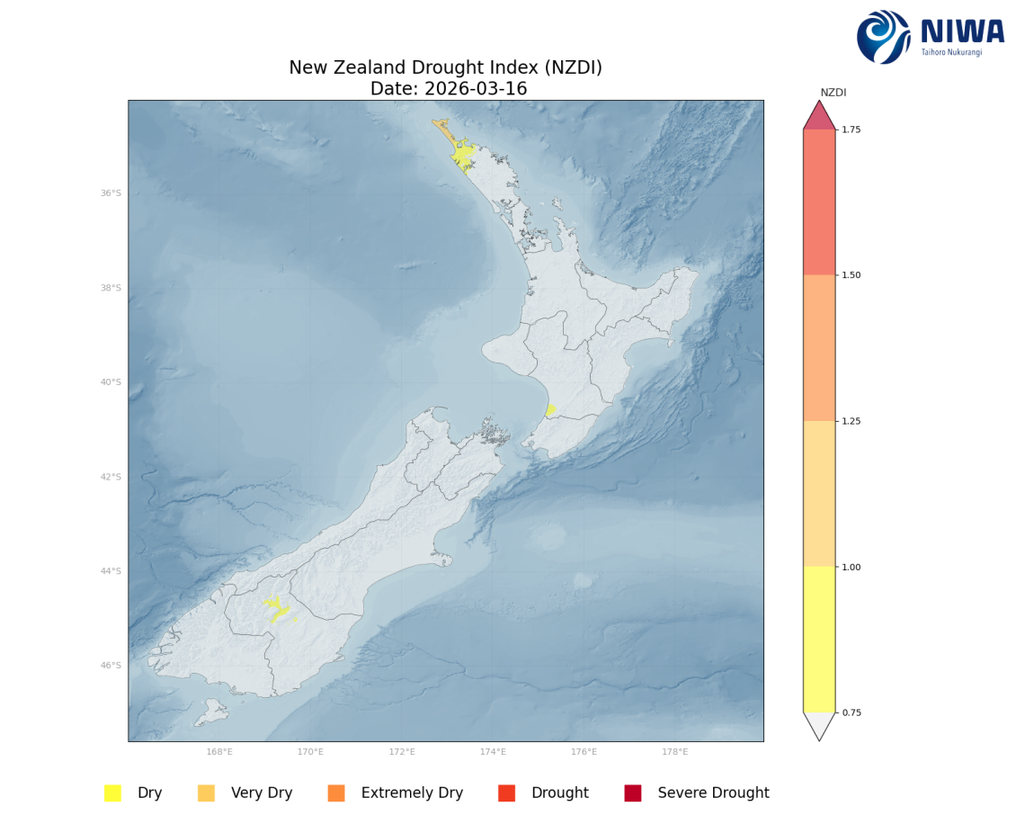
The hotspot in Northland about the Far North remains. Elsewhere, hotspots about the Manawatū-Whanganui coast near Foxton, in Auckland including Waiheke Island, in the Hauraki District southwest of Thames, and along the South Taranaki coast west of Hāwera have all grown or strengthened, while a new hotspot has formed along the Taranaki coast from Cape Egmont to New Plymouth. The hotspot in the Bay of Plenty just east of Whakatāne has dissipated. As of 16 March, the New Zealand Drought Index (NZDI) map shows abnormally dry conditions along the coast of the Horowhenua District and abnormally dry to very dry conditions in the Far North of Northland.
In the South Island, weekly rainfall totals of 30 to 50 mm were recorded in pockets of Southland and Otago, portions of Stewart Island, and coastal Westland. 50 to 100 mm of rain were recorded for the foothills and high elevations of the Southern Alps north of Mount Aoraki/Mount Cook and about the Tasman Mountains. Elsewhere, Fiordland and the remainder of Westland recorded 100 to 200 mm of rain, with a few locations seeing 200 mm or more over the past seven days. The remainder of the South Island generally recorded 5 to 25 mm of rain over the past week, with the lowest totals located Marlborough, Canterbury, and Otago about Wanaka. A small to moderate soil moisture increase occurred in southern Westland about Haast north to Ross, Westland north of Westport and across Stewart Island. Soil moisture remained the same for Fiordland, eastern Southland, and coastal Otago. For the remainder of the South Island, moderate to large soil moisture decreases occurred. The driest soils in the South Island, when compared to normal for the time of year, are in Westland about Reefton. The wettest soils, when compared to normal for the time of year, are in North Canterbury about Kaikōura and in Banks Peninsula.
The previous hotspot along the Nelson-Tasman border with Marlborough has weakened, while the hotspot in the Marlborough Sounds has strengthened. As of 16 March, the New Zealand Drought Index (NZDI) map shows a small area of abnormally dry conditions in Central Otago.
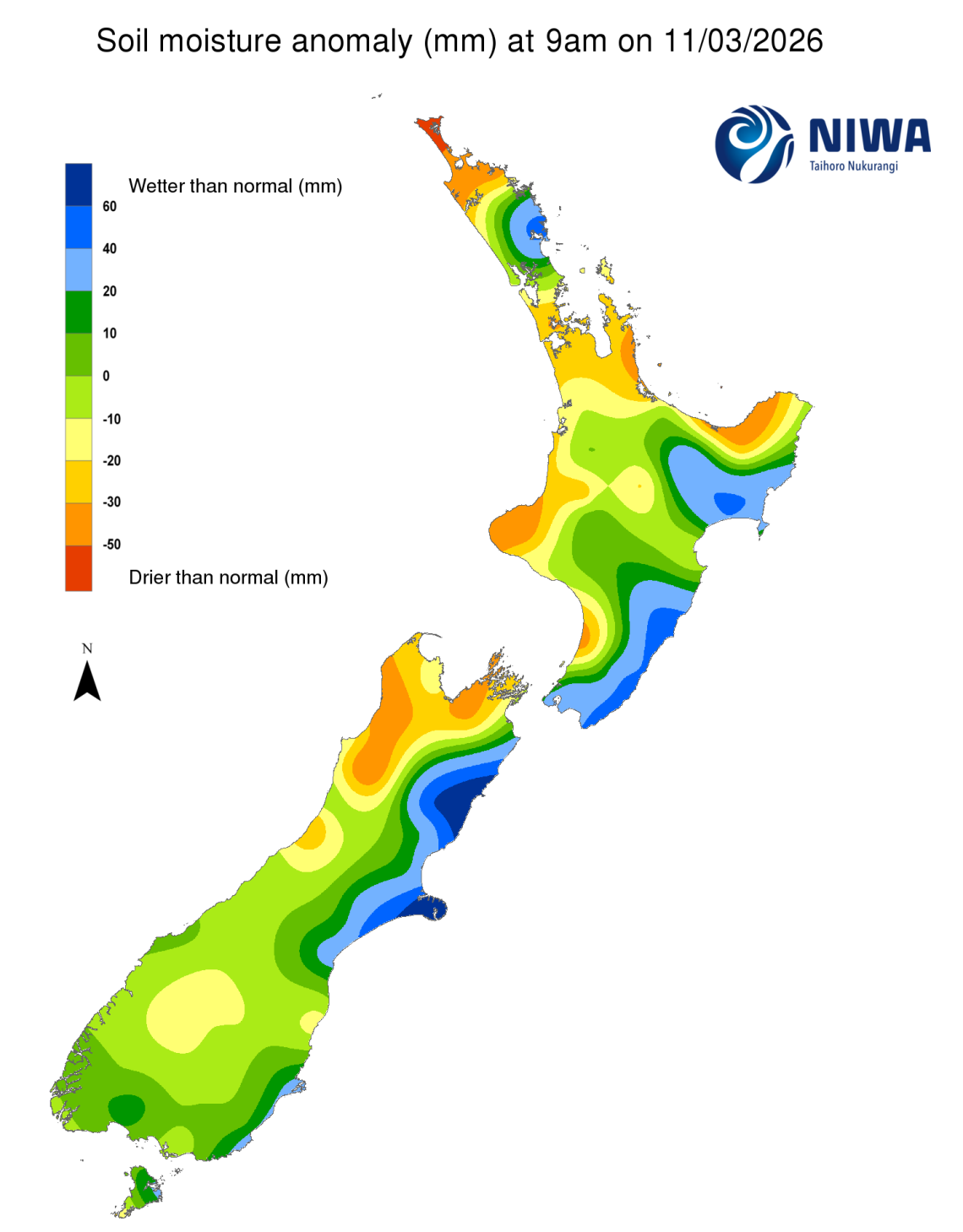
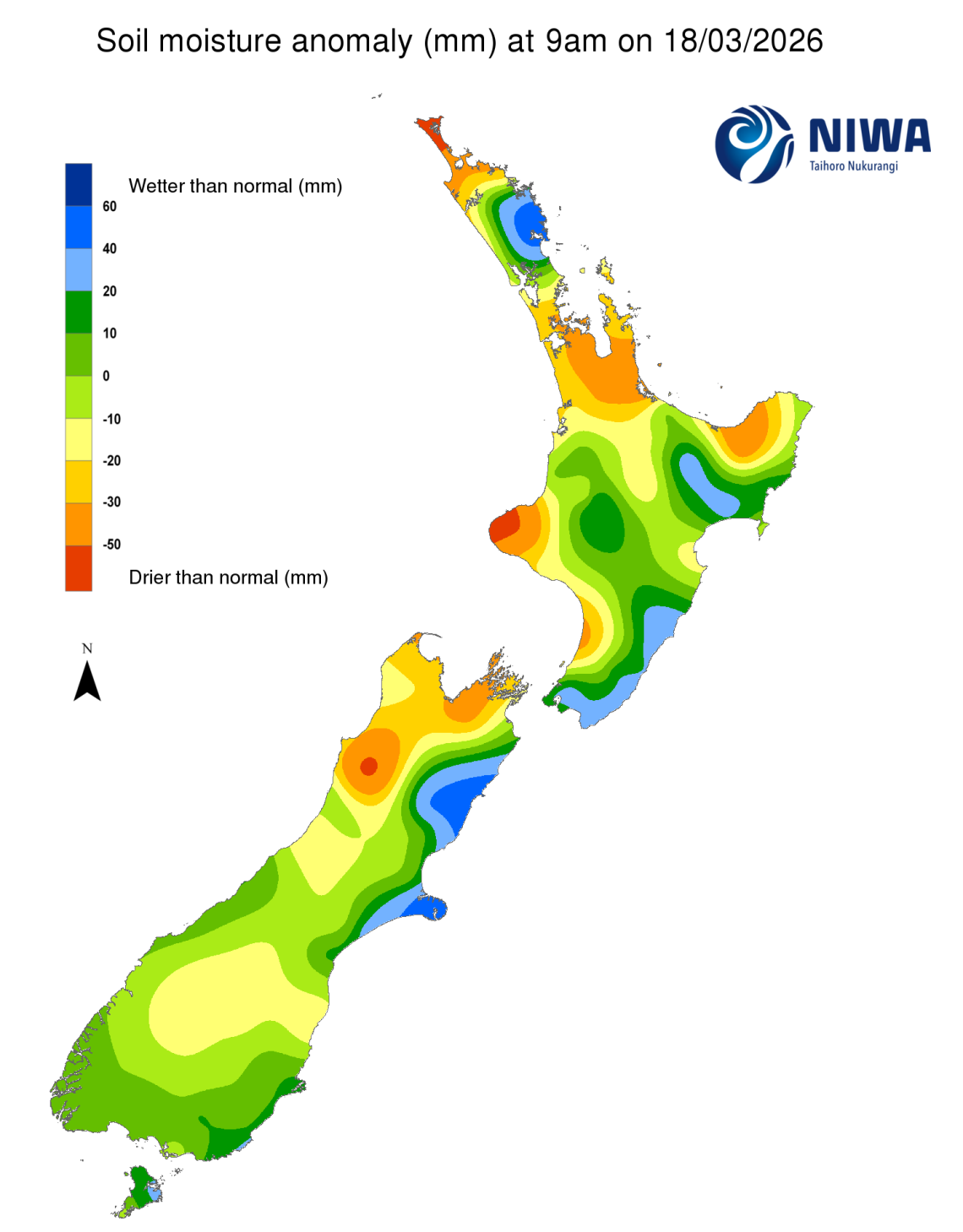
Pictured above: Soil Moisture Anomaly Maps, relative to this time of year. The maps show soil moisture anomalies over the past two weeks. As of 16 March, the New Zealand Drought Index (NZDI) map shows abnormally dry conditions along the coast of the Horowhenua District, abnormally dry to very dry conditions in the Far North of Northland, and abnormally dry conditions in a small area in Central Otago.
Please note: some hotspots in the text above may not correspond with the NZDI map. This difference exists because the NZDI uses additional dryness indices, including one which integrates the rainfall deficit over the past 60 days. Changes are therefore slower to appear in the NZDI compared to soil moisture anomaly maps that are instantaneously updated.
The week ahead
In the North Island, a tropical low located east of the North Island will slowly pull away, with high pressure building in for the next five to six days. Aside from a few showers about Gisborne, mostly settled weather is expected in this period up to Tuesday. Easterly flow will bring some moisture to the Northland, Auckland, and Coromandel region, especially Wednesday and beyond. Elsewhere, the North Island is mainly dry in the period. Large uncertainty exists regarding how a tropical low that forms in the southern Coral Sea will evolve, with a chance the low may move toward New Zealand as early as Wednesday and bring heavy rain to the North Island on Wednesday and Thursday (25-26 March). Weekly rainfall totals of 50 to 100 mm are expected for the Bay of Islands and the Far North in Northland, with 30 to 50 mm of rain expected for remainder Northland, north Auckland, and the Coromandel Peninsula, with isolated rain totals of 50 to 75 mm depending on the track and speed of the southward moving tropical low. However, rainfall totals may be much lower if the tropical low tracks farther west away from the North Island. The remainder of the North Island is expecting 10 to 30 mm of rain, with potential for 10 mm or less across Taranaki, Manawatū-Whanganui, southern Hawke’s Bay, and the Wellington region.
Due to the expected rainfall in the next week, soil moisture will likely increase in Northland, Auckland, and parts of the Waikato including the Coromandel Peninsula, unless the tropical low moves much farther west from the North Island than currently forecast, in which case soil moisture is likely to remain the same or decrease sightly. Elsewhere, soil moisture levels will likely see moderate to large decreases across the rest of the North Island. The hotspots in Auckland and the Far North may weaken based on current rainfall projections. Elsewhere, hotspots in the Hauraki District, Taranaki, and the Manawatū-Whanganui will remain the same or slightly strengthen and grow over the next week.
In the South Island, high pressure will build and remain in place over the next six days, with mostly settled weather. A few weak fronts will pass along the south of the South Island, with occasional showers or rain, especially about Fiordland. Otherwise, rain chances will be limited until Thursday (26 March) as a tropical low is expected to move toward New Zealand. Large uncertainty exists regarding how the tropical low pressure that forms in the southern Coral Sea will evolve. Rain or showers are likely on Thursday for the north and west of the South Island due to the tropical low and associated easterly wind flow. Weekly rainfall totals 20 mm or less are forecast for entire South Island, with potentially no rainfall for parts of Westland, Marlborough, Otago, and Canterbury.
Due to the expected rainfall in the next week, soil moisture levels are likely to see a moderate to large decrease for the entire South Island. The hotspots in Nelson-Tasman and Marlborough will likely strengthen and grow over the next seven day period. Additional hotspots may form in Westland about Reefton, Otago, and South Canterbury.
Long-term outlook (through mid-April)
- In the drier (25th percentile) scenario, drier than normal conditions are signalled for the entire country, with very dry conditions for Canterbury, Otago, Nelson-Tasman in the South Island, and very dry conditions for Auckland, the Waikato, the Bay of Plenty, the Manawatū-Whanganui, Taranaki, coastal Hawke’s Bay, and the Wairarapa in the North Island.
- The middle (50th percentile) scenario shows drier than normal conditions for the South Island except North Canterbury, and drier than normal conditions for all of the North Island except Northland, north Auckland, northern Hawke’s Bay, and much of Gisborne, and near normal conditions for the remainder of the country.
- In the wetter (75th percentile) scenario, dry conditions are signalled for Southland and much of Otago in the South Island, and for Taranaki and parts of the Ruapehu District in the North Island, while wet conditions are indicated for Northland, north Auckland, the east of the North Island, southern Marlborough, and Canterbury north of Christchurch in the South Island, and near normal conditions elsewhere.
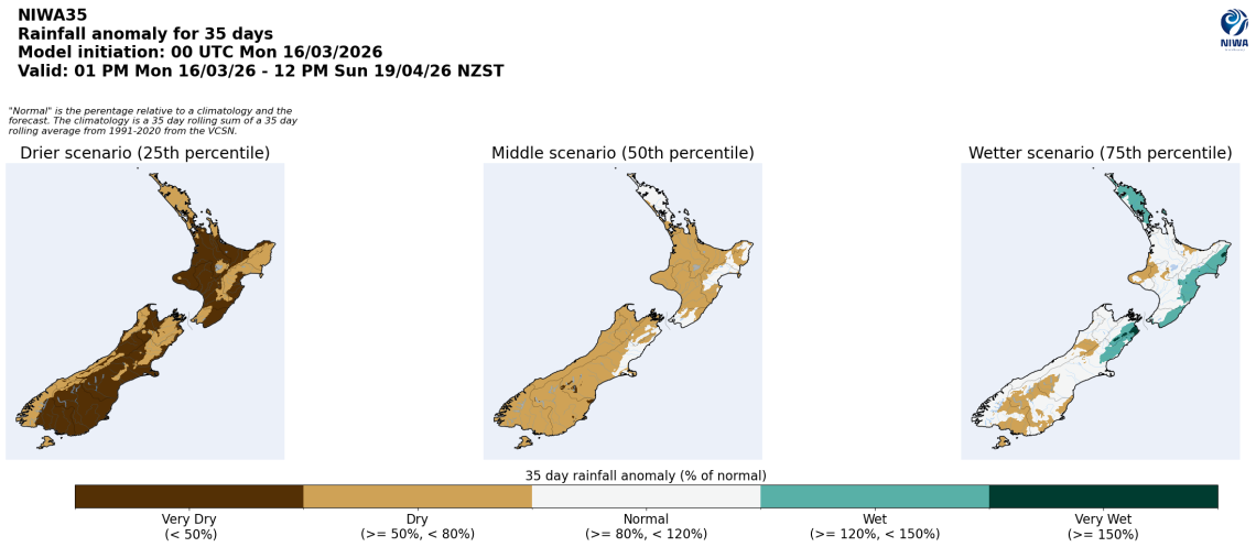
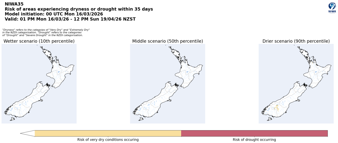
Pictured above: 35-day forecast rainfall anomaly scenarios (Top), and 35-day forecast dryness and drought scenarios (Bottom). These maps are updated daily at https://niwa.co.nz/climate/seasonal-climate-outlook
Background
Hotspot Watch: a weekly advisory service for New Zealand media. It provides soil moisture and precipitation measurements around the country to help assess whether extremely dry conditions are imminent.
Soil moisture deficit: the amount of water needed to bring the soil moisture content back to field capacity, which is the maximum amount of water the soil can hold.
Soil moisture anomaly: the difference between the historical normal soil moisture deficit (or surplus) for a given time of year and actual soil moisture deficits.
Definitions: “Extremely” and “severely” dry soils are based on a combination of the current soil moisture status and the difference from normal soil moisture (see soil moisture maps at https://www.niwa.co.nz/climate/nz-drought-monitor/droughtindicatormaps)
Hotspot: A hotspot is declared if soils are "severely drier than normal" which occurs when Soil Moisture Deficit (SMD) is less than -110 mm AND the Soil Moisture Anomaly is less than -20 mm.