A weekly update describing soil moisture patterns across the country to show where dry to extremely dry conditions are occurring or imminent. Regions experiencing significant soil moisture deficits are deemed “hotspots”. Persistent hotspot regions have the potential to develop into drought.
Recent rainfall and current soil moisture conditions:
In the North Island, weekly rainfall totals of 100 to 200 mm were recorded for eastern Northland, eastern Auckland region, the Coromandel Peninsula and the north of Waikato, western Bay of Plenty, and about Taranaki Maunga, with a few spots recording more than 200 mm of rain in the Coromandel. The remainder of Northland except about Cape Reinga, remainder Auckland, about Tongariro, in the east of Bay of Plenty about Cape Runaway and north Gisborne about Hicks Bay 50 to 100 mm of rain were recorded. Elsewhere, 25 mm or less were recorded for most of the Wellington region, South Taranaki, the southern portion of Manawatū-Whanganui, Hawke’s Bay, and south of Gisborne. The remainder of the North Island received 25 to 50 mm of rain over the past seven days. The west and south of Northland, Auckland, the Waikato, Taranaki, northern Manawatū-Whanganui, Bay of Plenty, and northern Gisborne experienced a moderate to large increase in soil moisture over the last week. Soil moisture remained the same or decreased slightly across the remainder of the North Island. The driest soils, when compared to normal for the time of year, are found about Taranaki Maunga, the Horowhenua and Manawatu districts, and about Napier in Hawke’s Bay. The wettest soils, when compared to normal for the time of year, are in the western Bay of Plenty, west of Northland, and west and north of the Auckland region.
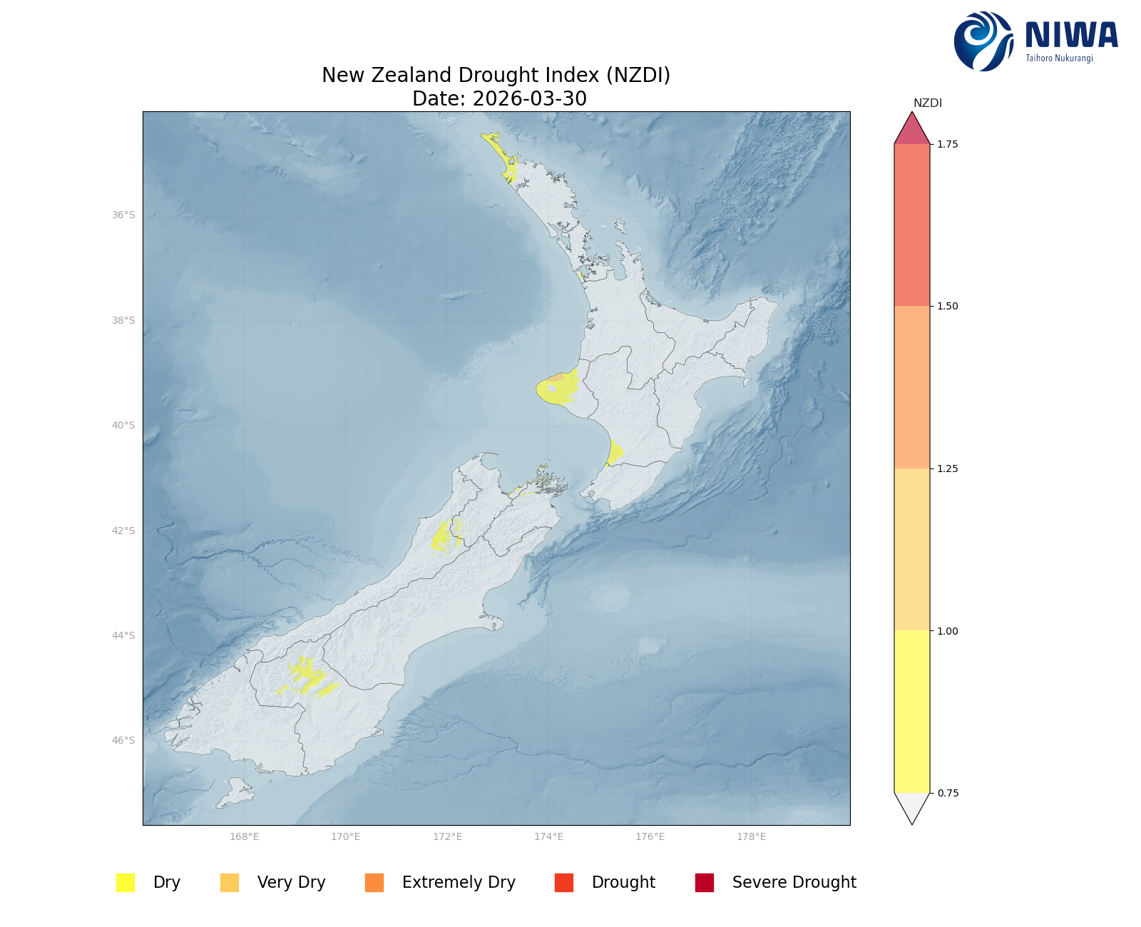
The previous hotspots in Waikato and Taranaki have dissipated in the past week. Elsewhere, hotspots about the Manawatū-Whanganui coast near Foxton and in Hawke’s Bay about Napier and Hastings remain the same or have strengthened. As of 30 March, the New Zealand Drought Index (NZDI) map shows abnormally dry conditions along the coast of the Horowhenua District, about the Taranaki coast, and western Northland.
In the South Island, weekly rainfall totals of 100 to 200 mm of rain were recorded about parts of Fiordland, Westland south of Hokitika, the ranges and foothills between Reefton and Westport, and the ranges of western and southern Tasman region, with 200 to 300 mm in portions of the Southern Alps and the ranges in the Tasman region. 50 to 100 mm of rain were recorded in remainder of Tasman, Nelson, western Marlborough, remaining Fiordland, small portions of inland Southland, and the Kakanui Mountains in Otago. The remainder of the South Island from eastern Marlborough to northern Otago generally recorded less than 30 mm of rain over the past week. Soil moisture generally remained the same for the Canterbury low country and for Canterbury about Kaikōura and the nearby ranges. Elsewhere, a moderate to large soil moisture increase occurred for nearly the entire South Island. The driest soils in the South Island, when compared to normal for the time of year, are in Westland about Reefton. The wettest soils, when compared to normal for the time of year, are in Tasman about Tākaka.
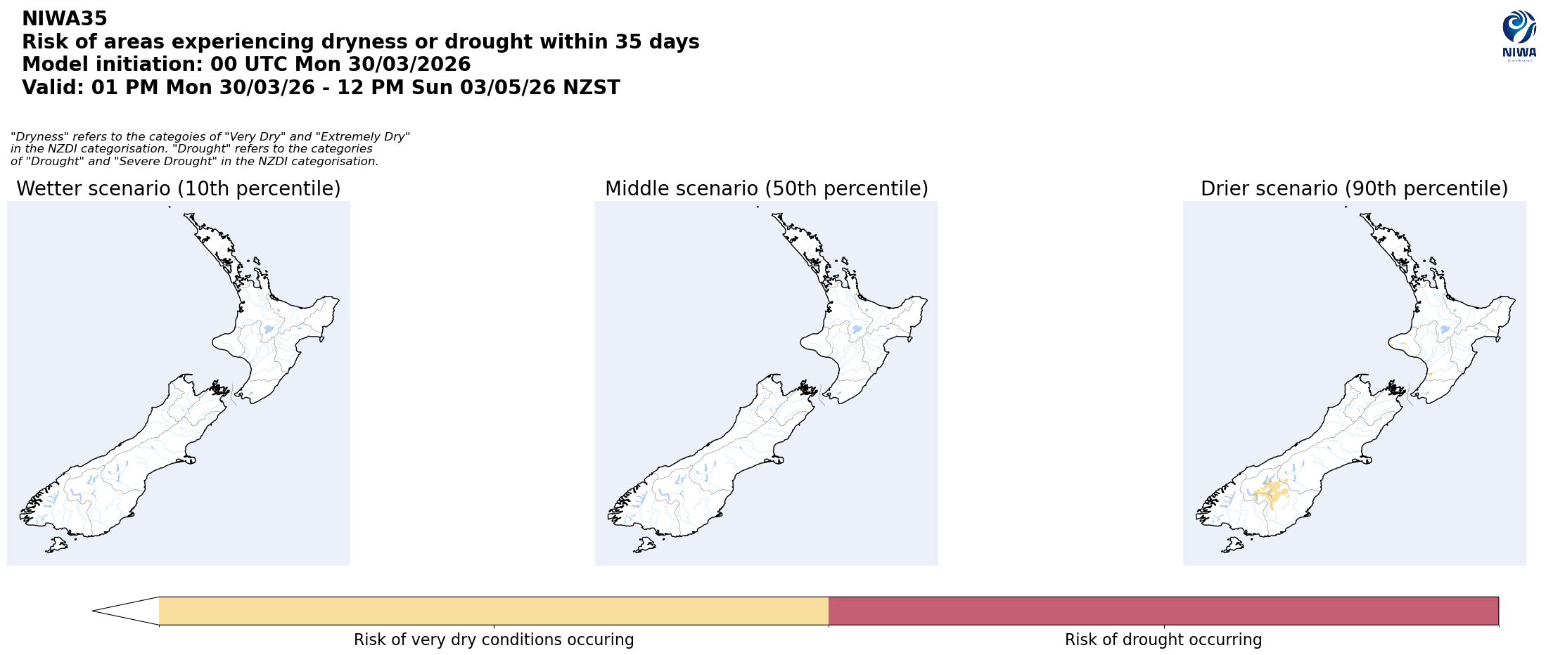
All previous hotspots in the South Island have dissipated in the past week. As of 30 March, the New Zealand Drought Index (NZDI) map shows abnormally dry conditions in Central Otago and in a small area of Westland about Reefton.
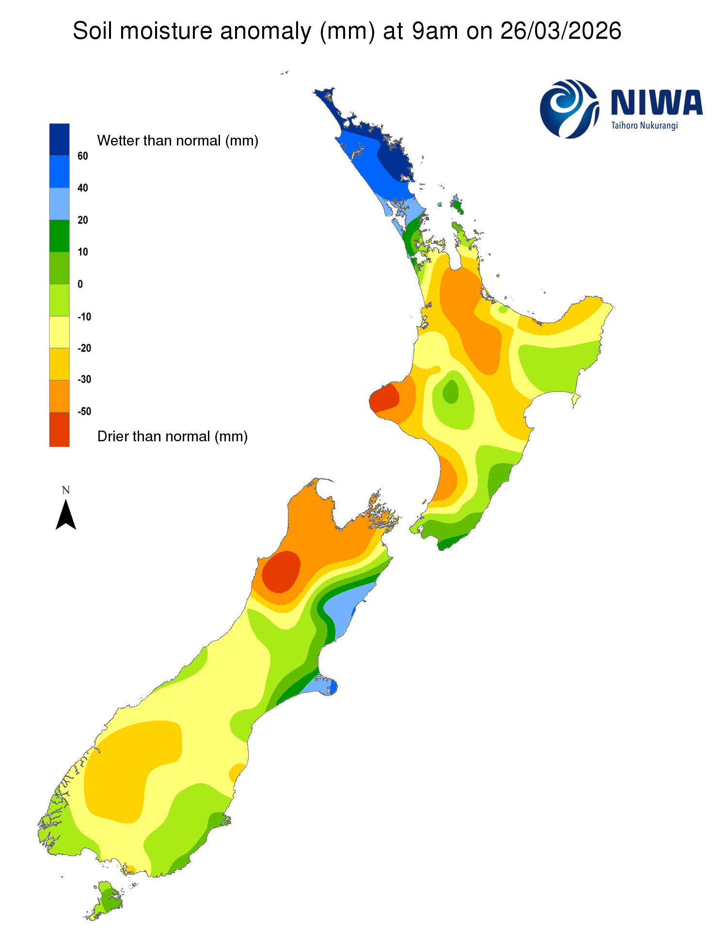
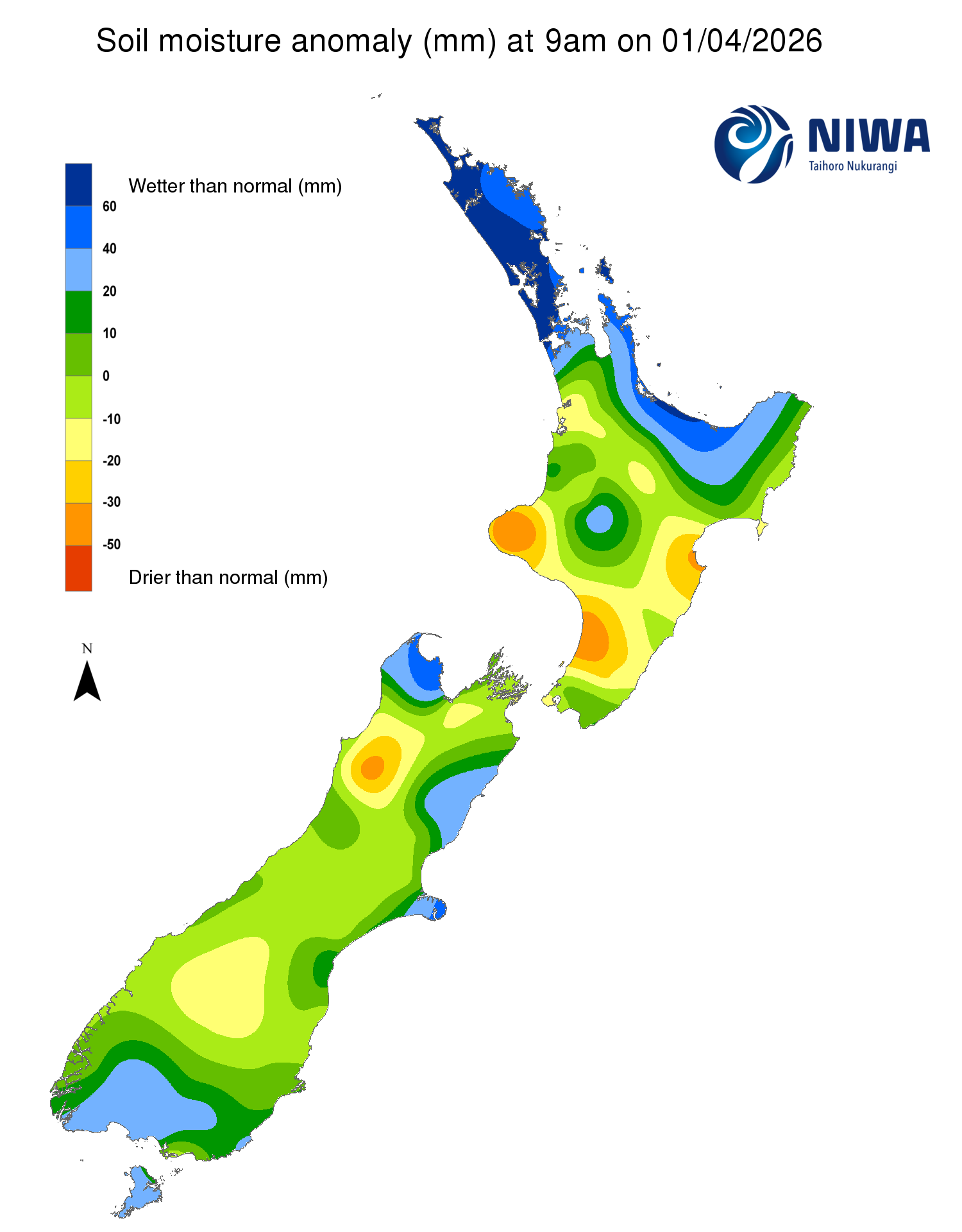
Pictured above: Soil Moisture Anomaly Maps, relative to this time of year. The maps show soil moisture anomalies over the past two weeks.
New Zealand Drought Index (NZDI)
As of 30 March, the New Zealand Drought Index (NZDI) map shows abnormally dry conditions along the coast of the Horowhenua District, about the Taranaki coast, western Northland, Central Otago, and in a small area of Westland about Reefton.
Please note: some hotspots in the text above may not correspond with the NZDI map. This difference exists because the NZDI uses additional dryness indices, including one which integrates the rainfall deficit over the past 60 days. Changes are therefore slower to appear in the NZDI compared to soil moisture anomaly maps that are instantaneously updated.
The week ahead:
In the North Island, a ridge sits over New Zealand on Friday (3 April), bringing settled weather. Over the weekend, the ridge moves east, away from the country, with increasing easterly flow for the top of the North Island. A few showers are possible across the North Island through the weekend, with more widespread rain expected Monday with a developing area of low pressure over the Tasman Sea. The area of low pressure and an associated front will linger west of the country, then move slowly eastward from sometime on Monday into Wednesday or Thursday, with low confidence on how the weather forecast will evolve for the remainder of the period. The slow moving low pressure will lead to periods of rain across the North Island, with potential heavy rain across the north of the North Island at some point between Tuesday and Thursday (7-9 April). Weekly rainfall totals of 50 to 100 mm are possible for Northland, the Coromandel Peninsula, and the western Bay of Plenty, with the potential for greater than 100 mm depending on the speed of the slow moving low pressure system next week. Elsewhere, expect 30 to 50 mm of rain for the remainder of the Bay of Plenty, Auckland, remaining Waikato, Gisborne, and the foothills and ranges of Hawke’s Bay, with isolated higher totals possible. The remainder of the North Island will likely receive 10 to 30 mm of rain over the next seven days.
Due to the expected rainfall in the next week, the western and lower North Island will see a small to moderate decrease in soil moisture, with the upper North Island potentially seeing a large increase in soil moisture if heavy rain eventuates. The hotspots in the Manawatū-Whanganui and Hawke’s Bay will likely remain and possibly grow over the next week, while additional hotspots may form about Taranaki Maunga and the Wairarapa.
In the South Island, a front will approach the West Coast, with moist northerly flow ahead of the system, leading to rain in the west and south on Friday and Saturday. The front weakens by Sunday (5 April), with an area of low pressure developing over the Tasman Sea, somewhere near New Zealand. Forecast confidence is low for the remainder of the period, with the low pressure and front likely to move across the South Island from Tuesday through Thursday (7-9 April), bringing periods of showers and rain in moist northeasterly wind flow. Weekly rainfall totals of 50 to 100 mm are expected about Westland, with isolated amounts of 150 mm or greater possible. For western Southland and western Tasman, weekly rainfall totals of 30 to 50 mm are expected, however there is lower confidence in the Tasman region, with the potential to receive only 10 to 30 mm over the next week. The remainder of the South Island is likely to record 10 to 30 mm of rain over the next seven days, with isolated totals of 30 to 50 mm depending on how fast the slow-moving low pressure and front moves across the country.
Due to the expected rainfall in the next week, soil moisture levels are likely to remain the same or increase slightly across western Tasman, Westland, and Fiordland. For the remainder of the South Island, soil moisture will likely see a small to moderate decrease. Hotspots may return to Otago and Westland about Reefton.
Long-term outlook (through early-May):
- In the drier (25th percentile) scenario, drier than normal conditions are signalled for the entire country, except for the east of the North Island, with very dry conditions for Southland and Otago in the South Island, very dry conditions for the Ruapehu District in the North Island, and near normal conditions elsewhere.
- The middle (50th percentile) scenario shows drier than normal conditions for the west and south of South Island and a small portion of the Manawatu-Whanganui in the North Island, wet conditions for Northland, Gisborne, and Canterbury about Kaikōura, wet to very wet conditions for Hawke’s Bay, and near normal conditions for the remainder of the country.
- In the wetter (75th percentile) scenario, dry conditions are signalled for portions of Southland, inland Otago, Fiordland, and Westland, wet to very wet conditions are expected for the north and east of the South Island and the south, east, and north of the North Island, and near normal conditions elsewhere.
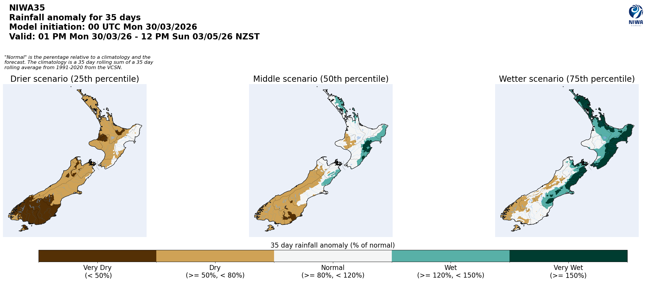
Pictured above: 35-day forecast rainfall anomaly scenarios (Top), and 35-day forecast dryness and drought scenarios (Bottom). These maps are updated daily at https://niwa.co.nz/climate/seasonal-climate-outlook
Background:
Hotspot Watch: a weekly advisory service for New Zealand media. It provides soil moisture and precipitation measurements around the country to help assess whether extremely dry conditions are imminent.
Soil moisture deficit: the amount of water needed to bring the soil moisture content back to field capacity, which is the maximum amount of water the soil can hold.
Soil moisture anomaly: the difference between the historical normal soil moisture deficit (or surplus) for a given time of year and actual soil moisture deficits.
Definitions: “Extremely” and “severely” dry soils are based on a combination of the current soil moisture status and the difference from normal soil moisture (see soil moisture maps at https://www.niwa.co.nz/climate/nz-drought-monitor/droughtindicatormaps)
Hotspot: A hotspot is declared if soils are "severely drier than normal" which occurs when Soil Moisture Deficit (SMD) is less than -110 mm AND the Soil Moisture Anomaly is less than -20 mm.