This project ran from 2019 - please see PARTneR-2+ for the next stage of the work
On this page:

The Pacific Community (SPC) | Cook Islands | Republic of Marshall Islands | Samoa | Tonga | Tuvalu | Vanuatu | New Zealand
Hazard risk modelling tools can help decision makers to better prepare for and respond to disasters and to make sound economic and land-use planning decisions. PARTneR–2 is addressing a critical gap across the Pacific region in the availability and use of low-cost and easily-applied tools to support risk-informed decisions.
The three-year PARTneR–2 project is helping countries in the Pacific become more resilient to the impacts of climate-related hazards. It builds on the pilot PARTneR project, which ran from 2016-2019.
Resilience to climate-related hazards
PARTneR-2 is working across six Pacific Island Countries (PICs) to build capability to make risk-informed and effective development decisions. It is advancing a shared understanding of the different needs for climate risk information and co-developing national risk models and assessment tools with PICs.
The project involves collaborating with central government agencies in each country to identify their risk-information needs and priorities, and developing the required skills and capacity within technical line ministries to deliver actionable information to meet these needs.
Project delivery
The PARTneR–2 project is funded by the New Zealand Ministry of Foreign Affairs and Trade (MFAT). It is jointly delivered by The Pacific Community (SPC) and NIWA, in collaboration with the partner countries.
PARTneR–2 is working closely with other partners and programs in the Pacific region to ensure efforts to inform risk-based decision-making are well aligned.
It is supporting PICs to deliver on the Framework for Resilient Development in the Pacific (FRDP), the Sendai Framework for Disaster Risk Reduction, the Paris Agreement to the United Nations Framework Convention on Climate Change, and the United Nations’ Sustainable Development Goals.
The PARTneR-2 approach involves:
- Working through existing cross-government coordination mechanisms to integrate risk-assessment information and tools into in-country processes.
- Enhancing collaboration and coordination throughout the decision-making process.
- Formalising governance arrangements for data and analysis.
- Developing fit-for-purpose information products.
- Building capacity and raising awareness across all levels of decision makers.
- Training and use of risk assessment software (utilising RiskScape, see box below).
- Further developing technical capacity within SPC to underpin and support PICs.

Outcomes and outputs
Outcome areas:
 |
Risk information is being produced to support effective decision-making and reporting in PICs through collaboration with partner programmes. |
|

|
PICs have the skills and knowledge to use climate risk information in their decision-making and reporting processes. |

|
Regional and peer-to-peer support is available and coordinated across PICs. |
Key outputs:
 | National risk models for six PICs and regional capability is developed. |

|
Climate-related risk outputs are defined and produced for key national and sectoral decision-making and reporting mechanisms. |

|
Risk data collection and management is operational in six PICs in collaboration with aligned partner programmes. |

|
Technical and end-user Communities of Practice (CoP) are operational within and between the six PICs and key regional support agencies. |
Project use cases
Delivery of the PARTneR-2 project involves three key use cases encompassing the development of climate and extreme weather hazard and risk information to inform sectoral decision processes at regional and national scales.
These use cases were scoped and co-developed with PARTneR-2 project stakeholders in each participating country during the initial inception and planning phases of the project in 2022. These three national use cases have wide-ranging applications.
Use case 1: National coastal inundation risk profiles
Use case 1 developed sea-level inundation risk profiles for population, buildings, croplands and critical infrastructure, under present and future climate scenarios (based on IPCC projections) at a national scale. The risk information is reported and visualised at asset, island and provincial/ district levels. Tailored outputs provide evidence supporting each country’s unique needs. For example, for climate adaptation investment proposals, identifying critical at-risk areas and timing of rising sea levels to inform infrastructure planning.
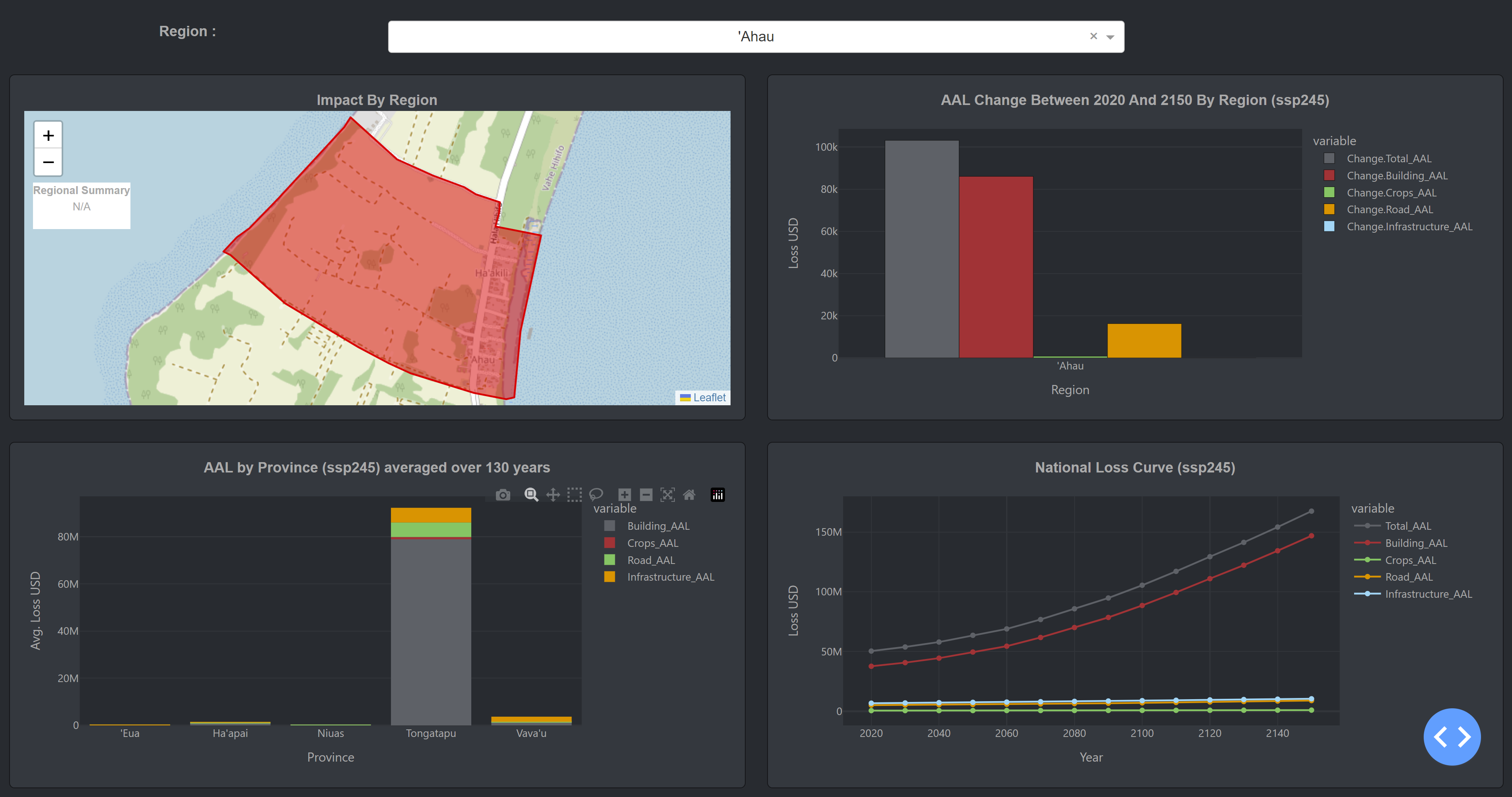
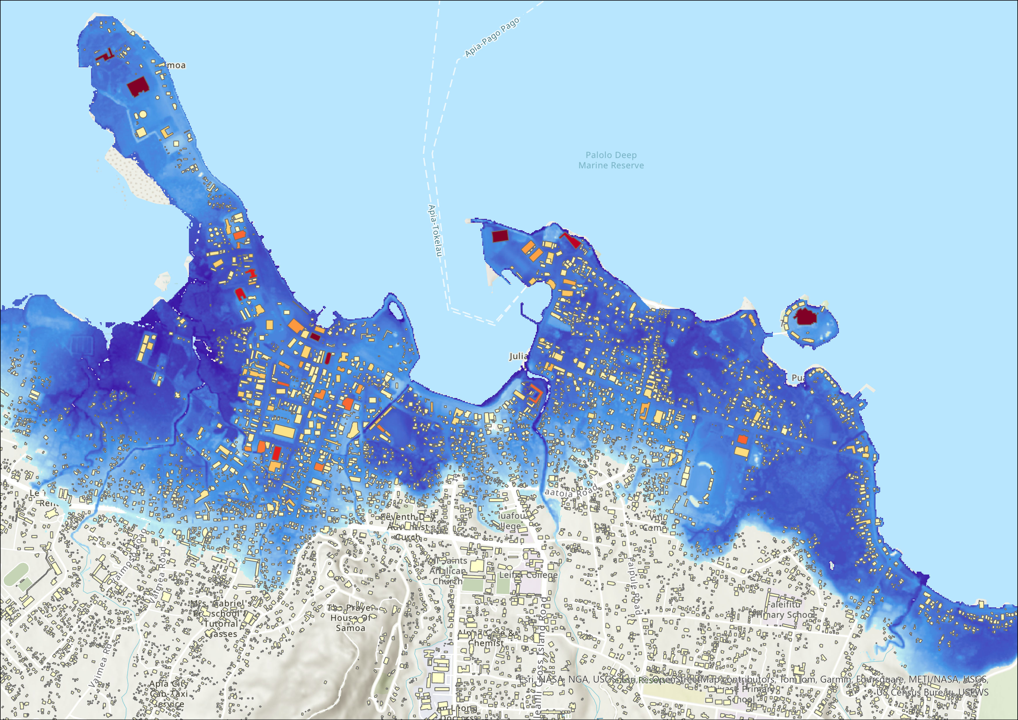
Table shows the results from the map above aggregated by building use type:
| Use type | Exposed buildings | Total buildings | Total loss (USD) |
|---|---|---|---|
| Commercial | 1404 | 4433 | 32,974,801 |
| Educational | 18 | 119 | 5,106,160 |
| Industrial | 69 | 268 | 5,082,363 |
| Infrastructure | 66 | 251 | 5,187,877 |
| Institutional | 16 | 42 | 7,540,349 |
| Outhouse building | 921 | 4717 | 6,462,135 |
| Public | 402 | 1660 | 14,992,597 |
| Residential | 11478 | 45964 | 127,692,073 |
| Other | 4406 | 30961 | 35,042,146 |
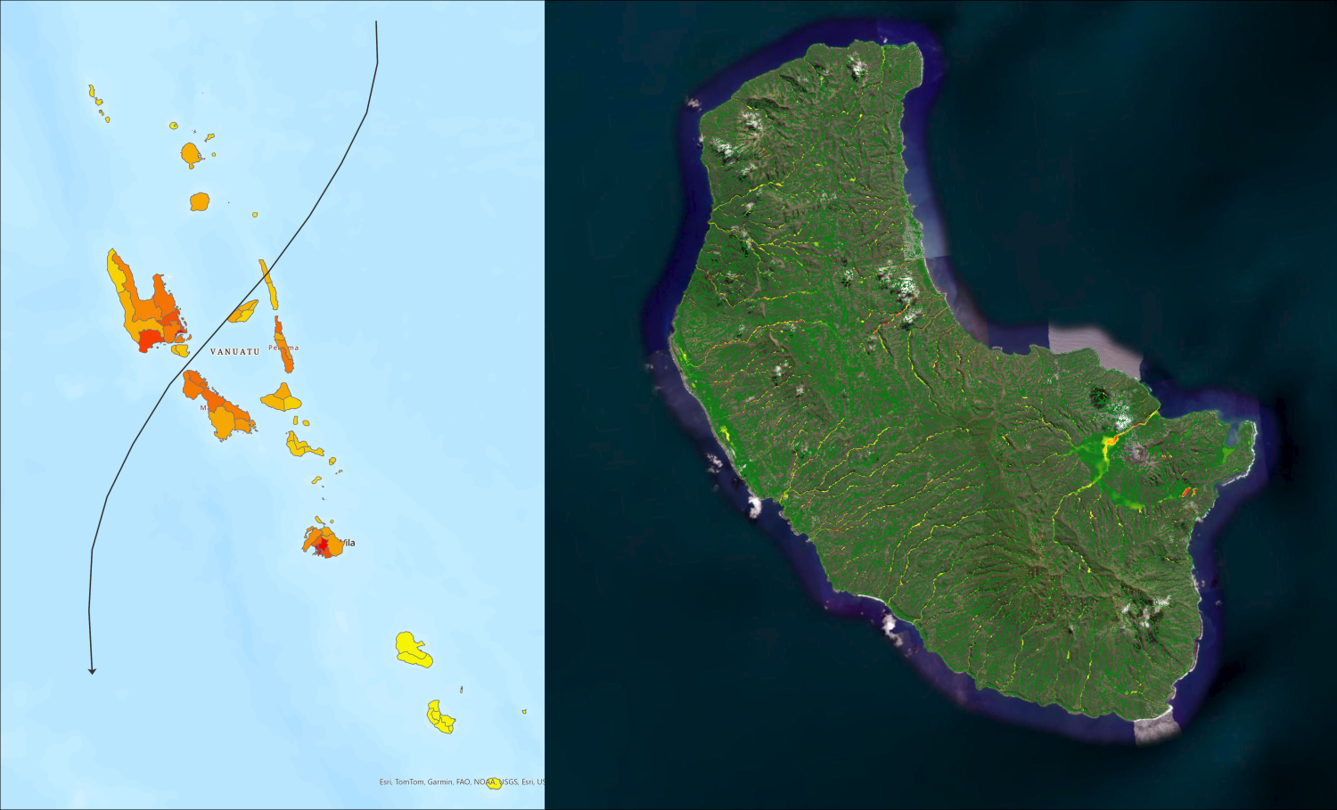
Use case 2: Tropical cyclone risk model
Use case 2 has two parts, relating to before and after a tropical cyclone event occurs.
Part 1 is a Rapid Exposure Forecast for up to three days before a tropical cyclone. This focuses on the population, buildings, critical infrastructure and utilities exposed to forecasted wind speeds and storm surge at a national scale for Cook Islands, Samoa, Tonga and Vanuatu.
Part 2 provides event-based impact estimations after a tropical cyclone occurs, such as damage and losses for population, buildings, critical infrastructure, utilities and croplands from wind, rainfall and river flooding, and storm surge hazards. This information can be used to support national-scale Initial Damage Assessments, and regional to national scale Post-Disaster Needs Assessments.
Risk information for both parts are reported at feature, island, provincial/district and national scales and tailored outputs provide information to support each country’s unique needs i.e. for:
- identification of critical at-risk areas
- national cluster support for preparedness and response, and
- event loss estimations to make national decisions on declaring states of emergency, insurance claims, recovery financing, etc.
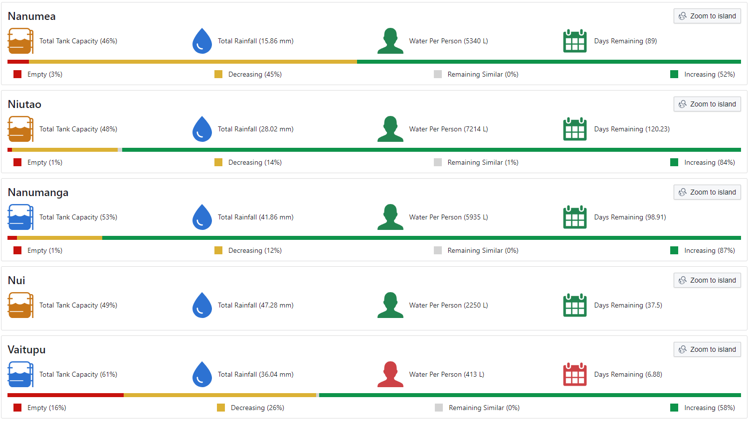
Use case 3: Water resource forecasting tool
Use case 3 developed a water resource forecasting tool to aid the Marshall Islands and Tuvalu governments to plan ahead for water shortages and drought. This tool estimates the amount of water available at the end of each scenario (between 1 day and 6 months) based on the rainfall forecast and localised water consumption rates.
The tool allows users to choose an automated rainfall forecast or input their own rainfall forecast (or no rainfall), what water resources are available, the number of people using the water resource, and the average water consumption rates per person. Forecasted water availability is presented at a household, island and national scale through an interactive dashboard. Outputs are available as a printable PDF report, Excel or Shapefiles to download. The tool helps national and local governments and communities to prepare for and take actions to prevent water shortages and drought.

Contacts