| Temperature | January temperatures were well above average (>1.20°C above average) for small portions of the Coromandel, western Northland, coastal Gisborne, the Māhia Peninsula, and western Tasman. Above average temperatures (0.51-1.20°C above average) were recorded for the remainder of Northland, most of Auckland, the Bay of Plenty, the Waikato, about the Central Plateau, Hawke’s Bay, and remainder Gisborne, as well as coastal areas of Fiordland, Westland, and far western Tasman. Below average temperatures (0.51-1.20°C below average) occurred in all of interior Otago, northern Southland, northern Canterbury and a small portion of mid-Canterbury, with near average temperatures (±0.50°C) elsewhere. |
| Rainfall | Rainfall was well above normal (>149% of normal) or above normal (120-149% of normal) in Canterbury, Marlborough, Nelson, Tasman, majority of the Waikato, Bay of Plenty, Gisborne, Taranaki, majority of Manawatū-Whanganui, Wellington, Auckland, and Northland, with portions of the Coromandel and Bay of Plenty exceeding 400% of normal. Rainfall was below normal (50-79% of normal) or well below normal (<50% of normal) in the West Coast, Southland, and much of Central Otago. Elsewhere, near normal rainfall (80-119% of normal) fell in January. |
| Soil Moisture | At the end of January, soil moisture levels were higher than normal in eastern Northland, Auckland, Bay of Plenty, the Waikato, Gisborne, Hawke’s Bay, Taranaki, northern and eastern Manawatū-Whanganui, majority of Wellington, Nelson, Tasman, northern Westland, Marlborough, Canterbury, and coastal areas of Otago. Soil moisture levels were lower than normal in lower Westland, Fiordland, most of Southland, the far west of Otago and western Northland. Near normal soil moisture levels were observed in the remainder of the country. |
Overview
January 2026 continued the summer theme of lower than normal mean sea level pressure (MSLP) over Aotearoa New Zealand, primarily driven by two long-lived areas of low pressure, one tropical and one subtropical, during the second half of the month. La Niña conditions continued through the month of January, despite La Niña weakening during the month. Sea surface temperatures (SSTs) surrounding New Zealand were mostly above average, however the SST anomalies eased throughout the month due to the aforementioned pair of low pressure systems and increased windiness across New Zealand’s waters. At the end of January, Marine Heatwave (MHW) conditions were no longer present across any of New Zealand’s coastal areas.
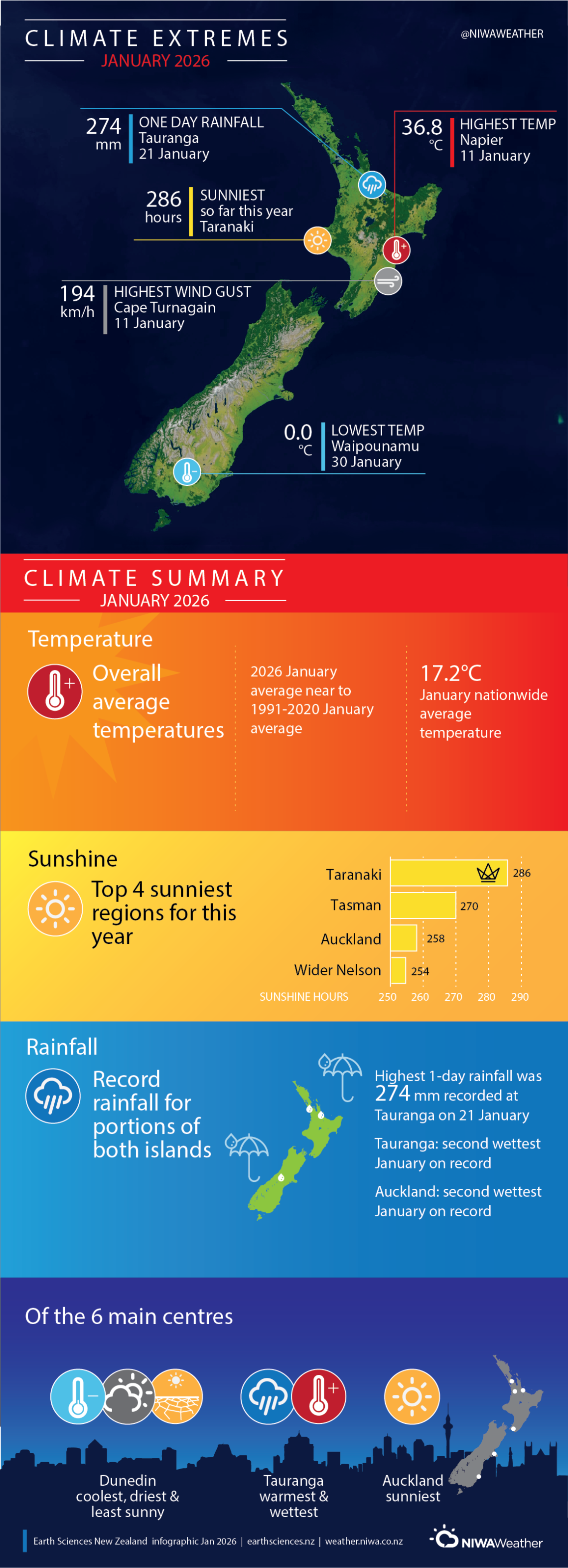
The nationwide average temperature in January 2026 was 17.2°C. This is right at the 1991-2020 January average. While there were several periods dominated by high pressure, overall the month was unsettled much like December, with a distinct tropical connection around the middle to end of the month, leading to warm nights and record setting rainfalls. Temperatures were well above average (>1.20°C above average) for small portions of the Coromandel, western Northland, coastal Gisborne, the Māhia Peninsula, and western Tasman. Above average temperatures (0.51-1.20°C above average) were recorded for the remainder of Northland, most of Auckland, the Bay of Plenty, the Waikato, about the Central Plateau, Hawke’s Bay, and the remainder of Gisborne, as well as coastal areas of Fiordland, Westland, and far western Tasman. Below average temperatures (0.51-1.20°C below average) occurred in all of interior Otago, northern Southland, northern Canterbury and a small portion of mid-Canterbury, with near average temperatures (±0.50°C) elsewhere.
Tropical air poured across New Zealand from 18-22 January, which led to record setting rainfall and flooding for large portions of the North Island and upper South Island. Rainfall was well above normal (>149% of normal) or above normal (120-149% of normal) in Canterbury, Marlborough, Nelson, Tasman, majority of the Waikato, Bay of Plenty, Gisborne, Taranaki, majority of Manawatū-Whanganui, Wellington, Auckland, and Northland, with portions of the Coromandel, Bay of Plenty, and North Canterbury exceeding 300-400% of normal. Rainfall was below normal (50-79% of normal) or well below normal (<50% of normal) for the West Coast, Southland, and much of Central Otago. Elsewhere, near normal rainfall (80-119% of normal) fell in January.
Further highlights:
- The highest temperature was 36.8°C, observed at Napier on 11 January.
- The lowest temperature was 0.0°C, observed at Waipounamu on 30 January.
- The highest 1-day rainfall was 274 mm, recorded at Tauranga on 21 January.
- The highest wind gust was 194 km/h, observed at Cape Turnagain on 11 January.
- Of the six main centres, Tauranga was the warmest and wettest, Dunedin was the coolest, driest, and least sunny, and Auckland was the sunniest.
- The sunniest four regions in 2026 so far are Taranaki (286 hours), Tasman (270 hours), Auckland (258 hours), and wider Nelson (254 hours).
[1] Defined as five or more consecutive days with SSTs above the 90th percentile for the time of year.
