Thursday, 1 May 2003
Sunny with well below average rainfall in Waikato, Wanganui, Manawatu, Wellington, Wairarapa, Westland, Fiordland, Marlborough, Alpine areas, Otago and Southland Significant soil moisture deficits persist in Wanganui, Manawatu, Horowhenua, South Canterbury and Central Otago Above average rainfall in Bay of Islands, Coromandel, and north and central Canterbury Warmer in parts of Auckland, Bay of Plenty, Waikato, and Buller, but colder in Wellington, Wairarapa, Marlborough, Canterbury, Otago and Southland
April was a month of regional contrasts. Many western regions experienced an extremely dry and sunny April. However, it was much colder than usual in the south and east of the South Island.
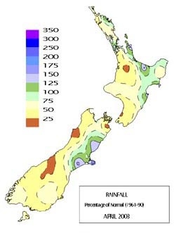
Extremely low rainfall, about 33 percent (a third) of average, occurred in most of the South Island west coast and some alpine areas. It was also dry, with rainfall less than 50 percent (half) of average in most other western regions from Waikato to Fiordland, as well as in central Wairarapa, Wellington, central Marlborough, Otago and Southland. Totals were also below average in south Auckland, Taranaki, and King Country. Significant soil moisture deficits continued throughout the east of the South Island, from south Canterbury to Central Otago, as well as in the southwest North Island from Wanganui to the Kapiti coast. In contrast, rainfall was above average in the Bay of Islands, parts of Auckland, Coromandel, areas of Bay of Plenty, southern Marlborough, Banks Peninsula and coastal Canterbury.
Significant rainfall occurred throughout Nelson, in Bay of Plenty, the Gisborne high country, and Canterbury over the 5th and 6th, with widespread surface flooding in Nelson. High rainfall and surface flooding also occurred in Northland and Coromandel townships on the 19th and 20th.
High rainfall, totalling about 100 mm, was measured in parts of Fiordland on the 30th.
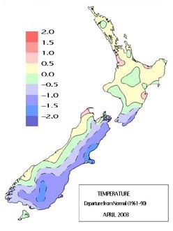
Mean temperatures were average or above average across much of the North Island and the west of the South Island. However it was colder than average in the east from southern Wairarapa to Southland, some areas being more than 1.5°C below normal. The national average temperature of 12.9°C was 0.4°C below normal.
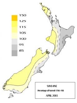
Sunshine hours were above average in the west from Northland to Fiordland. Less sunshine than usual occurred in many eastern regions from Hawke’s Bay to Southland.
April’s climate pattern was dominated by more frequent anticyclones (‘highs’) to the south and southwest of New Zealand, with more frequent depressions (‘lows’) to the north of the North Island. These systems produced more frequent easterlies and south-easterlies than usual over New Zealand.
Well below average rainfall in many western regions Above average rainfall in some northern and eastern areas
Rainfall totals were about 33 percent (a third) of average along most of the South Island west coast, and less than 50 percent (half) of average in most other western regions from Waikato to Fiordland, as well as central Wairarapa, Wellington, Otago and Southland. It was very dry in central Marlborough with totals about 25 percent (quarter) or less of average. Rainfall was less than 75 percent (three quarters) of average in south Auckland, Taranaki, and King Country.
Very low April rainfall was recorded at:
| Location | April rainfall (mm) | Percentage of normal | Year records began | Comments |
|---|---|---|---|---|
| Pukekohe | 27 | 24 | 1970 | 2nd lowest |
| Levin | 21 | 28 | 1896 | 3rd equal lowest |
| Paraparaumu Airport | 17 | 21 | 1945 | 3rd lowest |
| Westport Airport | 48 | 25 | 1944 | 2nd lowest |
| Hokitika Airport | 77 | 33 | 1964 | 2nd lowest |
| Reefton | 23 | 14 | 1961 | Lowest |
| Haast | 101 | 37 | 1981 | Lowest |
| Milford Sound | 216 | 38 | 1930 | 2nd lowest |
| Blenheim Research | 10 | 26 | 1986 | 3rd lowest |
| Blenheim Airport | 10 | 15 | 1941 | Well below average |
| Dashwood, Awatere Valley | 10 | 18 | 2001 | Well below average |
| Mt Cook Village | 74 | 22 | 1930 | 2nd lowest |
| Wanaka Airport | 12 | 22 | 1993 | 2nd lowest |
| Queenstown | 12a | 18 | 1872 | 2nd lowest |
a to 9 am 30th
Rainfall was at least 125 percent of average in the Bay of Islands, as well as parts of Auckland, Coromandel, some areas of Bay of Plenty, southern Marlborough, Banks Peninsula and coastal areas of Canterbury.
Well above average April rainfall was recorded at:
| Location | April rainfall (mm) | Percentage of normal | Year records began | Comments |
|---|---|---|---|---|
| Le Bons Bay | 163 | 187 | 1984 | Highest |
| Raoul Island | 235 | 209 | 1938 | Well above average |
Warmer in the north, colder in the south
Mean temperatures were about 0.5°C above average in parts of Auckland, Waikato, Bay of Plenty, central Hawke’s Bay, and Buller. However, colder conditions prevailed in the east, from southern Wairarapa to Southland, with mean temperatures at least 1.0°C below average in most of those areas, and at least 1.5°C below average in north Canterbury, inland Southland, and parts of Central Otago. Mean temperatures were 0.5°C below average in Wellington.
Near record low mean April temperatures were recorded at:
| Location | Mean temperature | Departure (°C) | Records began | Comments |
|---|---|---|---|---|
| Blenheim Airport | 11.8 | –1.5 | 1941 | 3rd lowest |
| Christchurch Airport | 10.2 | –1.9 | 1954 | 3rd lowest |
| Clyde | 9.1a | –1.8 | 1983 | 3rd lowest |
| Ettrick | 9.1a | –1.5 | 1985 | 2nd equal lowest |
| Gore | 8.9 | –1.7 | 1972 | 3rd lowest |
a to 9 am 30th
Sunny in the west
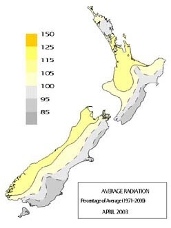
Sunshine and solar radiation totals were above average (about 110 percent of normal) in the west from Northland to Fiordland, as well as in Nelson. Duller than normal conditions prevailed in many eastern regions from Hawke’s Bay to Southland.
Highlights
Extreme temperatures
- The highest air temperature for the month was 26.6°C, recorded at Toenepi (southern Thames Valley) on the 16th. The highest April air temperature on record in that area is 27.8°C.
- The lowest air temperature for the month was –6.3°C, recorded at Tara Hills (Omarama) on the 25th, a new record low temperature extreme for April there in records going back to 1950.
High rainfall
- Significant rainfall (at least 50 mm) occurred throughout Nelson on the 5th, and in Bay of Plenty, the Gisborne high country, and Canterbury on the 6th. Widespread surface flooding was reported throughout Nelson after 20–30 mm of rain fell in an hour in the evening. Kawerau recorded torrential rainfall totalling 142.2 mm in 6 hours during the afternoon on the 6th, at rates up to 39 mm per hour. At Paengaroa (southeast of Te Puke) an unofficial rainfall total of 278 mm on the 6th was measured.
- High rainfall (over 100 mm in places) and surface flooding occurred in Northland and Coromandel townships on the 19th and 20th. At least 15 houses were affected in Coromandel township.
For further information, please contact:
Dr Jim Salinger – Principal Scientist, Climate NIWA National Climate Centre – Auckland Phone +64 9 375 2053 [email protected]
Stuart Burgess – Climatologist NIWA National Climate Centre – Wellington Phone +64 4 386 0569 [email protected]
Geoff Baird – Communications Manager Phone +64 4 386 0543 [email protected]
Acknowledgement of NIWA as the source is required.


