| Temperature | Temperatures were below average (0.51-1.20°C below average) for southwestern Waikato, Taranaki, Manawatū-Whanganui, Kāpiti Coast, Nelson, much of Marlborough, northeastern Canterbury, and parts of Central Otago. Temperatures were near average (±0.50°C of average) for most remaining parts of the country. |
| Rainfall | Rainfall was below normal (50-79% of normal) or well below normal (<50% of normal) for parts of every region. Rainfall was near normal (89-119% of normal) for much of Southland, Queenstown, Christchurch, Wellington, coastal Wairarapa, Hamilton, and Tauranga. Rainfall was above normal (120-149% of normal) in northern parts of Northland, Wairoa, Castlepoint, and Balclutha. |
| Soil Moisture | At the end of August, soil moisture levels were lower than normal for central parts of Hawke’s Bay. Soil moisture was higher than normal for eastern Hurunui, and eastern parts of Central Otago. Near normal soil moisture levels were typical for the remainder of the country. |
Overview
August 2025 mean sea level air pressure was higher than normal over and surrounding Aotearoa New Zealand, particularly over and to the west of the South Island. This was associated with more southeasterly winds than normal for the northern North Island, with prolonged periods of relatively fine, settled weather for much of the country. ENSO-neutral (El Niño – Southern Oscillation) conditions remained present in the tropical Pacific, but La Niña-like patterns became more established during the month. Sea surface temperatures (SSTs) around New Zealand were mostly above average, particularly off the west coast of the country with Marine Heatwave (MHW) conditions experienced in these areas.
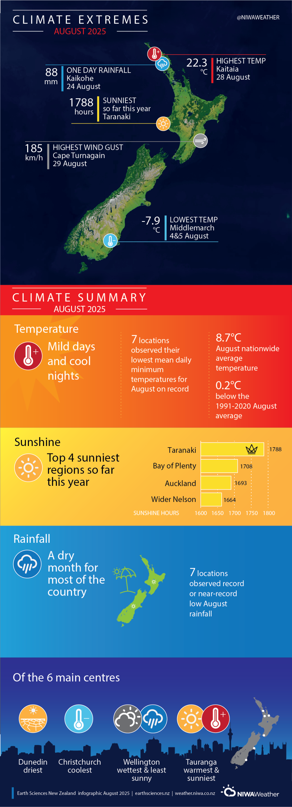
The nationwide average temperature in August 2025 was 8.7°C. This was 0.2°C below the 1991-2020 August average, making it New Zealand’s coolest month of winter 2025. It was a relatively cool month for southwestern Waikato, Taranaki, Manawatū-Whanganui, Kāpiti Coast, Nelson, much of Marlborough, northeastern Canterbury, and parts of Central Otago, where temperatures were below average (0.51-1.20°C below average). It was an especially cold August for Taumarunui and Ohakea, where temperatures were well below average (>1.20°C below average). Temperatures were mostly near average (±0.50°C of average) remaining areas of the country. The exception was Tauranga, southwestern Fiordland, and Stewart Island, where temperatures were above average (0.51-1.20°C above average).
It was a dry August for much of the country, and rainfall was below normal (50-79% of normal) or well below normal (<50% of normal) for parts of every region. Approximately 54% of New Zealand’s regularly reporting climate stations observed below normal or well below normal August rainfall. Near normal rainfall (89-119% of normal) occurred for much of Southland, Queenstown, Christchurch, Wellington, coastal Wairarapa, Hamilton, and Tauranga. Rainfall was above normal (120-149% of normal) in northern parts of Northland, Wairoa, Castlepoint, and Balclutha.
Further Highlights:
- The highest temperature was 22.3°C, observed at Kaitaia on 28 August.
- The lowest temperature was -7.9°C, observed at Middlemarch on 4 and 5 August.
- The highest 1-day rainfall was 88 mm, recorded at Kaikohe on 24 August.
- The highest wind gust was 185 km/h, observed at Cape Turnagain on 29 August.
- Of the six main centres in August 2025, Tauranga was the warmest and sunniest, Christchurch was the coolest, Wellington was the wettest and least sunny, and Dunedin was the driest.
- The sunniest four regions in 2025 so far are Taranaki (1788 hours), Bay of Plenty (1708 hours), Auckland (1693 hours) and wider Nelson (1664 hours).
Download