February dominated by a historic storm mid-month
| Temperature | Temperatures were well above average (>1.20°C above average) only in isolated parts of northwest Tasman. Above average temperatures (0.51–1.20°C above average) were recorded in Gisborne, Hawke’s Bay, and parts of Bay of Plenty, Coromandel, Auckland and Northland. Below average temperatures (0.51–1.20°C below average) occurred across Wellington and south Wairarapa, and substantial parts of the eastern and lower South Island. Elsewhere, near average temperatures (±0.50°C of average) prevailed in February. |
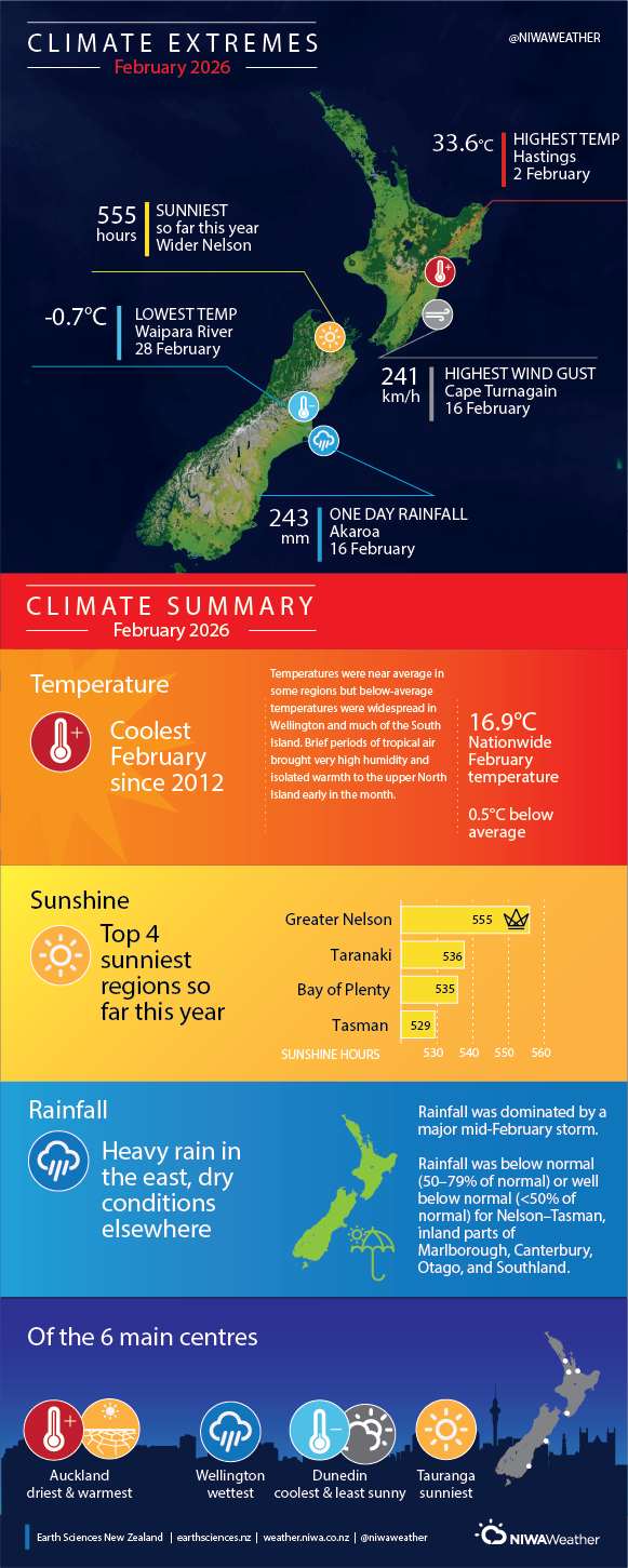
| Rainfall | Rainfall was well above normal (>149% of normal) across large parts of the eastern, central and southern North Island, pockets of eastern Northland, Banks Peninsula and parts of coastal Canterbury and Marlborough. Rainfall was above normal (120–149% of normal) for Fiordland and parts of coastal Otago. In contrast, rainfall was below normal (50–79% of normal) or well below normal (<50% of normal) for Nelson–Tasman, inland parts of Marlborough and Canterbury, Otago, and Southland. Elsewhere, near normal rainfall (80–119% of normal) occurred. |
| Soil Moisture | At the end of February, soil moisture levels were below normal in upper Northland, lower Manawatū, along the Kāpiti Coast, about eastern Nelson, and the Marlborough Sounds. Soil moisture levels were above normal for Banks Peninsula and other parts of eastern Canterbury and Marlborough, about Taupō, most of the eastern and lower North Island, as well as parts of Bay of Plenty, Waikato, and parts of eastern Northland. Near normal soil moisture levels were typical for the remainder of the country. |
Overview
February will be remembered for the “Valentine’s Storm” – a low-pressure system originating in the subtropics which deepened dramatically as it stalled near and to the east of the country in the middle of the month. Another low-pressure system with more limited impacts opened the month, and these two depressions dominate the overall monthly pressure anomaly. However, in between these systems there were some prolonged periods of settled weather over New Zealand. La Niña conditions continued through most of the month of February, but were approaching ENSO-neutral by the end of the month. Sea surface temperatures (SSTs) surrounding New Zealand were extremely variable during the month, exhibiting warming trends during settled periods only to cool dramatically in response to unsettled weather, especially around the middle of the month. At the end of February, Marine Heatwave (MHW) conditions[1] were absent from New Zealand coastal waters, but a broad and significant MHW persisted in the subtropical waters to our northeast. This MHW originated in November and continued to influence our weather on occasions during February.
The nationwide average temperature in February 2026 was 16.9°C. This was 0.5°C below the 1991-2020 February average, and it was the coolest February since 2012.
The month started with tropical air moving over the northern half of the country, with the highest air temperatures and dew point temperatures of the month recorded during this period. Cold air moved onto New Zealand in the wake of the two low pressure systems, leading to some notably low daytime temperatures in eastern parts of the country.
Overall, February featured lower than normal air pressures directly over the country. However, this anomaly only represents the most significant weather systems of the month, obscuring the fact that there were several periods of slow-moving high pressure systems over New Zealand. This resulted in rainfall that was dramatic in intensity and fell on a relatively small number of days in the month (“boom or bust” rainfall patterns). Rainfall was above average or well above average for areas exposed to these two significant weather systems – areas in the east of both islands, and the central North Island.
Further Highlights:
- The highest temperature was 33.6°C, observed at Hastings on 2 February.
- The lowest temperature was -0.7°C, observed at Waipara River North Branch on 28 February.
- The highest 1-day rainfall was 243 mm, recorded at Akaroa on 16 February.
- The highest wind gust was 241 km/h, observed at Cape Turnagain on 16 February.
- Of the six main centres, Tauranga was the sunniest, Auckland was the driest and warmest, Wellington was the wettest, and Dunedin was the coolest and least sunny.
- The sunniest four regions in 2026 so far are wider Nelson (555 hours), Taranaki (536 hours), Bay of Plenty (535 hours), and Tasman (529 hours).
[1] Defined as five or more consecutive days with SSTs above the 90th percentile for the time of year.
