A cyclone and a low dominate the picture
| Temperature | Temperatures were well above average (>1.20°C well above average) for isolated spots in Canterbury, Southland, Otago, Buller and Tasman. Above average temperatures (0.51-1.20°C above average) were recorded for much of the North Island, as well as most of the eastern, upper and lower South Island. Near normal temperatures (±0.50°C) occurred elsewhere. |
| Rainfall | Rainfall was well above normal (>149% of normal) for almost the entire North Island, and coastal Marlborough. Rainfall was above normal (120-149% of normal) for some central parts of the North Island, the Far North, South Canterbury and southern Westland. Rainfall was below normal (50-79% of normal) or well below normal (<50% of normal) for Tasman, parts of Southland, the remainder of Canterbury, Buller and much of Otago. Near normal rainfall (80-119% of normal) was reported in the rest of the South Island, parts of Gisborne and Bay of Plenty. |
| Soil Moisture | At the end of April, soil moisture levels were lower than normal in parts of Canterbury and Otago. Soil moisture levels were higher than normal across the majority of the North Island, eastern Marlborough, South Canterbury and Clutha. Near normal soil moisture levels were typical for the remainder of the country. |
Overview
April 2026 continued the theme of the year, as slow-moving high pressure systems alternated with significant depressions. The first of these was Cyclone Vaianu, a highly compact and unusually intact system of tropical origins in the middle of the month, closely followed by a much broader and more complex low pressure system only one week later. This second system had more widespread impacts which lasted over several days. The final week of the month saw a return to settled conditions under another broad and slow moving anticyclone. The overall monthly anomaly comprised higher than normal air pressure to the east of the country, and lower than normal air pressure just west of the country, leading to a northeasterly circulation anomaly over New Zealand.
Sea Surface Temperature (SSTs) remained warmer than normal around most coastal waters, with the exception of the eastern North Island where colder than normal waters persisted. ENSO (El Niño Southern Oscillation) neutral conditions continued through the month, though La Niña-like weather patterns persisted despite the demise of the recent La Niña event.
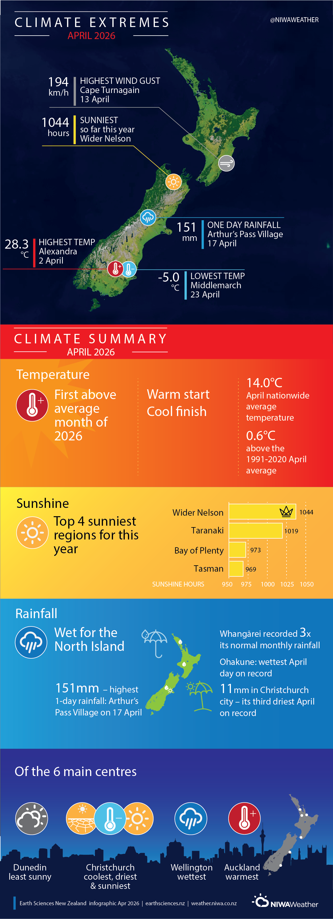
The nationwide average temperature in April 2026 was 14.0°C. This is 0.6°C above the 1991-2020 April average.
The nationwide rainfall pattern was highly dependent on Cyclone Vaianu and the broad low pressure system that followed a week later. This created a distinctive rainfall anomaly for the month, where some locations received significant rainfall amounts from the systems in succession, while others – sometimes quite nearby – received little to nothing. The North Island in general saw widespread and heavy rainfall from these two systems, with corresponding wet anomalies for the month, whereas the South Island was not affected so widely, leading to converse anomalies sitting in close proximity. For example, Cape Campbell received more than five times its typical April rainfall, whereas Christchurch reported a fraction of its norm: its third driest April on record.
Further highlights
- The highest temperature was 28.3°C, observed at Alexandra on 2 April.
- The temperature was -5.0°C, observed at Middlemarch 23 April.
- The highest 1-day rainfall was 151 mm, recorded at Arthur’s Pass Village on 17 April.
- The highest wind gust was 194 km/h, observed at Cape Turnagain on 13 April.
- Of the six main centres in April 2026, Auckland was the warmest, Wellington was the wettest, Christchurch was the coolest, driest, and sunniest, and Dunedin was the least sunny.
- The sunniest four regions in 2026 so far are wider Nelson (1044 hours), Taranaki (1019 hours), Bay of Plenty (973 hours) and Tasman (969 hours).