An unsettled close to 2025
| Temperature | Temperatures were well above average (>1.20°C above average) for Northland, Auckland, much of the Coromandel, the east coast of the North Island, and western Tasman. Above average temperatures (0.51-1.20°C above average) were recorded elsewhere in the North Island, as well as in parts of Canterbury and Marlborough. Below average temperatures (0.51-1.20°C below average) occurred in much of Fiordland and interior Otago, with near normal temperatures (±0.50°C) elsewhere. |
| Rainfall | Rainfall was well above normal (>149% of normal) or above normal (120-149% of normal) for coastal Otago, Fiordland, most of the Canterbury low country, Marlborough south of Blenheim, South Taranaki, the Wellington region, most of Hawke’s Bay, and Gisborne. Rainfall was below normal (50-79% of normal) or well below normal (<50% of normal) for Nelson-Tasman, parts of southern Southland, much of the West Coast, the Bay of Plenty, eastern Waikato, and Northland. Elsewhere, near normal rainfall (80-119% of normal) fell in December. |
| Soil Moisture | At the end of December, soil moisture levels were lower than normal in upper Northland, lower Manawatū, along the Kāpiti Coast, about Nelson, in Southland about Invercargill, about North Otago and South Canterbury, and parts of the high country of Canterbury. Soil moisture levels were higher than normal along the west coast of the North Island from Auckland to Taranaki, about Taupō, along the east coast of the North Island, western Tasman, the upper West Coast, most of Fiordland, Balclutha, and portions of coastal Canterbury and Marlborough. Near normal soil moisture levels were typical for the remainder of the country. |
Overview
December was an unsettled month, with alternating hot and cool spells, and a wet end to the month for many areas.
Overall, lower than average air pressure dominated over Aotearoa New Zealand in December. Additionally, after a record setting November, December was much closer to average temperature-wise, although with an overall warm lean. La Niña conditions continued through the month of December and the impacts of a sudden stratospheric warming event from early spring continued to wane. Sea surface temperatures (SSTs) surrounding New Zealand were mostly above average, however the SST anomalies eased in the latter half of the month in response to additional clouds and increased windiness across New Zealand’s waters.
At the end of December, Marine Heatwave (MHW) conditions[1] were present about the west coast of Northland, the Auckland, Waikato, and Bay of Plenty areas in the North Island and near the coasts of Southland, Stewart Island, and most of the east coast of the South Island.
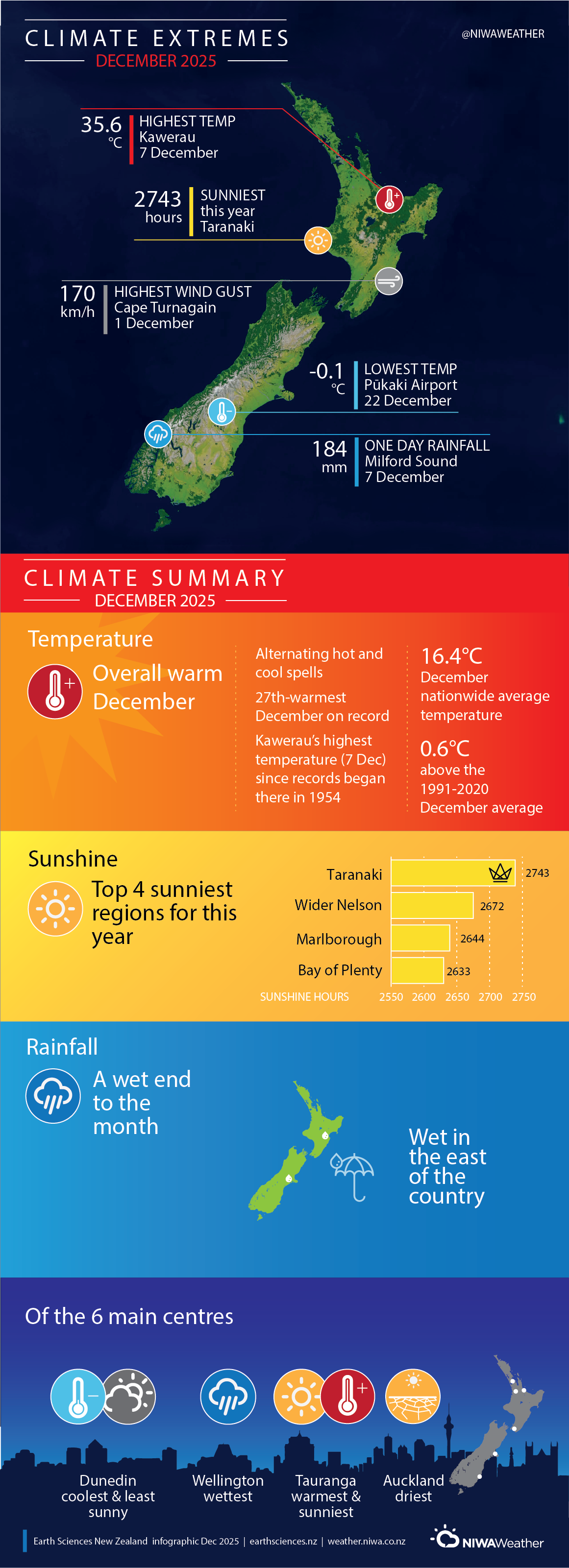
The nationwide average temperature in December 2025 was 16.4°C. This is 0.6°C above the 1991-2020 December average, making it New Zealand’s 27th- warmest December on record.
The month featured brief unsettled periods with cooler weather, with a long stretch of warm and dry weather for the early to middle of the month across the North Island. Meanwhile, the South Island remained somewhat cooler and unsettled overall. The last half of the month featured alternating cooler and warmer air masses, followed by a slow moving northerly low pressure system that brought warm moisture laden air to the North Island and the upper South Island in the final days of December.
While December featured lower than average air pressures overall, the month was filled with alternating periods of high pressure and low pressure, which led to an uneven distribution of rainfall across the country. Rainfall was well above normal (>149% of normal) for coastal Otago, Fiordland, most of the Canterbury low country south of Christchurch, the east of the Wellington region, and the east of Hawke’s Bay and Gisborne, with above normal (120-149% of normal) rainfall in Marlborough south of Blenheim, Canterbury about Kaikōura, South Taranaki, and the rest of the Wellington region. The rainfall for the east of the North Island was notable since these areas were very dry until the final days of December. Rainfall was below normal (50-79% of normal) for Nelson-Tasman, parts of southern Southland, much of the West Coast, the Bay of Plenty, eastern Waikato, and most of Northland, with the Far North recording well below normal (<50% of normal) rainfall. Elsewhere, near normal rainfall (80-119% of normal) fell in December.
Further Highlights:
- The highest temperature was 35.6°C, observed at Kawerau on 7 December. Notably, this was Kawerau’s highest temperature since records began there in 1954.
- The lowest temperature was -0.1°C, observed at Pūkaki Airport 22 December.
- The highest 1-day rainfall was 184 mm, recorded at Milford Sound on 7 December.
- The highest wind gust was 170 km/h, observed at Cape Turnagain on 1 December.
- Of the six main centres in December 2025, Tauranga was the warmest and sunniest, Wellington was the wettest, Dunedin was the coolest and least sunny, and Auckland was the driest.
- The sunniest four regions in 2025 were Taranaki (2743 hours), wider Nelson (2672 hours), Marlborough (2644 hours), and Bay of Plenty (2633 hours).
[1] Defined as five or more consecutive days with SSTs above the 90th percentile for the time of year.
