A weekly update describing soil moisture patterns across the country to show where dry to extremely dry conditions are occurring or imminent. Regions experiencing significant soil moisture deficits are deemed “hotspots”. Persistent hotspot regions have the potential to develop into drought.
Recent rainfall and current soil moisture conditions:
In the North Island, over the last seven days rainfall amounts of 30 to 50 mm were observed in most of the Wellington region, parts of the Manawatū, portions of the Auckland region, the foothills and ranges of Hawke’s Bay, Bay of Plenty, the Waikato, and about Taranaki. A few locations about Taranaki Maunga and the Central Plateau recorded 50 to 100 mm of rain, with the remainder of the North Island generally recording 10 to 30 mm over the last seven days. Soil moisture decreased across Northland, Auckland, the Waikato, the Bay of Plenty, Gisborne, most of Hawke’s Bay and coastal parts of the Wairarapa. A moderate increase in soil moisture was observed in the southern Manawatū and the remainder of the Wairarapa and Wellington region. Elsewhere, soil moisture remained the same or saw a slight increase. The wettest soils for the time of year across the North Island, when compared to normal, are located in Gisborne. The driest soils, when compared to normal for the time of year, are found in the Far North.
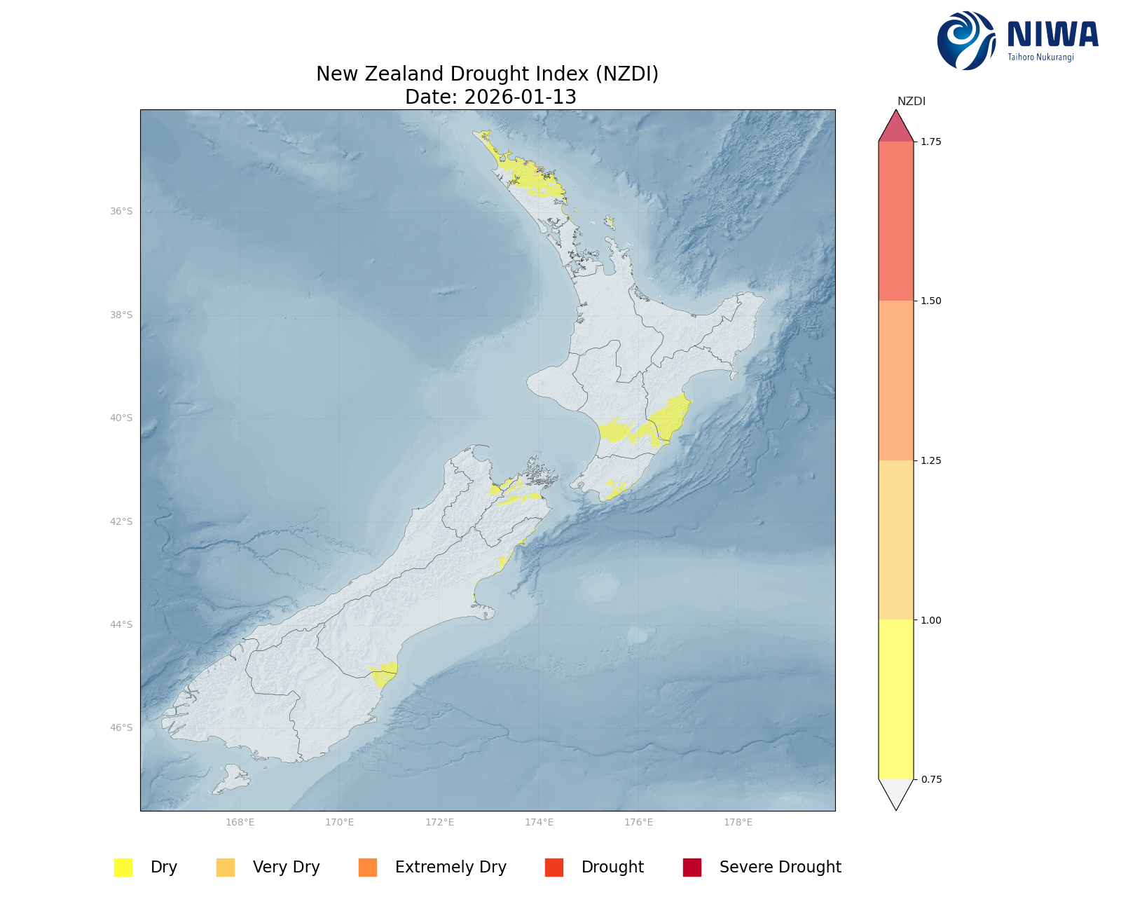
There is a hotspot in Northland from Kaikohe northward. The previous hotspots near Whanganui, in southern Hawke’s Bay, and in the Wairarapa have dissipated. As of 13 January, the New Zealand Drought Index (NZDI) map shows that abnormally dry conditions are currently found in southern Hawke’s Bay, lower Wellington, southern Manawatū, and Northland, with very dry conditions about the Bay of Islands in Northland.
In the South Island, coastal Westland, western Tasman district, about the Marlborough Sounds, the Canterbury high country, North Canterbury about Kaikoura, coastal Southland, and small portions of Otago received 30 to 50 mm of rain over the last seven days, with higher terrain locations in the west of the South Island recording 50 to 100 mm of rain. 100 to 200 mm of rain was recorded in Fiordland and in the Southern Alps. The remainder of the South Island generally recorded 10 to 30 mm of rain. Soil moisture remained the same across most of Otago and southern Canterbury. Otherwise, soil moisture saw slight to moderate increases across the remainder South Island over the past week. The driest soils in the South Island, when compared to normal for the time of year, are located about Oamaru in North Otago, while the wettest soils for the time of the year are found in the western Tasman District about Collingwood.
The previous hotspots in the South Island have all dissipated. As of 13 January, the New Zealand Drought Index (NZDI) map shows that abnormally dry conditions are currently found in small parts of coastal Canterbury and North Otago, about Nelson City, and the Wairau Valley in Marlborough.
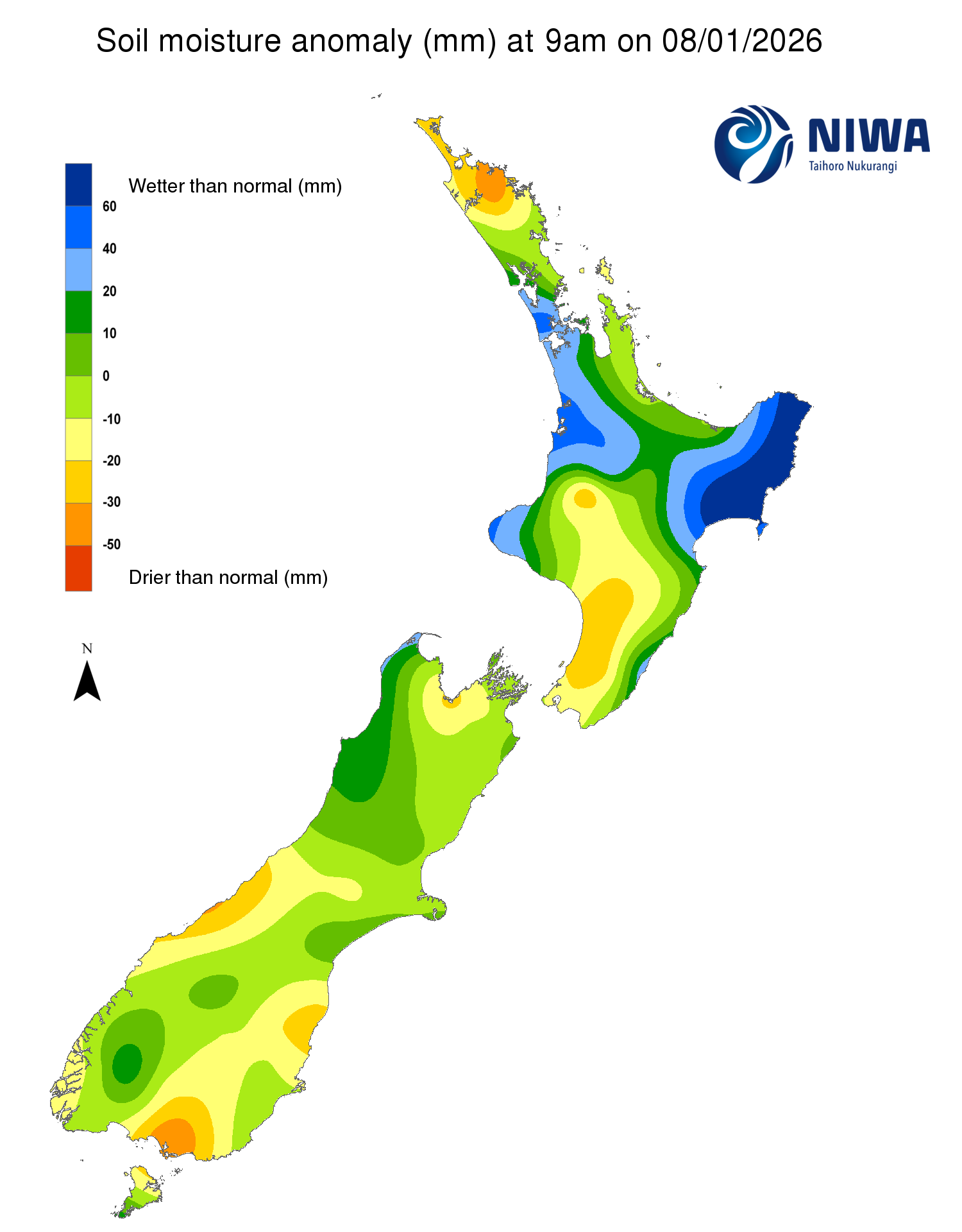
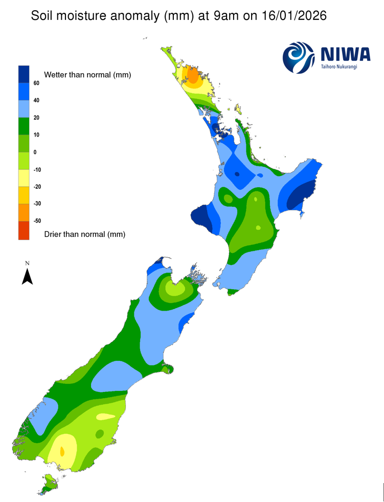
Pictured above: Soil Moisture Anomaly Maps, relative to this time of year. The maps show soil moisture anomalies over the past two weeks.
New Zealand Drought Index (NZDI)
As of 13 January, the New Zealand Drought Index (NZDI) map shows that abnormally dry conditions are currently found in small parts of coastal Canterbury and North Otago, about Nelson City, the Wairau Valley in Marlborough, southern Hawke’s Bay, lower Wellington, southern Manawatū, and Northland, with very dry conditions about the Bay of Islands in Northland.
Please note: some hotspots in the text above may not correspond with the NZDI map. This difference exists because the NZDI uses additional dryness indices, including one which integrates the rainfall deficit over the past 60 days. Changes are therefore slower to appear in the NZDI compared to soil moisture anomaly maps that are instantaneously updated.
The week ahead:
In the North Island, low pressure will be moving away to the southeast on Friday evening, with westerly flow replacing the low, leading to drier conditions on Saturday. Isolated showers are forecast for the weekend (17-18 January), followed by easterly flow developing over the top of the North Island and southeasterly winds for the remainder of the North. The easterly wind flow and a developing low pressure system will bring potential heavy rain to Northland, with periods of showers and rain in the Auckland region and the Coromandel Peninsula from Monday through Thursday. Elsewhere, expect light showers in the east of the North Island from Sunday through Friday (18-23 January). Weekly rainfall totals of 50 to 75 mm are expected for Northland, with isolated locations in the east and along the ranges seeing up to 100 mm of rain. Weekly rainfall totals of 30 to 50 mm are expected about Auckland, the Coromandel Peninsula, for the ranges and foothills in Bay of Plenty, Gisborne, and Hawke’s Bay. The remainder of the North Island is forecast to receive 10 to 30 mm of rain over the next seven days.
Due to the expected rainfall in the next week, a slight to moderate decrease of soil moisture is possible for the lower North Island, Taranaki, the Manawatū, the Waikato (except for the Coromandel), southern Hawke’s Bay, and the lower elevations of the Bay of Plenty, with soil moisture expected to increase or remain the same for the remainder of the North Island. The current hotspot in Northland will likely dissipate over the next week. There is a slight chance that hotspots may form in the Manawatū, across southern Hawke’s Bay, and the Wellington region.
In the South Island, the departing low pressure will leave a southerly wind flow, allowing for a few showers across the island, especially in the east of the South from Friday night through Monday morning. Otherwise, high pressure will be near or over the South Island for much of the week, with few rain opportunities through Thursday morning (22 January). Thursday afternoon and Friday a cold front will move across the South Island with light to moderate rain for the west and the south of the island. Weekly rainfall totals of 10 to 30 mm of rain are expected for the Canterbury high country and about Kaikoura, and the foothills about Nelson, Marlborough, and the Tasman districts. Elsewhere, expect less than 10 mm of rain over the next week, with parts of the west of the South Island recording little to no rain.
Due to the expected rainfall in the next week, soil moisture levels will decrease or remain the same across the entire South Island, with the largest decreases likely for the West Coast, Southland, and Otago. A hotspot may re-form in North Otago, with new hotspots possibly developing across South Canterbury, Southland, and near Nelson and Richmond in the Tasman District.
Long-term outlook (through mid-February):
- The drier (25th percentile) scenario shows normal or below normal rainfall across the majority of New Zealand, with very dry conditions for the west and the south of the South Island and about Auckland and Northland, and wet to very wet conditions in the upper South Island and lower North Island. In this scenario, dry soil conditions may emerge in the western and lower South Island.
- The middle (50th percentile) rainfall scenario shows normal rainfall conditions for the North Island except for the Wellington region, dry to very dry conditions for the west and south of the South Island, and wet to very wet conditions in the upper South Island, lower North Island, and North Canterbury.
- In the wetter (75th percentile) scenario, wetter than normal conditions are signalled for a majority the North Island, the upper South Island, and a majority of Canterbury, with a dry lean for the west and south of the South Island.
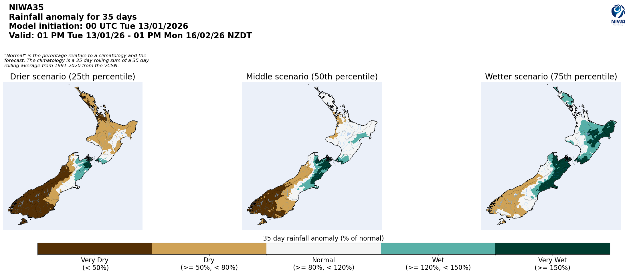
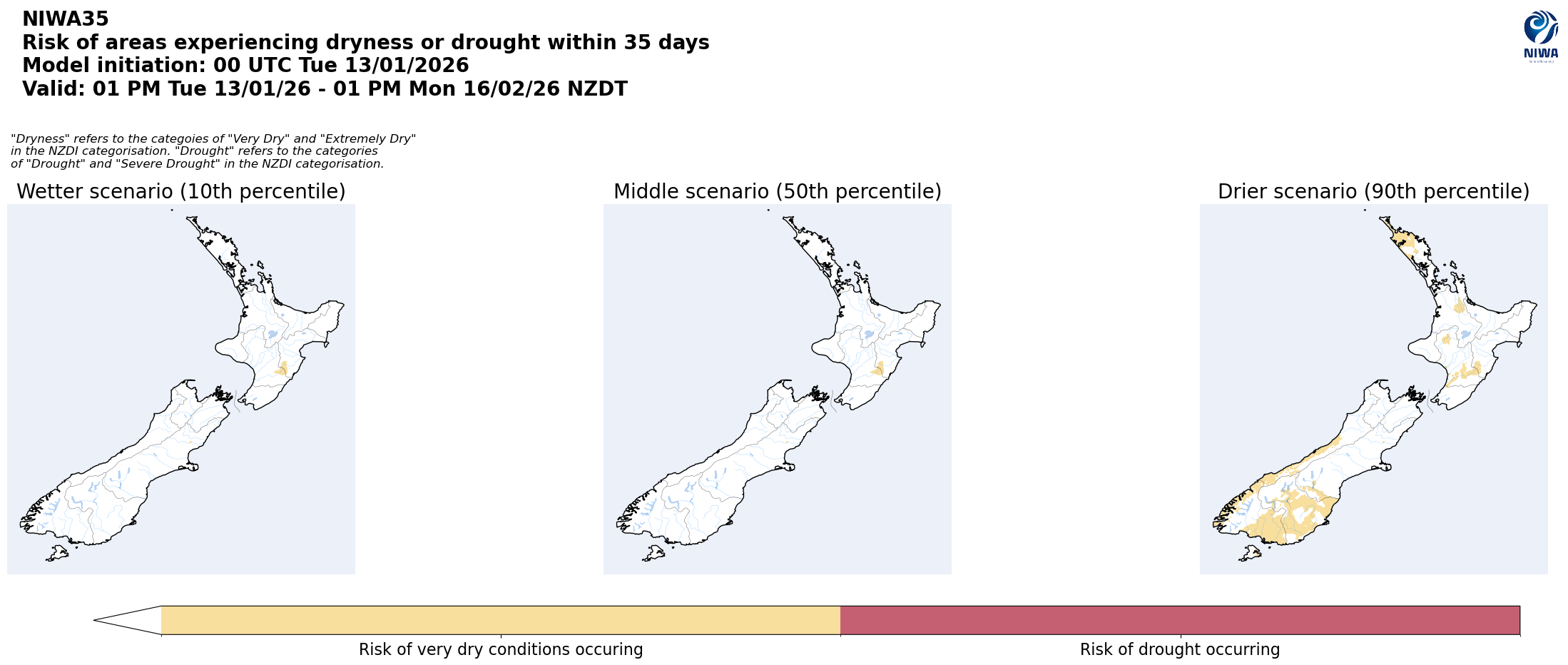
Pictured above: 35-day forecast rainfall anomaly scenarios (Top), and 35-day forecast dryness and drought scenarios (Bottom). These maps are updated daily at https://niwa.co.nz/climate/seasonal-climate-outlook
Background:
Hotspot Watch: a weekly advisory service for New Zealand media. It provides soil moisture and precipitation measurements around the country to help assess whether extremely dry conditions are imminent.
Soil moisture deficit: the amount of water needed to bring the soil moisture content back to field capacity, which is the maximum amount of water the soil can hold.
Soil moisture anomaly: the difference between the historical normal soil moisture deficit (or surplus) for a given time of year and actual soil moisture deficits.
Definitions: “Extremely” and “severely” dry soils are based on a combination of the current soil moisture status and the difference from normal soil moisture (see soil moisture maps at https://www.niwa.co.nz/climate/nz-drought-monitor/droughtindicatormaps)
Hotspot: A hotspot is declared if soils are "severely drier than normal" which occurs when Soil Moisture Deficit (SMD) is less than -110 mm AND the Soil Moisture Anomaly is less than -20 mm.