A weekly update describing soil moisture patterns across the country to show where dry to extremely dry conditions are occurring or imminent. Regions experiencing significant soil moisture deficits are deemed “hotspots”. Persistent hotspot regions have the potential to develop into drought.
Recent rainfall and current soil moisture conditions:
In the North Island, 50 to 75 mm of rain was recorded over the last seven days about Taranaki Maunga, the Kaimai Range and the Bay of Plenty just west of Tauranga, Bay of Plenty east of Whakatane, Gisborne just west of East Cape, and in the Manawatū about Tongariro. Generally 30 to 50 mm of rain fell across most of the Waikato including the southern part of the Coromandel Peninsula, southern Auckland, the Bay of Plenty excluding Rotorua, northern Gisborne, southern Hawke’s Bay, remainder of Taranaki, majority of the Manawatū, and most of the Wairarapa. Eastern and northern Northland recorded less than 10 mm of rain over the last week, with the remainder of the North Island generally recorded 10 to 30 mm of rain. A large decrease of soil moisture has been observed in the Far North, with a moderate to small decrease in soil moisture about the central North Island including the foothills of the Bay of Plenty, in lower Welington, and about Wanganui and surrounding parts of the Manawatū. Elsewhere, in the remainder of the North Island soil moisture remained the same or decreased slightly. The driest soils, when compared to normal for the time of year, are found around Cape Reinga, with the wettest soils, when compared to normal for the time of year, are found about eastern Northland, Auckland, the Waikato, the western Bay of Plenty, Gisborne, coastal Hawke’s Bay, and Taranaki.
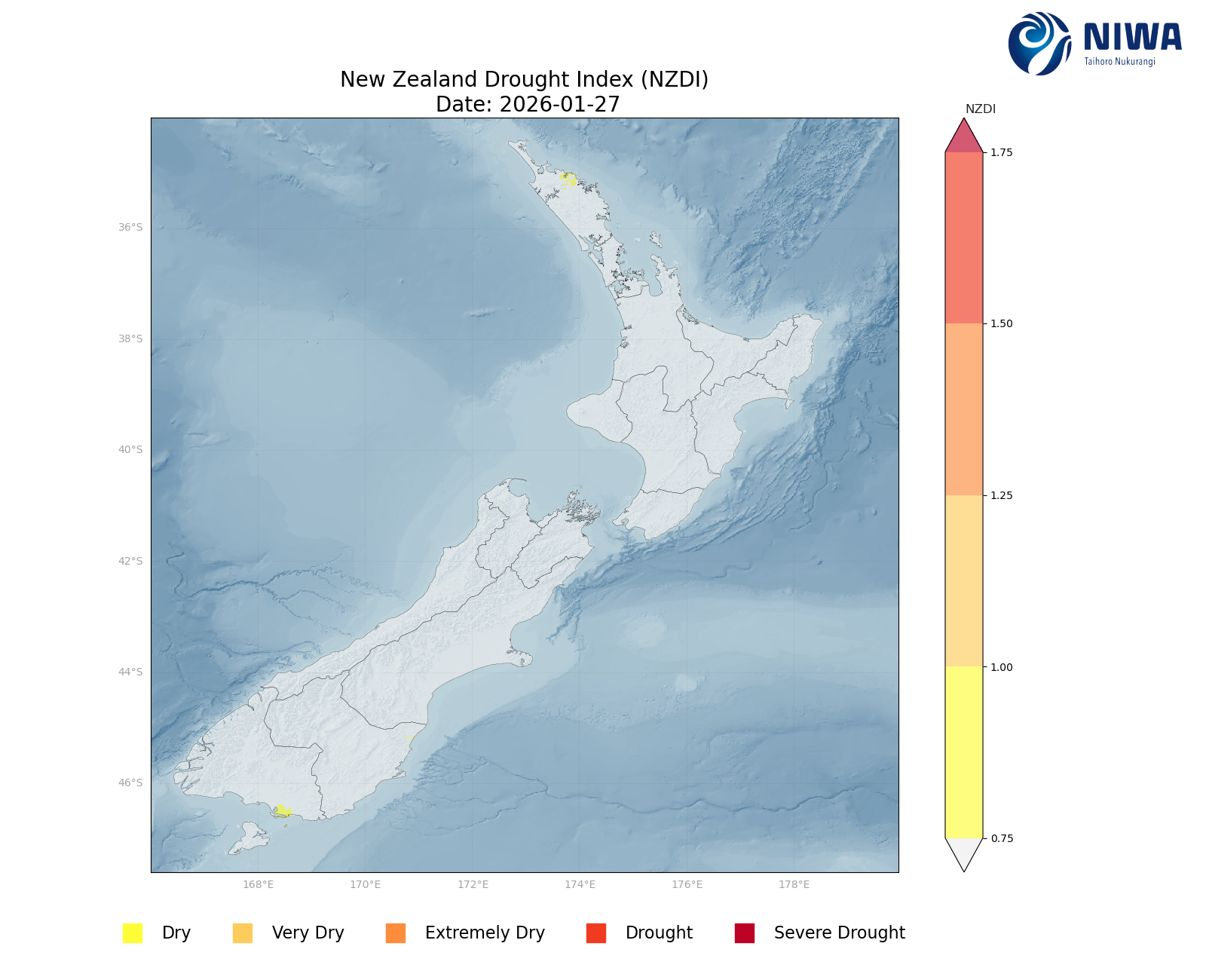
A hotspot has re-formed in the Far North at Cape Reinga. As of 27 January, the New Zealand Drought Index (NZDI) map shows that abnormally dry conditions are currently found in the Bay of Islands in Northland.
In the South Island, weekly rainfall totals of 50 to 100 mm were recorded in coastal North Canterbury north of Amberley, most of Banks Peninsula, in northern Westland about Karamea and Reefton, and in pockets of Otago and Southland primarily about mountains and foothills. Elsewhere, 30 to 50 mm of rain fell across the remainder of Southland, most of coastal Otago, much of Canterbury, Westland north of Haast to Westport, the remainder of Tasman, and about Marlborough excluding the Marlborough Sounds. The remainder of the South Island generally recorded 10 to 30 mm of rain over the past week. Soil moisture increased across Southland, Otago, Canterbury, and northern Westland. Elsewhere, soil moisture saw a moderate decrease in the Marlborough Sounds and south Tasman, with a large decrease in soil moisture for Fiordland and Westland about and south of Hokitika. For the remainder of the South Island, soil moisture generally remained the same. The driest soils in the South Island, when compared to normal for the time of year, are in coastal Fiordland and lower Westland, while the wettest soils for the time of the year are found in the western Tasman District, Canterbury north of Waipara, and Marlborough about and south of Seddon.
The previous hotspot in Southland has dissipated. As of 27 January, the New Zealand Drought Index (NZDI) map shows that abnormally dry conditions are currently found about Bluff in Southland.
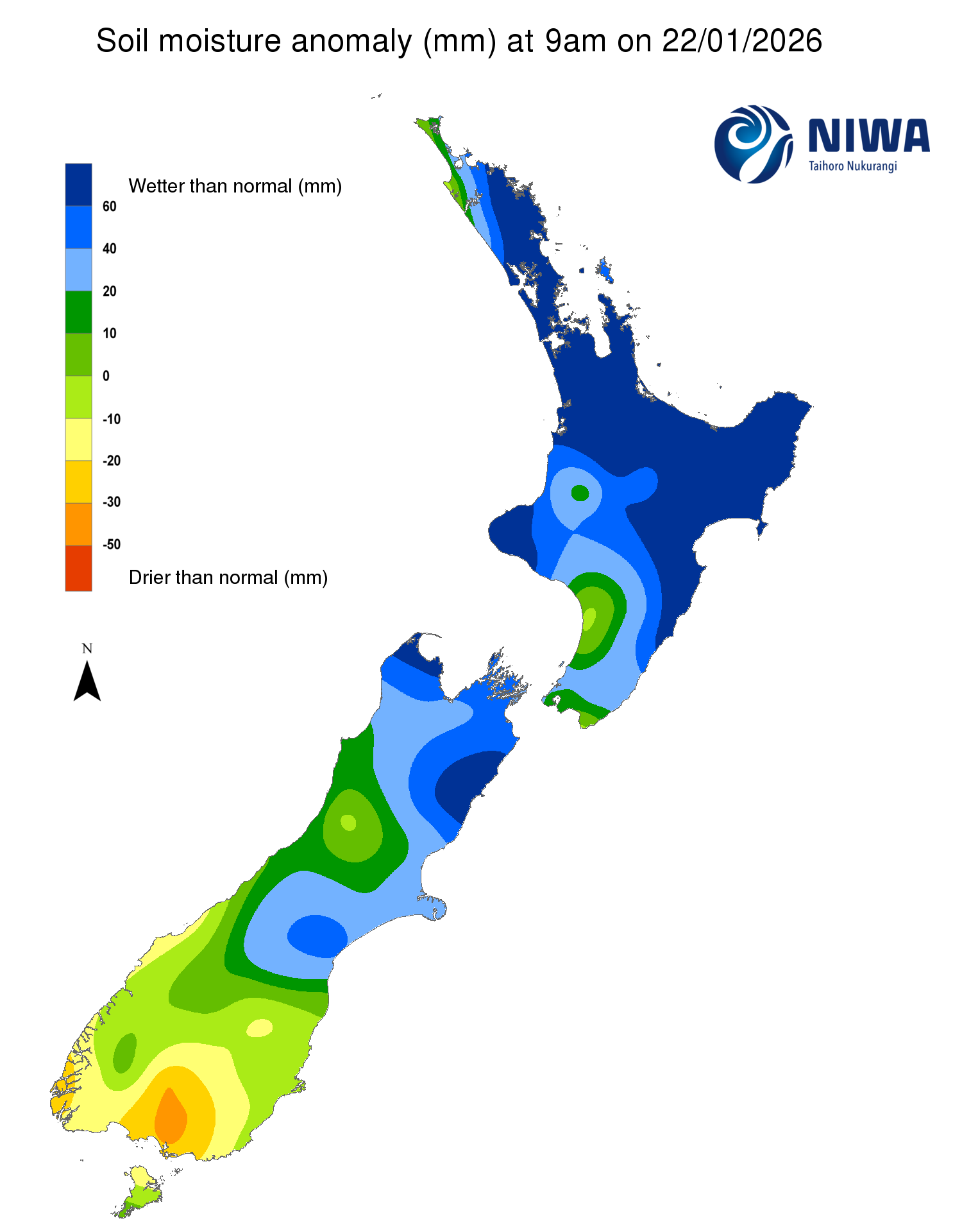
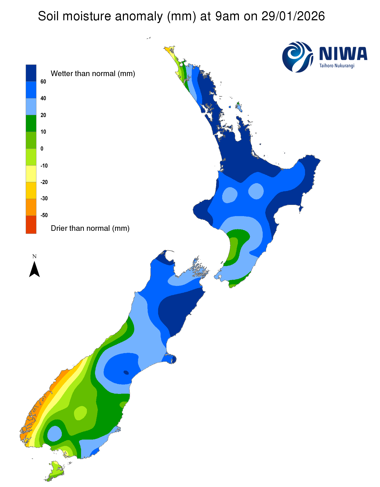
Pictured above: Soil Moisture Anomaly Maps, relative to this time of year. The maps show soil moisture anomalies over the past two weeks.
New Zealand Drought Index (NZDI)
As of 27 January, the New Zealand Drought Index (NZDI) map shows that abnormally dry conditions are currently found about Bluff in Southland and the Bay of Islands in Northland.
Please note: some hotspots in the text above may not correspond with the NZDI map. This difference exists because the NZDI uses additional dryness indices, including one which integrates the rainfall deficit over the past 60 days. Changes are therefore slower to appear in the NZDI compared to soil moisture anomaly maps that are instantaneously updated.
The week ahead:
In the North Island, generally settled weather is expected over the next week. On Friday (30 January) high pressure will move across the island and remain in place through to early Monday morning. A northwesterly wind flow and a southwesterly change (cold front) will bring a few showers Monday and Tuesday, heaviest in the west and south of the island. High pressure will move back in for Wednesday and Thursday, with a somewhat moist easterly wind flow expected across the north of the North Island. Expected rainfall over the next week will generally range from 10 to 30 mm for much of the North Island, except in Gisborne, Hawke’s Bay, and the Wairarapa where less than 10 mm of rain is likely.
Due to the expected rainfall in the next week, soil moisture levels will likely see a moderate decrease for all of the North Island. The hotspot about Cape Reinga in Northland will likely strengthen and expand.
In the South Island, high pressure will replace a southerly wind flow on Friday, with generally light sea breeze winds through Saturday evening. Northerly winds develop on Sunday, followed by a cold front that brings a southwest wind change later Sunday into Monday. This will lead to a period of rain, heaviest in the west and south of the South Island. The front clears early Tuesday morning, leaving mostly dry and cool southwesterly winds ahead of the next area of high pressure, which moves out of the Tasman Sea and across the island on Wednesday (4 February). On Thursday, showers will return to the west of the South Island with a northwesterly wind flow. Weekly rainfall totals of 30 to 50 mm of rain are expected for Westland and western Southland, with higher amounts of 50 to 100 mm about the Southern Alps. For the remainder of Southland, Otago, and the Canterbury High Country expect 20 to 40 mm of rain, with Nelson, Marlborough, and northern and central Canterbury likely to receive under 10 mm of rain over the next week.
Due to the expected rainfall in the next week, soil moisture levels will remain the same or increase slightly across western Southland, Stewart Island, and the foothills of the Southern Alps in Otago and Westland. Elsewhere, the remainder of the South Island will see moderate decreases in soil moisture.
Long-term outlook (through early-March):
- The drier (25th percentile) scenario is indicating widespread below normal rainfall across all of the country, with very dry conditions for the east and north of the South Island, and very dry conditions for the Wairarapa and the west and north of the North Island.
- The middle (50th percentile) scenario shows dry conditions for nearly all of the South Island and for Gisborne and the west and south of the North Island, with near normal conditions elsewhere.
- In the wetter (75th percentile) scenario, wetter than normal conditions are signalled for the east and north of the North Island, particularly for Hawke’s Bay and Gisborne, with near normal rainfall elsewhere in the North and South Islands.
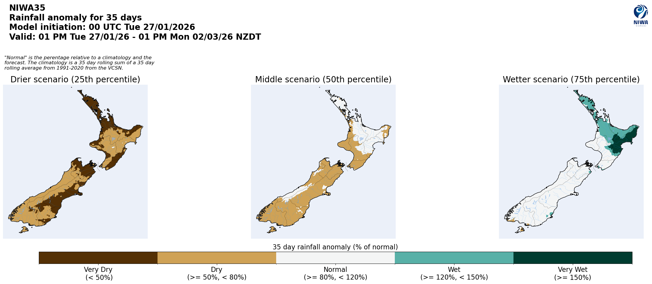
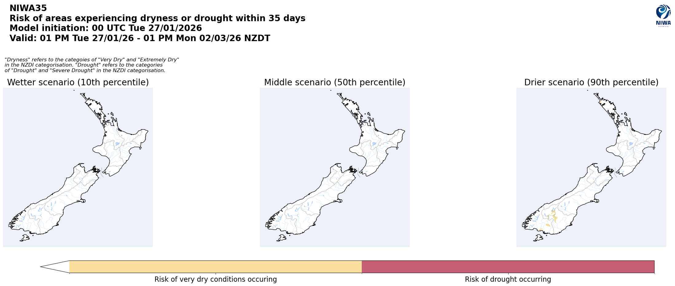
Pictured above: 35-day forecast rainfall anomaly scenarios (Top), and 35-day forecast dryness and drought scenarios (Bottom). These maps are updated daily at https://niwa.co.nz/climate/seasonal-climate-outlook
Background:
Hotspot Watch: a weekly advisory service for New Zealand media. It provides soil moisture and precipitation measurements around the country to help assess whether extremely dry conditions are imminent.
Soil moisture deficit: the amount of water needed to bring the soil moisture content back to field capacity, which is the maximum amount of water the soil can hold.
Soil moisture anomaly: the difference between the historical normal soil moisture deficit (or surplus) for a given time of year and actual soil moisture deficits.
Definitions: “Extremely” and “severely” dry soils are based on a combination of the current soil moisture status and the difference from normal soil moisture (see soil moisture maps at https://www.niwa.co.nz/climate/nz-drought-monitor/droughtindicatormaps)
Hotspot: A hotspot is declared if soils are "severely drier than normal" which occurs when Soil Moisture Deficit (SMD) is less than -110 mm AND the Soil Moisture Anomaly is less than -20 mm.