A month with long dry spells and late season warmth
|
Rainfall |
Large areas of well below normal rainfall (<50% of normal) or below normal rainfall (50-79% of normal) were observed across much of the northern and eastern North Island and the eastern South Island. The only areas that received above normal rainfall (120-149% of normal) were parts of Waikato, Taranaki, western Manawatū-Whanganui, northern West Coast, northern Tasman and northern Marlborough. Small parts of these regions (mostly mountainous and coastal areas) recorded well above normal rainfall (>149% of normal). Near normal rainfall (80-119% of normal) was observed in the west/east divide straddling these districts, as well as in much of Wellington, Westland and coastal Fiordland. |
|
Temperature |
Temperatures were above average (0.50-1.20°C above average) or well above average (>1.20°C above average) in parts of Northland, Auckland, inland Waikato, eastern Hawke’s Bay and the Wairarapa and Tararua districts, as well as across most of the South Island excluding the northeast. The rest of New Zealand experienced near average temperatures (±0.50°C of average). |
|
Soil Moisture |
At the beginning of April, soil moisture levels were lower than normal for this time of year for the northern and eastern North Island, and eastern, central and southern South Island. Above normal soil moisture were observed in parts of Waikato, Taranaki, western Manawatū-Whanganui, parts of Wellington, northern Marlborough, Nelson, parts of Tasman and Fiordland. The remainder of New Zealand had near normal soil moisture levels. |
Overview
During March, La Niña began its transition to ENSO-neutral. The SOI (Southern Oscillation Index) was neutral and sea surface temperature anomalies increased in the central equatorial Pacific.
March was characterised by a strong mid-month ridge of high pressure across Aotearoa New Zealand and a weaker than normal jet stream in the Tasman Sea and Southwest Pacific, contributing to unusual dryness. This was associated with the suppressed phase of the Madden-Julian Oscillation, a climate driver, over the Pacific Ocean.
New Zealand’s coastal water temperature anomalies increased during March with substantially warmer than average sea surface temperatures east of the South Island. Pockets of marine heatwave conditions were observed in the Far North, coastal Canterbury, and coastal Southland, extending east of the country.
There was a clear west to east divide of rainfall during March in New Zealand. As a result, the majority of New Zealand experienced below normal rainfall (50-79% of normal) or well below normal rainfall (<50% of normal) during March. Infrequent cold fronts brought showers and rain to western areas, particularly the West Coast, while east of the ranges on the South Island and much of the North Island remained drier. Parts of Gisborne, Hawke’s Bay, Wellington, Canterbury and Otago recorded at least 25 dry days (0.1 mm or less) during March. However, during 27-31 March, a scattered thunderstorm outbreak brought about by the combination of humid northeasterlies and an upper cold pool resulted in some parts of the western North Island receiving heavy downpours. This brief period of wet weather was responsible for above normal (120-149% of normal) and pockets of well above normal (>150% of normal) rainfall for parts of the Waikato, Taranaki, western Manawatū-Whanganui, northern West Coast, northern Tasman and northern Marlborough.
Temperatures for the month of March were above average for large parts of the South Island, with the exception of the northeast, and parts of the North Island, particularly for inland Waikato and east of the ranges. Some parts of Canterbury and Hawke’s Bay even experienced the odd day of temperatures in excess of 30°C. The rest of New Zealand experienced near average temperatures overall (±0.50°C of average).
Further Highlights:
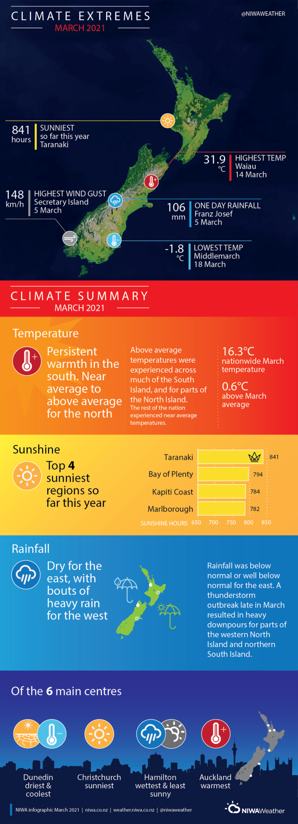
- The highest temperature was 31.9°C, observed at Waiau on 14 March.
- The lowest temperature was -1.8°C, observed at Middlemarch on 18 March.
- The highest 1-day rainfall was 106 mm, recorded at Franz Josef on 5 March.
- The highest wind gust was 148 km/h, observed at Secretary Island on 5 March.
- Of the six main centres in March 2021, Auckland was the warmest, Christchurch was the sunniest, Dunedin was the coolest and driest, and Hamilton was the wettest and least sunny.
- Of the available, regularly reporting sunshine observation sites, the sunniest four locations so far in 2021 are Taranaki (841 hours), Bay of Plenty (794 hours), Kāpiti Coast (784 hours) and Marlborough (782 hours).
- The mean temperature for March 2021 was 16.3°C which is 0.6°C warmer than normal (1981-2010).


