A weekly update describing soil moisture patterns across the country to show where dry to extremely dry conditions are occurring or imminent. Regions experiencing significant soil moisture deficits are deemed “hotspots”. Persistent hotspot regions have the potential to develop into drought.
Recent rainfall and current soil moisture conditions:
In the North Island, 30 to 50 mm of rain fell about the foothills of Taranaki, small portions of Manawatū and the Waikato about Taumarunui, about Mount Tongariro, the Bay of Plenty east of Opotiki, and along the foothills of the Tararua Range in the Wairarapa. Elsewhere, generally 10 to 30 mm of rain was recorded for the remainder of the Wellington region, northern Manawatū, remainder of Taranaki, and the Waikato about Tokoroa. The remainder of the North Island recorded less than 10 mm of rain over the past seven days. A moderate to large soil moisture increase has been observed in lower Wellington and in Northland about Cape Reinga and North Cape. Soil moisture remained the same about Wellington and the northern Waikato. Elsewhere, the North Island experienced a small to moderate decrease in soil moisture over the past week. The driest soils, when compared to normal for the time of year, are found along the Northland coast west of Kaitaia, with the wettest soils, when compared to normal for the time of year, are found about Auckland, the western Waikato and western Coromandel Peninsula, Hawke’s Bay about Wairoa, Taranaki about Opunake, and about Wellington city and the eastern Wellington region.
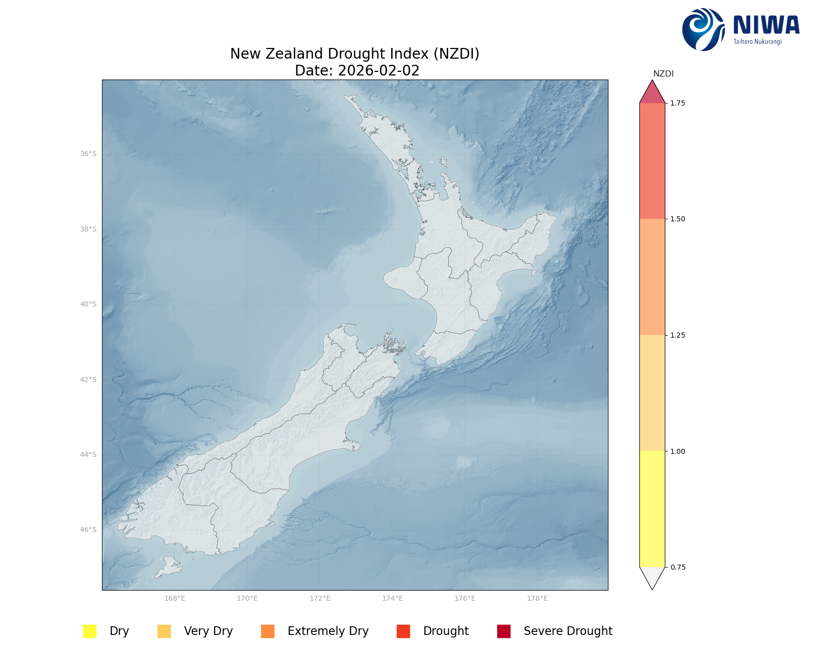
There are currently no hotspots in the North Island. As of 2 February, the New Zealand Drought Index (NZDI) map shows no abnormally dry conditions anywhere across New Zealand.
In the South Island, weekly rainfall totals of 30 to 50 mm were recorded across the Tasman district west of Richmond, the Marlborough Sounds, much of the Canterbury high country, Westland south of Fox Glacier, and a majority of Fiordland, with pockets of 50 to 100 mm about Fiordland, lower Westland, and about Tākaka in Tasman. Over the last week less than 10 mm fell across most of Otago east of Queenstown and north of Balclutha. The remainder of the South Island generally recorded 10 to 30 mm of rain over the past week. A small to moderate soil moisture increase occurred for the Marlborough Sounds and western Tasman. Soil moisture saw a moderate to large decrease in Southland including Stewart Island, Westland south of Westport, and Otago. For the remainder of the South Island, soil moisture generally remained the same. The driest soils in the South Island, when compared to normal for the time of year, are in coastal Fiordland and lower Westland, about Bluff in Southland, and on Stewart Island, while the wettest soils for the time of the year are found in the western Tasman District, Canterbury north of Waipara, and Marlborough about and south of Seddon.
There is an existing hotspot in Southland about Bluff, a new hotspot has developed west of Alexandra along the Otago and Southland border. As of 2 February, the New Zealand Drought Index (NZDI) map shows no abnormally dry conditions anywhere across New Zealand.
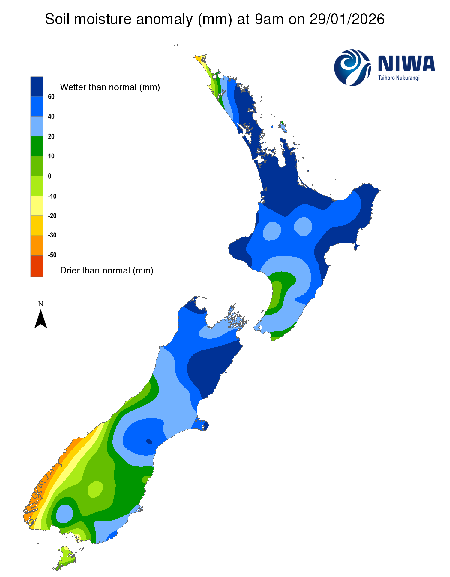
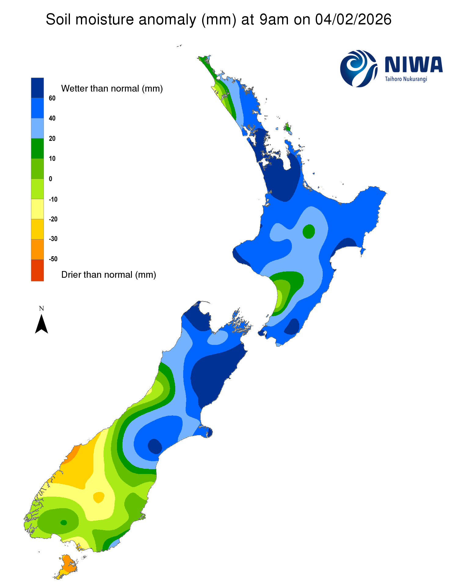
Pictured above: Soil Moisture Anomaly Maps, relative to this time of year. The maps show soil moisture anomalies over the past two weeks.
New Zealand Drought Index (NZDI)
As of 2 February, the New Zealand Drought Index (NZDI) map shows no abnormally dry conditions are currently found anywhere in New Zealand.
Please note: some hotspots in the text above may not correspond with the NZDI map. This difference exists because the NZDI uses additional dryness indices, including one which integrates the rainfall deficit over the past 60 days. Changes are therefore slower to appear in the NZDI compared to soil moisture anomaly maps that are instantaneously updated.
The week ahead:
In the North Island, generally settled weather is expected over the next week. On Friday (6 February) high pressure moves off to the east and a front moves in from the southwest and dissipates over the lower North Island. High pressure rebuilds over the Tasman Sea on Saturday and lingers over or around the North Island through Wednesday (11 February). Weak fronts will occasionally move in from the southwest with little impact. In this period, aside from a few showers, the North Island will remain dry. East to northeasterly wind flow sets up for next week Thursday and Friday, allowing for additional rain showers across the North Island. Expected rainfall over the next week will generally be less than 10 mm of rain for the North Island, except for some foothills and mountain locations where up to 30 mm of rain may fall.
Due to the expected rainfall in the next week, soil moisture levels will likely see a moderate to large decrease for all of the North Island. A hotspot may emerge in the Far North in Northland.
In the South Island, a weak front moves across the lower South Island early Friday, followed by another front late Saturday into Sunday, resulting in some rain across the south and west of the island. From Sunday through Tuesday (8 to 10 February), high pressure will bring mostly settled weather, though showers are still possible Monday and Tuesday. A moist, northerly wind flow next Wednesday and Thursday brings an opportunity for rain again in the west and south of the South Island. Weekly rainfall totals of 30 to 50 mm of rain are expected for southern Westland and Southland from Invercargill westward and Steward Island, with higher amounts of 50 to 150 mm about the Southern Alps. For the remainder of Southland, western Otago, and the remainder of Westland expect 10 to 30 mm of rain, with higher amounts in the foothills. The remainder of the South Island is likely to receive less than 10 mm of rain over the next week.
Due to the expected rainfall in the next week, soil moisture levels will remain the same or increase slightly across western Southland, Stewart Island, and lower Westland. Elsewhere, the remainder of the South Island will see moderate to large decreases in soil moisture.
Long-term outlook (through early-March):
- The drier (25th percentile) scenario is indicating widespread below normal rainfall across all of the country, with very dry conditions for the south of the South Island.
- The middle (50th percentile) scenario shows dry conditions for west and south of the South Island, with near normal conditions elsewhere across New Zealand.
- In the wetter (75th percentile) scenario, wetter than normal conditions are signalled for the south, east, and north of the North Island, and the north and east of the South Island, with potential for very wet conditions in Northland, Auckland, the Waikato, Bay of Plenty, Hawke’s Bay, Gisborne, Marlborough, and North Canterbury, and dry conditions for the south of the South Island.
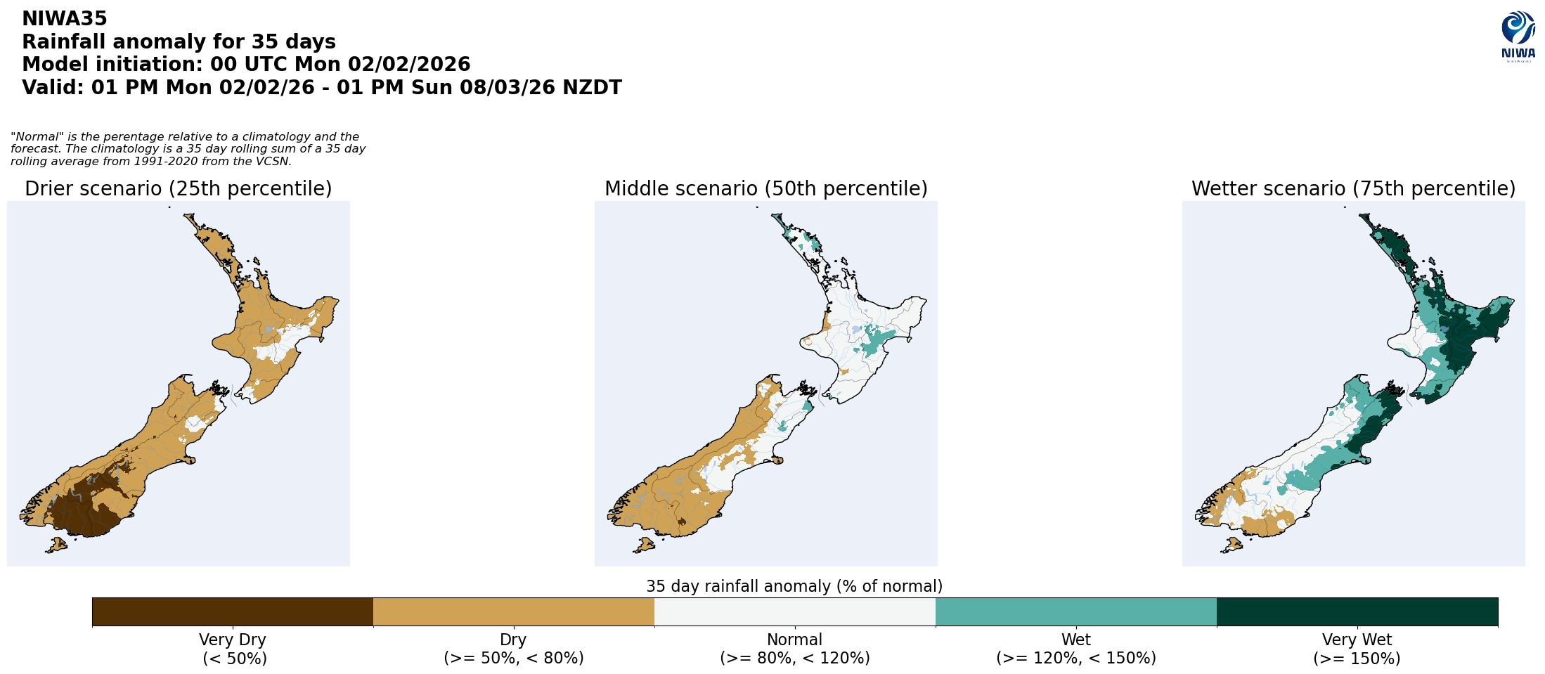
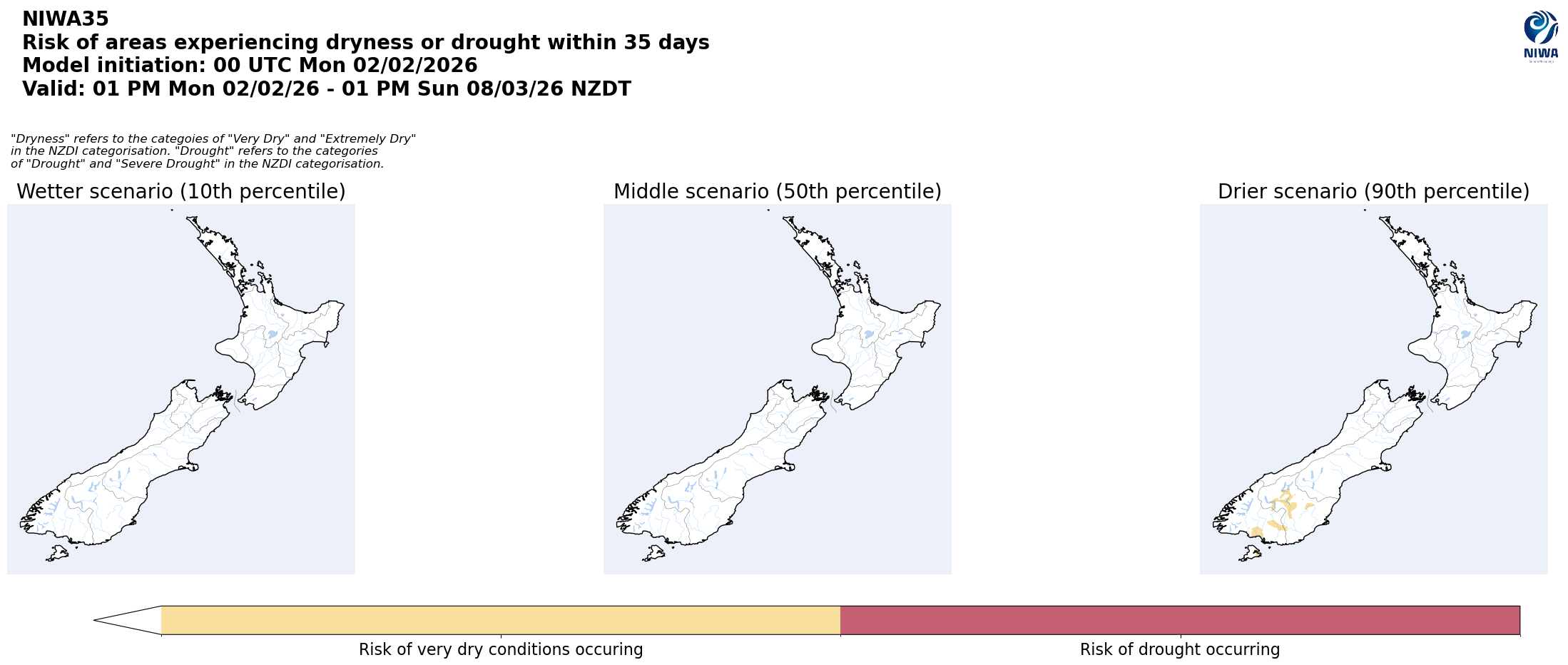
Pictured above: 35-day forecast rainfall anomaly scenarios (Top), and 35-day forecast dryness and drought scenarios (Bottom). These maps are updated daily at https://niwa.co.nz/climate/seasonal-climate-outlook
Background:
Hotspot Watch: a weekly advisory service for New Zealand media. It provides soil moisture and precipitation measurements around the country to help assess whether extremely dry conditions are imminent.
Soil moisture deficit: the amount of water needed to bring the soil moisture content back to field capacity, which is the maximum amount of water the soil can hold.
Soil moisture anomaly: the difference between the historical normal soil moisture deficit (or surplus) for a given time of year and actual soil moisture deficits.
Definitions: “Extremely” and “severely” dry soils are based on a combination of the current soil moisture status and the difference from normal soil moisture (see soil moisture maps at https://www.niwa.co.nz/climate/nz-drought-monitor/droughtindicatormaps)
Hotspot: A hotspot is declared if soils are "severely drier than normal" which occurs when Soil Moisture Deficit (SMD) is less than -110 mm AND the Soil Moisture Anomaly is less than -20 mm.