Overview
| Temperature | Temperatures were well above average (>1.20°C above average) for most of the country, while temperatures were above average (0.51°C to 1.20°C above average) for eastern parts of Canterbury near Christchurch. |
| Rainfall | Rainfall was above normal (120-149% of normal) or well above normal (>149% of normal) for northern parts of the North Island, Taranaki, western Wellington, northern parts of the South Island, eastern Canterbury, and Central Otago. Below normal (50-79% of normal) or well below normal (<50% of normal) rainfall was observed in Gisborne, Hawke’s Bay, Whanganui, Wairarapa, Dunedin, South Otago and southeastern Southland. |
| Soil Moisture | At the end of April, soil moisture levels were below normal for parts of Waikato, southern Taranaki, Whanganui, Hawke’s Bay, Wairarapa, South Otago and about Invercargill. Soil moisture levels were above normal or well above normal in Northland, Auckland, Bay of Plenty, East Cape, Nelson, Marlborough, and much of Canterbury. Soil moisture levels were generally near normal elsewhere. |
April 2025 was characterised by lower than normal mean sea level pressure (MSLP) to the northwest of Aotearoa New Zealand, and higher than normal MSLP to the east of the country. This produced more northeasterly airflows than normal, bringing sustained warm temperatures and several heavy rain events over the course of the month. This included the arrival of ex-tropical cyclone Tam around mid-April, which caused flooding, power outages and coastal erosion for parts of Northland, Auckland, Coromandel, and the Bay of Plenty (see Highlight and extreme events section for more details).
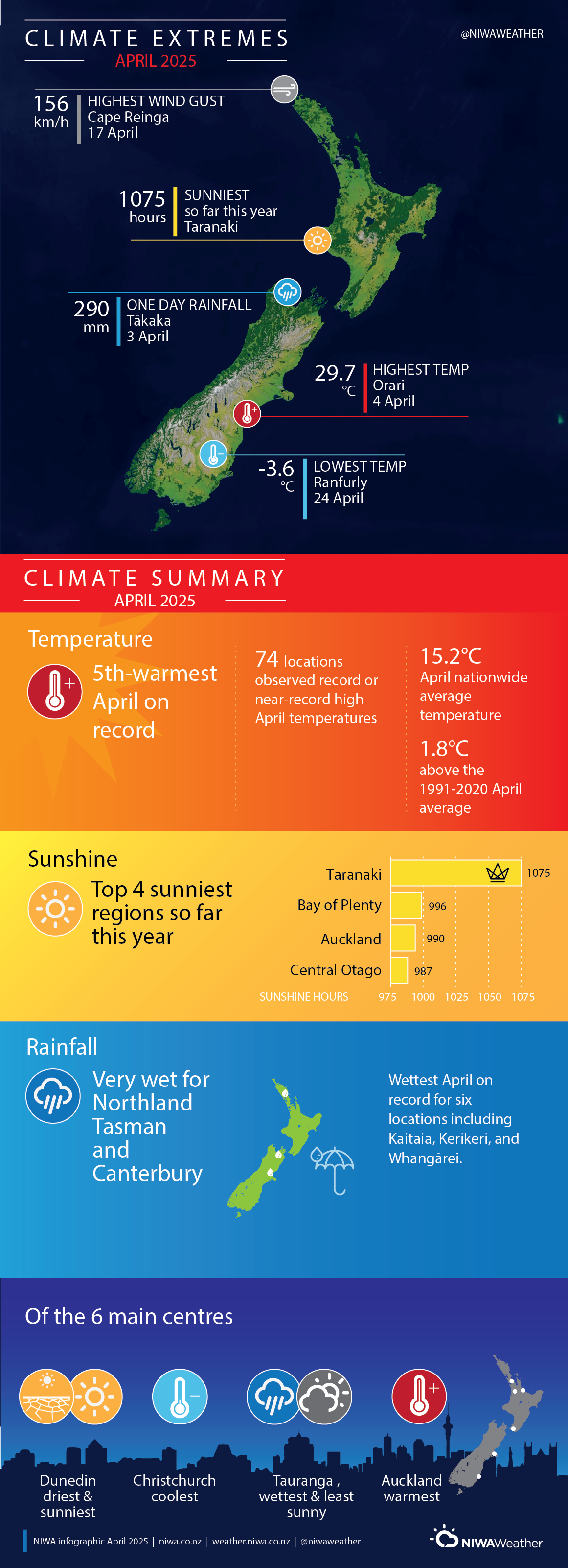
Temperatures were well above average (>1.20°C above average) in every region of the country, with above average temperatures (0.51°C to 1.20°C above average) for eastern parts of Canterbury near Christchurch. Several periods of exceptional warmth resulted in summer-like temperatures in many areas, and dozens of locations observed record or near-record high daily maximum and minimum temperatures for April. The nationwide average temperature in April 2025 was 15.2°C. This was 1.8°C above the 1991-2020 April average from NIWA’s seven station temperature series which begins in 1909, making it New Zealand’s 5th-warmest April on record.
Rainfall was above normal (120-149% of normal) or well above normal (>149% of normal) for Northland, Auckland, Coromandel, Bay of Plenty, much of Taranaki, western Wellington, Tasman, Nelson, northern West Coast, Marlborough, eastern Canterbury, and parts of Central Otago. In contrast, below normal (50-79% of normal) or well below normal (<50% of normal) rainfall was observed in Gisborne, Hawke’s Bay, Whanganui, Wairarapa, Dunedin, South Otago and southeastern Southland. Near normal rainfall (80-119% of normal) was observed elsewhere.
Further highlights
- The highest April temperature was 29.7°C, observed at Orari on 4 April.
- The lowest April temperature was -3.6°C, observed at Ranfurly on 24 April.
- The highest 1-day rainfall was 290 mm, recorded at Tākaka on 3 April.
- The highest wind gust was 156 km/h, observed at Cape Reinga on 17 April.
- Of the six main centres in April 2025, Auckland was the warmest, Christchurch was the coolest, Dunedin was the driest and sunniest, and Tauranga was the wettest and least sunny.
- The sunniest four regions so far in 2025 are Taranaki (1075 hours), Bay of Plenty (996 hours), Auckland (990 hours), and Central Otago (987 hours).
Download