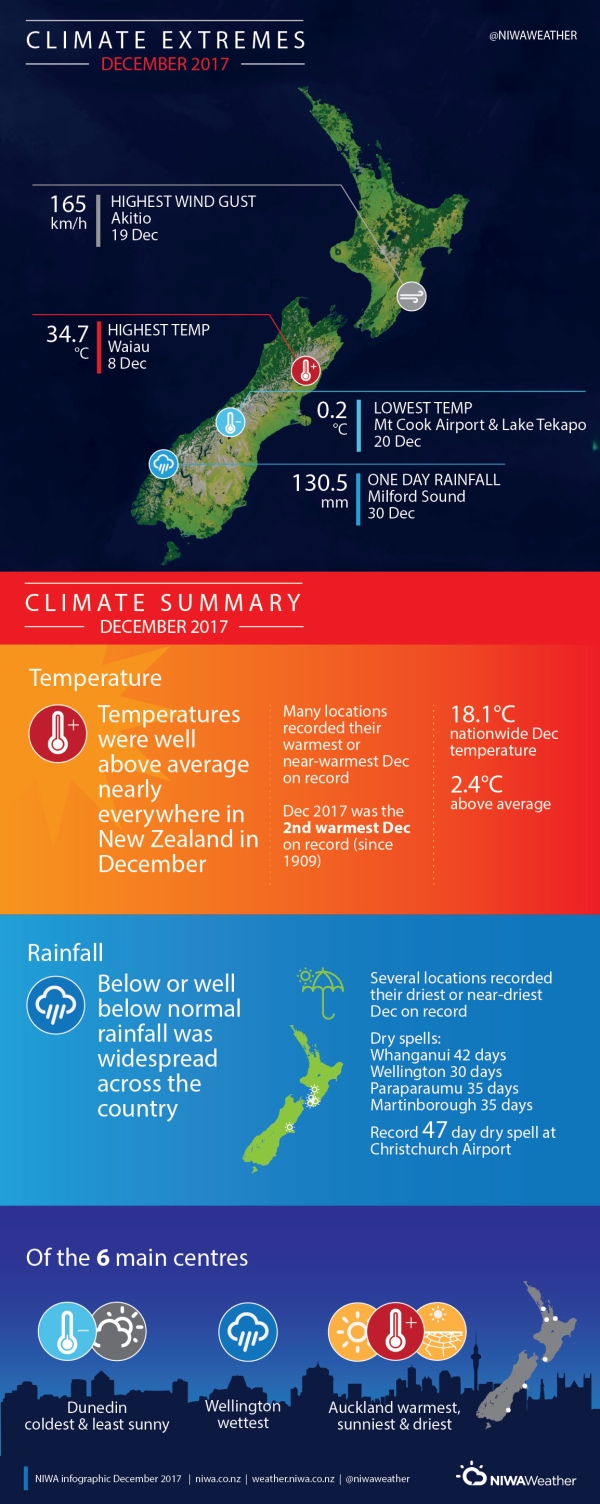
A very warm and dry month
Overview
December 2017 was characterised by higher than normal sea level pressure over New Zealand and the surrounding seas. This pressure setup, consistent with La Niña conditions, resulted in long periods of dry, settled, and very warm weather across the country throughout the month.
Below normal (50-79% of normal) or well below normal (<50% of normal) rainfall was commonplace for large swaths of New Zealand in December, a product of the higher than normal sea level pressure entrenched across the country. In fact, a large number of locations observed either their lowest or near-lowest December rainfall on record. This included Auckland Airport, which recorded only 8 mm of rain (9% of its December normal), its driest December since records began in 1959. It was also the driest December on record at Paraparaumu Airport since 1945, with only 15 mm recorded. In fact, Paraparaumu experienced a 35-day dry spell that ended on 13 December.
Due to the widespread dry conditions, soil moisture levels continued to run below or well below normal for the time of year across much of the country. At the end of December the driest soils compared to normal for the time of year were found from Northland to Taranaki, Horowhenua, Kapiti Coast, Tasman to interior Canterbury, and southern Southland.
The persistence of higher than normal pressure also resulted in well above average (>1.20°C of average) temperatures nearly everywhere in New Zealand. This was further enhanced by sea surface temperatures (SSTs) in New Zealand coastal waters and the Tasman Sea that continue to run well above average. SSTs were generally 1 to 3°C above average for the time of year and up to 6°C above average in some parts of the Tasman Sea. A plethora of locations around the country recorded either their warmest or near-warmest December on record. Notably, this included Nelson, which observed its warmest December since records began in 1862, Levin, with records dating to 1895, and Ranfurly, which had its warmest December since 1897.
Further Highlights:
- The highest temperature was 34.7°C, observed at Waiau on 8 December.
- The lowest temperature was 0.2°C, observed at Mt Cook (Airport) and Lake Tekapo on 20 December.
- The highest 1-day rainfall was 130.5 mm, recorded at Milford Sound on 30 December.
- The highest wind gust was 165 km/h, observed at Akitio on 19 December.
- Of the six main centres in December 2017, Auckland was the warmest, sunniest, and driest, Dunedin was the coldest and least sunny, and Wellington was the wettest.
Contact:
Seth Carrier, Meteorologist Tel. 09 375 4508
Download:
- December 2017 Climate Summary information [PDF 600KB]
- December 2017 Climate statistics [PDF 90KB]
Details
|
Rainfall |
Rainfall was below normal (50-79% of normal) or well below normal (<50% of normal) for large swaths of New Zealand, including Northland, Auckland, Waikato, Bay of Plenty, Taranaki, coastal Manawatu-Whanganui to Wellington, Nelson, Tasman, interior Canterbury, much of the West Coast, Otago, and parts of Southland. Meanwhile, isolated pockets of near normal (80-119% of normal) to above normal (120-149% of normal) rainfall was observed from coastal Hawke’s Bay to Wairarapa, coastal northern and southern Canterbury, and Fiordland. |
|
Temperature |
Temperatures were well above average (>1.20°C of average) nearly everywhere in New Zealand. Isolated above average (0.51-1.20°C of average) temperatures were observed in Gisborne, inland Hawke’s Bay, and a small area of the Far North. |
|
Soil Moisture |
As of 1 January, soils were significantly drier than normal for the time of year across a large portion of the North Island, Tasman and northern West Coast, interior Canterbury, and much of Southland and interior Otago. Soil moisture was slightly below normal to near normal for much of coastal Canterbury and Otago. Meanwhile, near normal to above normal soil moisture was observed along the east coast of the North Island, coastal Marlborough, and Westland to Fiordland. |

