A weekly update describing soil moisture patterns across the country to show where dry to extremely dry conditions are occurring or imminent. Regions experiencing significant soil moisture deficits are deemed “hotspots”. Persistent hotspot regions have the potential to develop into drought.
Recent rainfall and current soil moisture conditions:
In the North Island, rainfall amounts of 100 to 150 mm generally fell across the Bay of Plenty, eastern Waikato and the Coromandel Peninsula in the past week, with localised amounts of 200 mm or more in the Bay of Plenty. Elsewhere, 50 to 100 mm generally fell across southern Northland, Auckland, the remainder of Waikato, Taranaki, upper portions of Manawatū-Wanganui, and the foothills of Hawke’s Bay and Gisborne. Generally under 30 mm of rain fell across Wellington, coastal Hawke’s Bay, and the Far North. Elsewhere, 30 to 50 mm generally fell across the North Island. Soil moisture levels generally increased substantially in Northland, Auckland, the Waikato, Taranaki, the Bay of Plenty, and northern Manawatū, with the rest of the North Island seeing a slight decrease or little change in soil moisture. The driest soils across the North island, when compared to normal for this time of year, are found in coastal Hawke’s Bay and lower Wairarapa, while the wettest soils for this time of year are found in Northland, Auckland, the Coromandel Peninsula, and western Bay of Plenty.
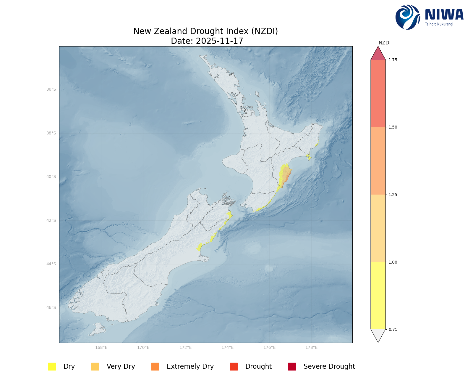
The hotspot located in coastal Hawke’s Bay has weakened somewhat in the past week and the hotspot in Gisborne has dissipated. Meanwhile, lower coastal Wairarapa may be approaching hotspot status. As of 17 November, the New Zealand Drought Index (NZDI) map shows that abnormally dry and very dry conditions are currently found in southern portions of Hawke’s Bay, with a small area of extremely dry conditions right at the coast of Hawke’s Bay.
In the South Island, much of the West Coast, Fiordland and western Tasman districts received 50 to 100 mm of rain in the past seven days, with 200 mm or more in the high terrain of the West Coast. Conversely, the majority of Southland, Otago, South Canterbury, and Marlborough recorded a meagre 30 mm or less, with some portions of Otago, Canterbury, and Southland recording no rain. Elsewhere, the South Island generally recorded 30 to 50 mm of rain. Soil moisture increased across the northern half of the South Island, with the greatest increase in Banks Peninsula, North Canterbury, Marlborough, and Nelson-Tasman. Meanwhile, soil moisture decreased across parts of South Canterbury, Otago, and Southland. Elsewhere, soil moisture remained the same. The driest soils in the South Island, when compared to normal for this time of year, are in coastal South Canterbury and western Southland. The wettest soils for this time of year are found in interior Otago and the northwest Tasman district.
A hotspot has formed in coastal South Canterbury and a small portion of North Otago. Previous hotspots in Marlborough and Canterbury have dissipated. As of 17 November, the New Zealand Drought Index (NZDI) map shows that abnormally dry conditions in coastal North Canterbury and coastal Marlborough.
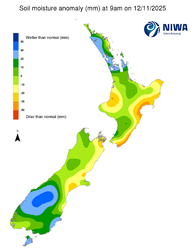
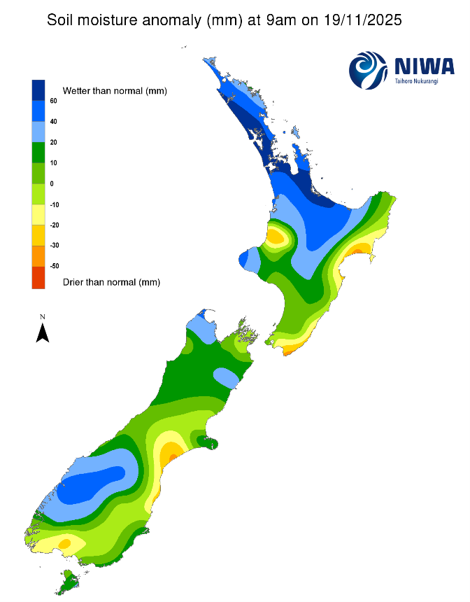
Pictured above: Soil Moisture Anomaly Maps, relative to this time of year. The maps show soil moisture anomalies over the past two weeks.
New Zealand Drought Index (NZDI)
As of 17 November, the New Zealand Drought Index (NZDI) map shows that abnormally dry conditions are currently found in eastern Marlborough, isolated areas in coastal North Canterbury, and very dry to extremely dry conditions are also located in southern Hawke’s Bay.
Please note: some hotspots in the text above may not correspond with the NZDI map. This difference exists because the NZDI uses additional dryness indices, including one which integrates the rainfall deficit over the past 60 days. Changes are therefore slower to appear in the NZDI compared to soil moisture anomaly maps that are instantaneously updated.
The week ahead:
In the North Island, high pressure is expected Friday and Saturday, 21-22 November. Despite high pressure, light rain showers and drizzle is possible over the North Island through the period and will continue into next week due to moist easterly flow. North-westerly flow moves over the North Island from Wednesday (26th November) onward. Weekly rainfall totals will likely be 25 mm or less for most of the North Island, with the exception of Gisborne, Bay of Plenty, Coromandel, and Northland ranges and foothills where 25 to 40 mm is possible, with isolated locations close to 50 mm.
Due to the expected rainfall in the next week, small decreases in soil moisture may occur in most of the North Island, with the exception of the foothills of the Bay of Plenty, Gisborne, and Hawke’s Bay ranges where soil moisture will likely stay the same. The current hotspots in Hawke’s Bay will not change substantially, while the dryness in the Wairarapa may move closer to, or even achieve, hotspot status.
In the South Island, a slow moving front will bring more rain to the west of the South Island 21-22 November. Another weak front will bring light rain to the south and east of the South Island 23-24 November, followed by dry weather on the 25th. On 26 November, low pressure moves in from the northwest out of the Tasman Sea, with moderate to heavy rain for the west of the South Island, followed by another front and more heavy rain next Thursday (the 27th). Weekly rainfall totals of 100 to 150 mm will be possible for the central and lower West Coast, with isolated spots seeing up to 200 mm, and 50 to 100 mm for the upper West Coast and far western Southland. Otago, Canterbury, and Marlborough will receive 25 mm or less in the week ahead, with the remainder of the South Island likely receiving 25 to 50 mm of rain.
Due to the expected rainfall in the next week, soil moisture levels will likely increase slightly in the western South Island while soil moisture is likely to decrease elsewhere in the South Island. The current hotspot in Canterbury and North Otago may strengthen and expand.
Long-term outlook (through late-December):
- The drier (25th percentile) rainfall scenario shows widespread below normal rainfall, especially in the South Island and lower North Island.
- In the middle (50th percentile) and wetter (75th percentile) scenarios, the pattern looks very La Niña-like, with above normal rainfall in northern and eastern regions, and less rainfall in the south and west.
- Very dry soil conditions may affect the east of both islands, a pattern that we’re already seeing emerge.
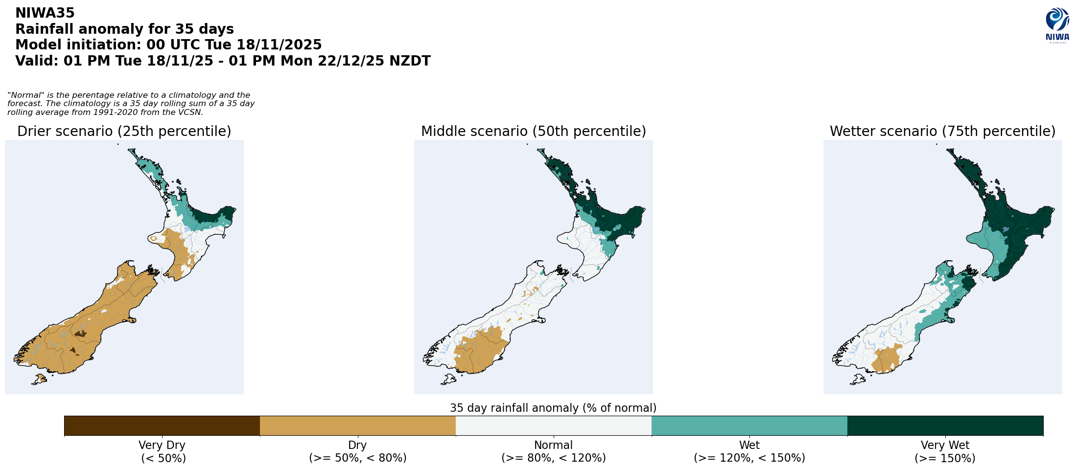
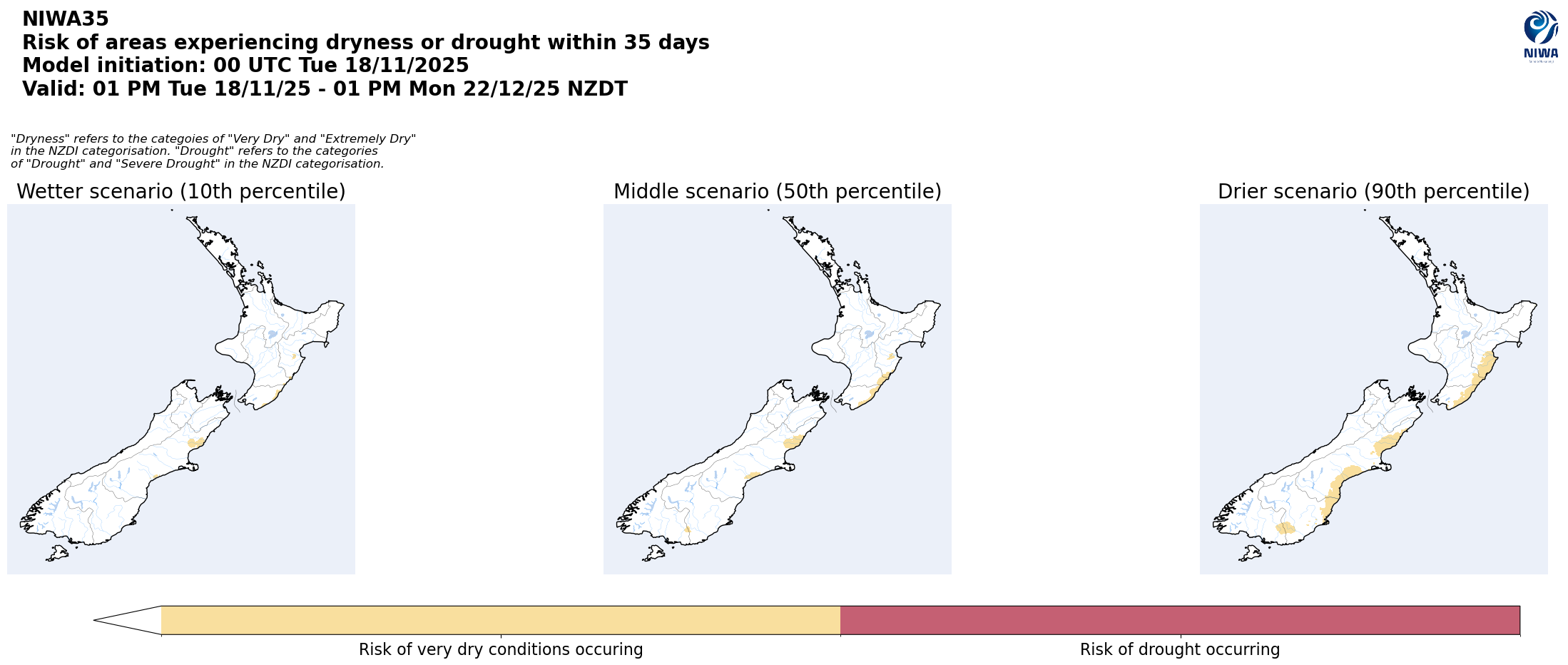
Pictured above: 35-day forecast rainfall anomaly scenarios (Top), and 35-day forecast dryness and drought scenarios (Bottom). These maps are updated daily at https://niwa.co.nz/climate/seasonal-climate-outlook
Background:
Hotspot Watch: a weekly advisory service for New Zealand media. It provides soil moisture and precipitation measurements around the country to help assess whether extremely dry conditions are imminent.
Soil moisture deficit: the amount of water needed to bring the soil moisture content back to field capacity, which is the maximum amount of water the soil can hold.
Soil moisture anomaly: the difference between the historical normal soil moisture deficit (or surplus) for a given time of year and actual soil moisture deficits.
Definitions: “Extremely” and “severely” dry soils are based on a combination of the current soil moisture status and the difference from normal soil moisture (see soil moisture maps at https://www.niwa.co.nz/climate/nz-drought-monitor/droughtindicatormaps)
Hotspot: A hotspot is declared if soils are "severely drier than normal" which occurs when Soil Moisture Deficit (SMD) is less than -110 mm AND the Soil Moisture Anomaly is less than -20 mm.