A weekly update describing soil moisture patterns across the country to show where dry to extremely dry conditions are occurring or imminent. Regions experiencing significant soil moisture deficits are deemed “hotspots”. Persistent hotspot regions have the potential to develop into drought.
Recent rainfall and current soil moisture conditions:
In the North Island, rainfall amounts of 30-60 mm generally fell across Northland, Auckland, northern Waikato, and Bay of Plenty in the past week, with localised amounts of 100 mm or more in Bay of Plenty and the Coromandel Peninsula. Conversely, the eastern and lower North Island, along with parts of Auckland and western Waikato, saw much lower totals of less than 25 mm. While soil moisture levels generally increased in Northland, Auckland, and the Coromandel Peninsula, the rest of the North Island generally saw moderate soil moisture decreases in the past week. The driest soils across the North Island, when compared to normal for this time of the year, are found in coastal Hawke’s Bay and Wairarapa, while the wettest soils for this time of the year are found in Northland, Auckland, and the Coromandel Peninsula.
The hotspot previously located in coastal Hawke’s Bay has strengthened and expanded in the past week, and a new hotspot has formed in coastal Gisborne. In addition, coastal Wairarapa may be approaching hotspot status. As of 10 November, the New Zealand Drought Index (NZDI) map shows that abnormally dry and very dry conditions are currently found in southern portions of Hawke’s Bay.
In the South Island, much of the West Coast and Fiordland received 75-150 mm of rain in the past week, with larger amounts in high terrain. The upper West Coast and Tasman generally saw 25-50 mm. However, the rest of the South Island saw only meagre rainfall; generally less than 15 mm. While little change in soil moisture levels was observed in the West Coast and Fiordland, the rest of the South Island generally saw small to moderate soil moisture decreases. The driest soils in the South Island, when compared to normal for this time of the year, are located in parts of Marlborough and central Canterbury, while the wettest soils for this time of the year are found in interior Otago.
Small hotspots have now formed in northeastern Marlborough and a small portion of central Canterbury just to the north of Christchurch. As of 10 November, the New Zealand Drought Index (NZDI) map shows that abnormally dry conditions are currently found in eastern Marlborough and isolated areas in coastal North Canterbury.
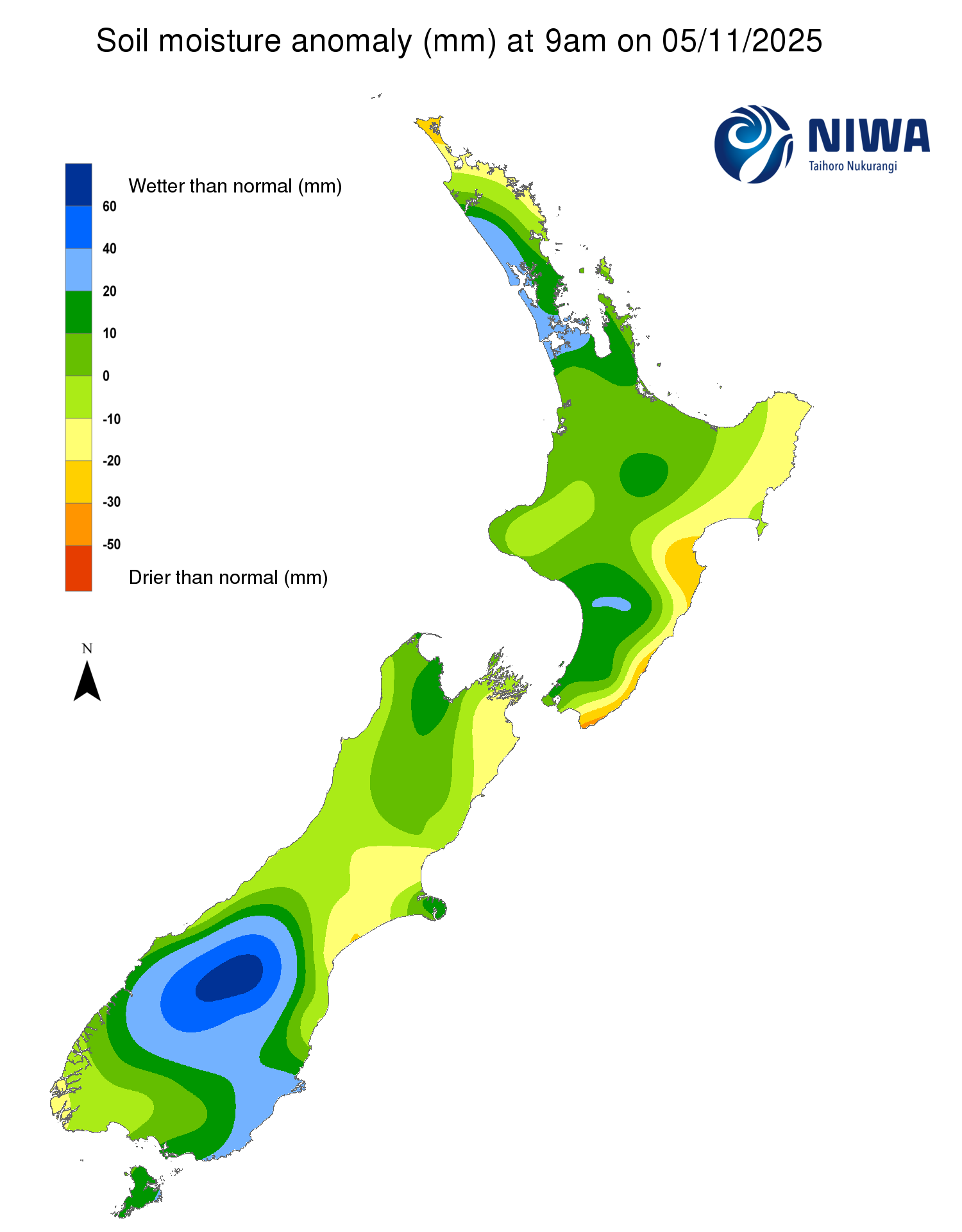
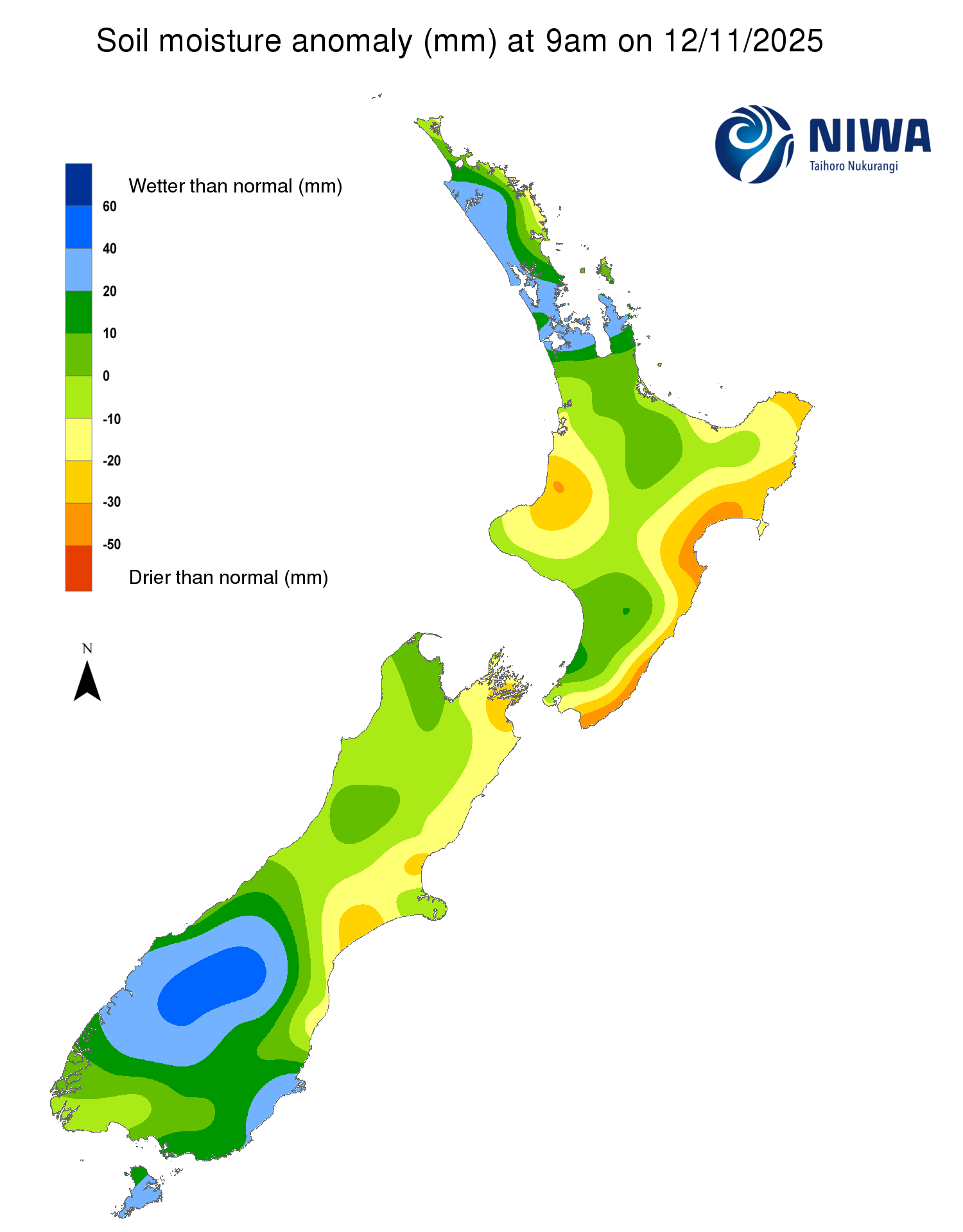
Pictured above: Soil Moisture Anomaly Maps, relative to this time of year. The maps show soil moisture anomalies over the past two weeks.
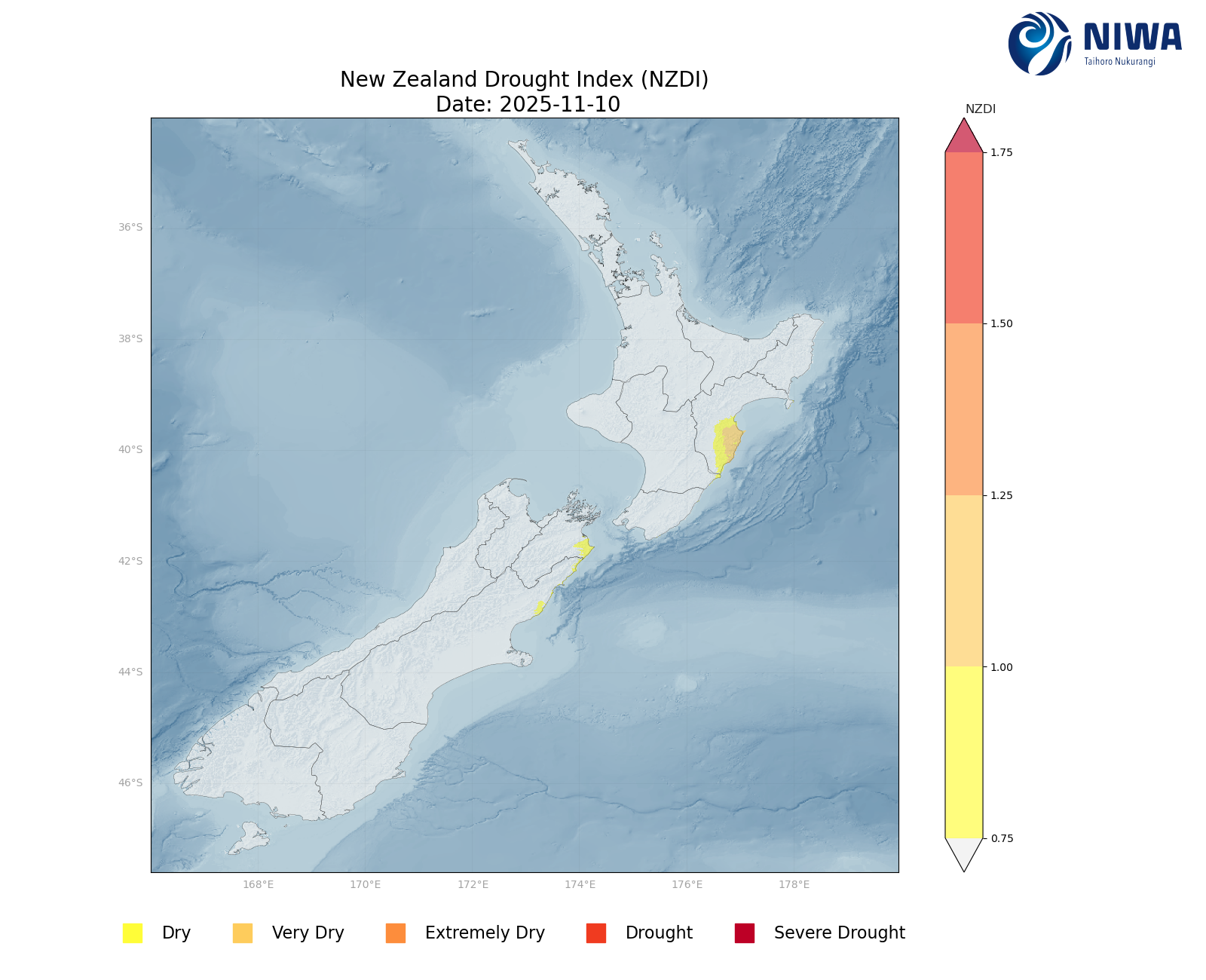
New Zealand Drought Index (NZDI)
As of 10 November, the New Zealand Drought Index (NZDI) map shows that abnormally dry conditions are currently found in southern portions of Hawke’s Bay, eastern Marlborough, and isolated areas in coastal North Canterbury. Very dry conditions are also located in southern Hawke’s Bay.
Please note: some hotspots in the text above may not correspond with the NZDI map. This difference exists because the NZDI uses additional dryness indices, including one which integrates the rainfall deficit over the past 60 days. Changes are therefore slower to appear in the NZDI compared to soil moisture anomaly maps that are instantaneously updated.
The week ahead:
In the North Island, periodic scattered showers will occur through Saturday (15 November). Thereafter, an area of high pressure near the country will provide mostly dry weather through much of Tuesday (18 November). After a period with better rainfall chances in the middle of next week, drier conditions may return. Weekly rainfall totals could reach 50-100 mm in places such as Bay of Plenty, with generally 30-50 mm in the rest of the upper North Island. However, the east coast and lower North Island may receive lower amounts of 25 mm or less.
Due to the expected rainfall in the next week, only small changes to soil moisture levels are likely in the upper North Island. However, small decreases may occur in the eastern and lower North Island. The current hotspots in Hawke’s Bay and Gisborne may not change substantially, while Wairarapa may move closer to, or even achieve, hotspot status.
In the South Island, a front will bring moderate rain to the West Coast on Friday (14 November), followed by a drier period through early next week due to high pressure. However, heavy rainfall is expected to impact the West Coast from Monday through early Wednesday (17-19 November), although the eastern South Island will miss out on most of this rainfall. Weekly rainfall totals of 150-300 mm will be possible for the central and lower West Coast, with somewhat lower totals farther north. While 30-50 mm may occur in Marlborough and northern Canterbury, South Canterbury and Otago may only receive less than 20 mm.
Due to the expected rainfall in the next week, soil moisture levels will likely increase in the western South Island. While little change is anticipated for Marlborough and northern Canterbury, areas farther south will likely see additional soil moisture decreases. The current hotspots in Marlborough and North Canterbury may not change significantly in the next week.
Long-term outlook (through mid-December):
- The drier (25th percentile) rainfall scenario shows widespread below normal rainfall, especially in the South Island and lower North Island.
- In the middle (50th percentile) and wetter (75th percentile) scenario, the pattern looks very La Niña-like, with above normal rainfall in northern and eastern regions, and less rainfall in the south and west.
- Very dry soil conditions may affect the east of both islands, a pattern that we’re already seeing emerge.
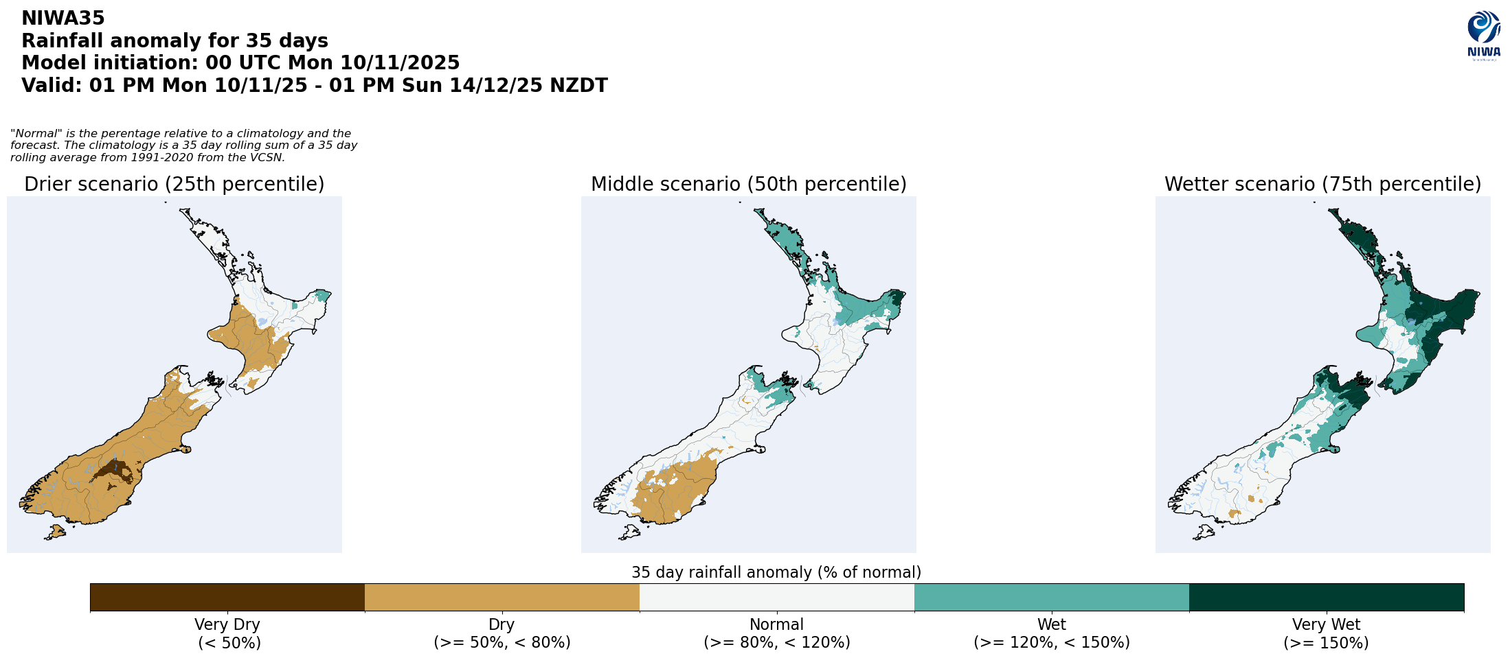
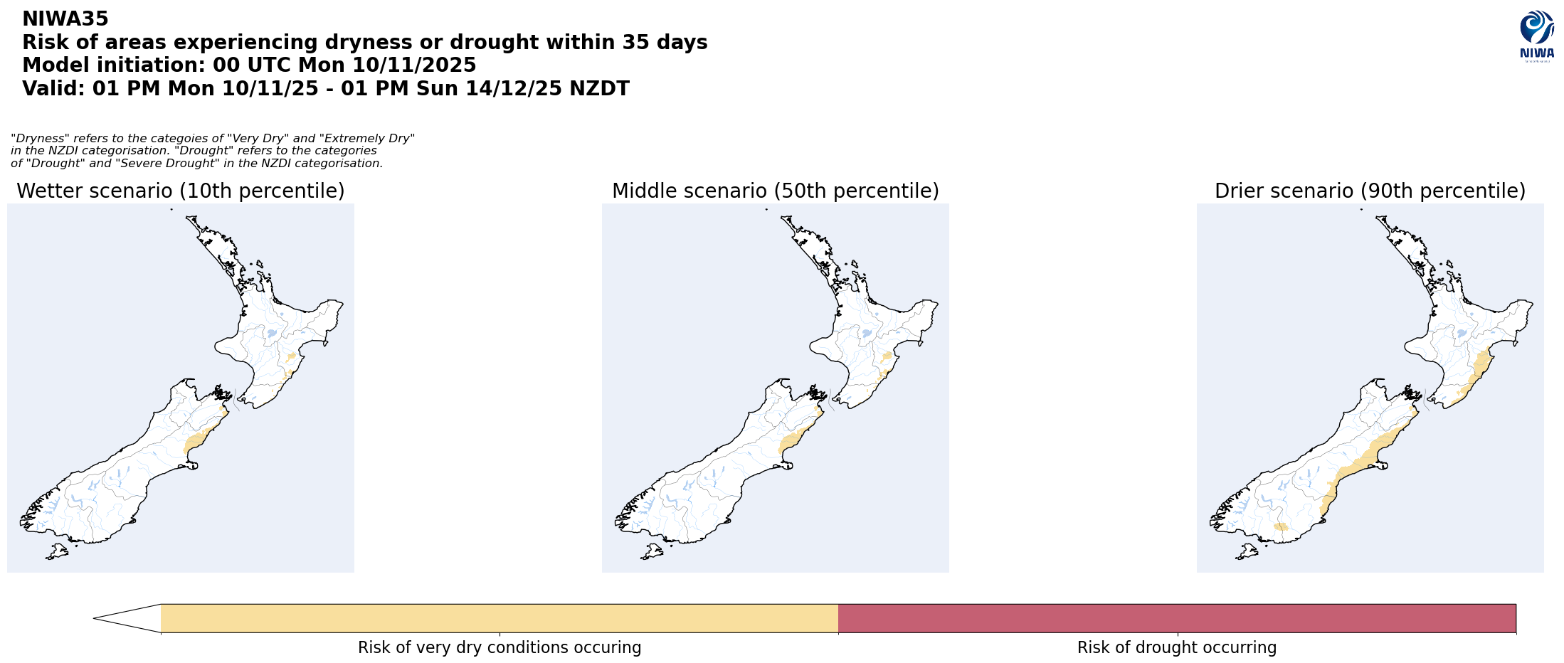
Pictured above: 35-day forecast rainfall anomaly scenarios (Top), and 35-day forecast dryness and drought scenarios (Bottom). These maps are updated daily at https://niwa.co.nz/climate/seasonal-climate-outlook
Background:
Hotspot Watch: a weekly advisory service for New Zealand media. It provides soil moisture and precipitation measurements around the country to help assess whether extremely dry conditions are imminent.
Soil moisture deficit: the amount of water needed to bring the soil moisture content back to field capacity, which is the maximum amount of water the soil can hold.
Soil moisture anomaly: the difference between the historical normal soil moisture deficit (or surplus) for a given time of year and actual soil moisture deficits.
Definitions: “Extremely” and “severely” dry soils are based on a combination of the current soil moisture status and the difference from normal soil moisture (see soil moisture maps)
Hotspot: A hotspot is declared if soils are "severely drier than normal" which occurs when Soil Moisture Deficit (SMD) is less than -110 mm AND the Soil Moisture Anomaly is less than -20 mm.