| Temperature | September overall has been a warm month for Aotearoa New Zealand. Temperatures were above average (0.51-1.20°C above average) or well above average (>1.20°C above average) in Canterbury, Marlborough, Tasman, Wellington, the Manawatū, most of Hawke’s Bay, Gisborne, Taranaki, and much of the Waikato, Auckland, and Northland. Fiordland experienced temperatures below average (0.51-1.20°C below average). The remaining parts of the country were near average for temperatures (±0.50°C of average). |
| Rainfall | Rainfall was below normal (50-79% of normal) or well below normal (<50% of normal) for the east coast of both islands, mainly centred on Hawke’s Bay, Wairarapa, Nelson, Marlborough, Canterbury, and coastal Otago. Rainfall was well above normal (>149% of normal) or above normal (120-149% of normal) for the West Coast, Southland, inland Otago, Taranaki, Waikato, and the Bay of Plenty. Elsewhere, near normal rainfall (80-119% of normal) fell in September. |
| Soil Moisture | At the end September, soil moisture levels were lower than normal for central parts of Hawke’s Bay, and isolated parts of Marlborough and northern Otago. Soil moisture was higher than normal for inland and central parts of Otago. Elsewhere, near normal soil moisture levels were typical for the remainder of the country. |
Overview
Mean sea level air pressure was higher than normal across the top of the North Island and in the Pacific Ocean north of Aotearoa New Zealand, while low pressure was strong and persistent across the South Island. The resulting pressure gradient (difference of air pressure between low and high pressure) led to strong westerlies across the country. The westerlies were most pronounced across the South Island in September. The result was a wet and unsettled month in the west of the South Island, with multiple gale wind events in the east of the South Island. ENSO-neutral (El Niño – Southern Oscillation) conditions remained present in the tropical Pacific, but like August, La Niña-like patterns became more established during the month. Sea surface temperatures (SSTs) around New Zealand were mostly above average, particularly off the west coast of the country with Marine Heatwave (MHW) conditions experienced in these areas. [Marine heatwave conditions are defined as five or more consecutive days with SSTs above the 90th percentile for the time of year.] In contrast with August, SSTs were cooler near the southeast of the country, and SSTs were below average for many areas east of both the North Island and upper South Island.
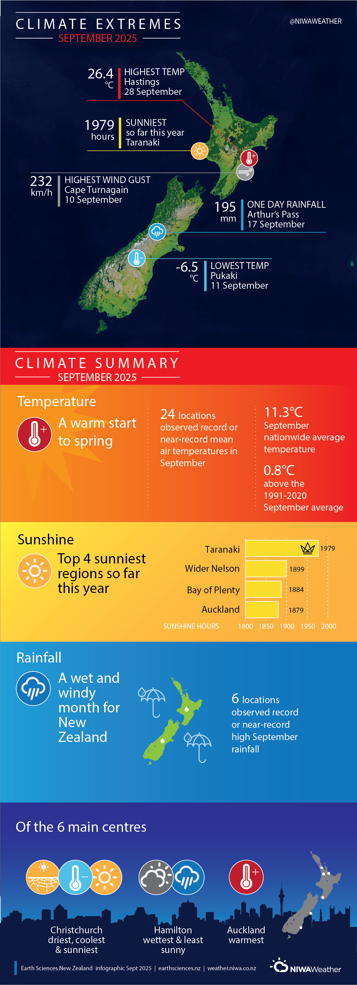
The nationwide average temperature in September 2025 was 11.3°C. This is 0.8°C above the 1991-2020 September average, making it New Zealand’s 6th-warmest September on record. The month was relatively warm across the entirety of the North Island. Northland and a portion of Hawke’s Bay experienced the warmest weather, with temperatures well above average (>1.20°C above average). Temperatures for remaining portions of the North Island were above average (0.51-1.20°C above average) except in the Central North Island, where temperatures in parts of Waikato, Manawatū, interior Hawke’s Bay and inland Bay of Plenty were mostly near average (±0.50°C of average). Across the South Island, much of Canterbury and Blenheim experienced well above average temperatures in September (>1.20°C above average), while remaining parts of Marlborough, Tasman, and portions of Otago saw temperatures above average (0.51-1.20°C above average). Fiordland experienced below average temperatures (0.51-1.20°C below average). The remaining areas of the South Island had temperatures that were mostly near average (±0.50°C of average).
September was a wet month for the west and south of the South Island and the west and the north of the North Island, with drier than normal conditions for the east of the North Island and the east and the top of the South Island. Rainfall was below normal (50-79% of normal) or well below normal (<50% of normal) centred on Hawke’s Bay, Gisborne, Wairarapa, Cape Reinga, parts of Tasman, Nelson, Marlborough, Canterbury, and coastal Otago. Rainfall was well above normal (>149% of normal) or above normal (120-149% of normal) for the West Coast, Southland, inland Otago, and portions of Taranaki, northern parts of the Waikato, southern Auckland, around the Bay of Islands in Northland, and a small portion of the western Bay of Plenty. Elsewhere, near normal rainfall (80-119% of normal) fell in September.
Further highlights
- The highest temperature was 26.4°C, observed at Hastings on 28 September.
- The lowest temperature was -6.5°C, observed at Pukaki on 11 September.
- The highest 1-day rainfall was 195 mm, recorded at Arthur’s Pass 17 September.
- The highest wind gust was 232 km/h, observed at Cape Turnagain on 10 September.
- Of the six main centres in September 2025, Auckland (Māngere) was the warmest, Christchurch was the driest, coolest and sunniest, Hamilton was the wettest and least sunny.
- The sunniest four regions in 2025 so far are Taranaki (1979 hours), wider Nelson (1899 hours), Bay of Plenty (1884 hours), and Auckland (1879 hours).
Download
September 2025 Climate Summary [PDF 3MB]
