Warmer and drier than normal for many
|
Rainfall |
Well below normal rainfall (<50% of normal) was widespread in the eastern North Island and in parts of the central North Island and eastern South Island. Near normal rainfall (80-119% of normal) occurred in Northland, parts of Auckland, western Waikato, west coastal Taranaki, east coastal Bay of Plenty, northern Tasman, Nelson, the West Coast, Fiordland, coastal Southland, and near Oamaru. Small patches of above normal rainfall (120-149% of normal) were found in southern Northland and lower Westland. Below normal rainfall (50-79%) occurred elsewhere. |
|
Temperature |
Above average temperatures (0.50-1.20˚C above average) were common across the country. Temperatures were well above average (>1.20˚C above average) in parts of eastern Waikato, Coromandel, Bay of Plenty, Gisborne, Hawke’s Bay, Manawatū-Whanganui, south coastal Wairarapa, northern Tasman, northern Marlborough, Canterbury, and Otago. Patches of near average temperatures (±0.50°C of average) were found in Northland, western Waikato, the northern West Coast, and southern Tasman and Marlborough. |
|
Soil Moisture |
At the beginning of May, soil moisture levels were in severe deficit across the eastern North Island and eastern and interior South Island, particularly across Gisborne, Hawke’s Bay, Canterbury, Otago, and Southland. Pockets of below normal soil moisture were also present about the Coromandel Peninsula and Auckland. Elsewhere, soil moisture levels were largely near or slightly above normal. |
Overview
April featured lower than normal air pressure around Aotearoa New Zealand, in the Tasman Sea, and Southern Ocean. For New Zealand, this was associated with more westerly winds than normal, which steered several unusually warm air masses toward the country during the first half of the month.
Over three dozen locations observed near record or record high maximum temperatures, a majority of which occurred between 4-6 April. Particularly impressive was a maximum temperature of 30.8˚C in Timaru on 4 April, New Zealand’s 4th-highest April temperature on record.
The atypical warmth also caused coastal sea temperature anomalies to spike, ranging from 0.5 to 1.3˚C above average around the country for the month.
La Niña, which began in October 2020, transitioned to ENSO neutral during April with equatorial ocean temperatures and the Southern Oscillation Index within the neutral range. A pulse of the Madden-Julian Oscillation, an eastward-moving area of rain and cloud in the global tropics, was active over the Pacific during April and was associated with a westerly air flow anomaly for New Zealand.
These westerly winds dried out as they descended the interior mountain ranges and flowed into the east of both islands, with below normal rainfall again a theme. Just 13 mm of rain fell in Dunedin (Musselburgh), the city’s equal-driest April on record since records began in 1918.
Further Highlights:
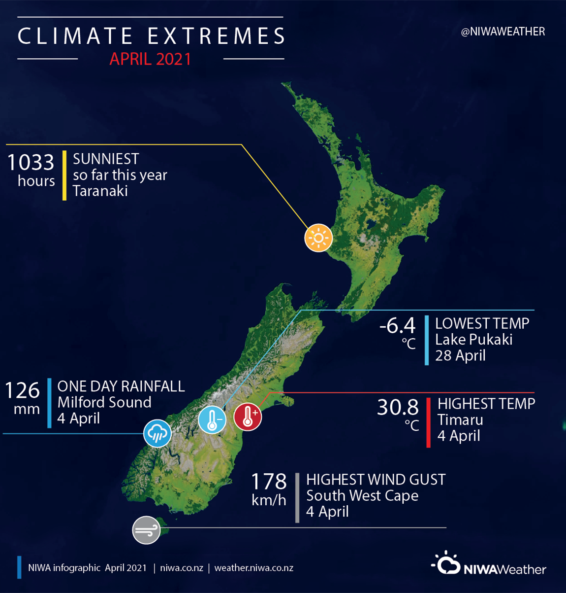
- The highest temperature was 30.8°C, observed at Timaru on 4 April.
- The lowest temperature was -6.4°C, observed at Lake Pukaki on 28 April.
- The highest 1-day rainfall was 126 mm, recorded at Milford Sound on 4 April.
- The highest wind gust was 178 km/h, observed at South West Cape on 4 April.
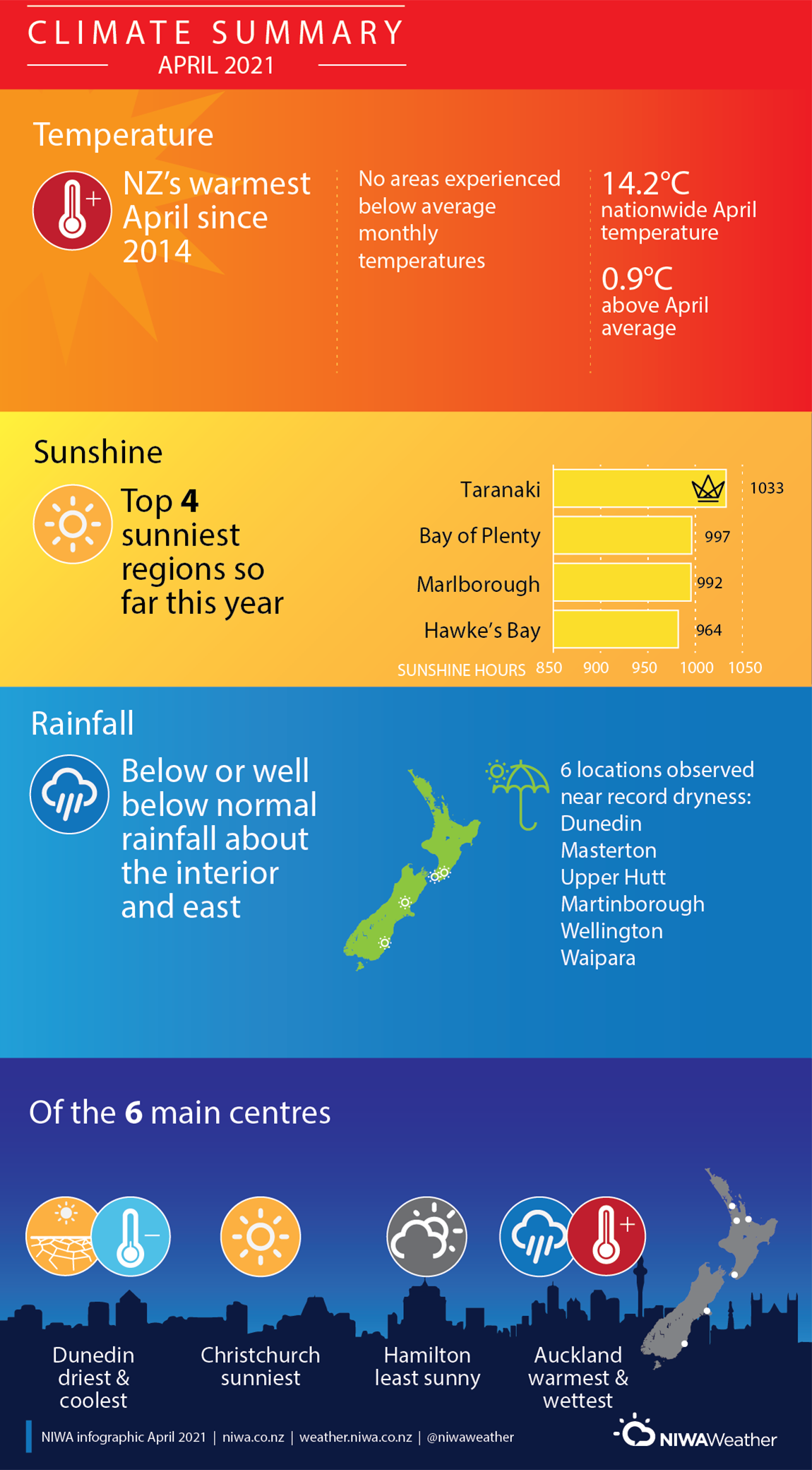
- Of the six main centres in April 2021, Auckland was the warmest and wettest, Christchurch was the sunniest, Dunedin was the coolest and driest, and Hamilton was the least sunny.
- Of the available, regularly reporting sunshine observation sites, the sunniest four locations so far in 2021 are Taranaki (1033 hours), Bay of Plenty (997 hours), Marlborough (992 hours), Horowhenua (964 hours) and Hawke’s Bay (964 hours).
- The mean temperature for April 2021 was 14.2°C which is 0.9°C warmer than normal (1981-2010).