Wet and warm for much of New Zealand
|
Rainfall |
Over double the normal November rainfall total (>200% of normal) was recorded for parts of Waikato, Bay of Plenty, central North Island, Hawke’s Bay, Taranaki, Wellington, Nelson and Tasman. Other areas that experienced above (120-149% of normal) or well above normal rainfall (>149% of normal) were the remainder of the North Island except for the Far North, East Cape, and western Waikato. Most of Marlborough, Canterbury and Buller also experienced above or well above normal rainfall. Well below normal rainfall (<50% of normal) was experienced in much of Southland, Fiordland, and the southern half of the West Coast. Rainfall was near normal (80-119% of normal) or below normal (50-79% of normal) for the remainder of the country (the Far North, western Waikato, Otago, and the central West Coast). |
|
Soil Moisture |
As at 30 November, soil moisture levels were higher than normal for most of the North Island south of Hamilton, as well as Nelson-Tasman. Soil moisture levels were lower than normal for much of Northland to northern Waikato and the southern half of the South Island. |
|
Temperature |
Temperatures were well above average (>1.20°C above average) for areas of eastern Northland, Auckland, Coromandel, Bay of Plenty, Taranaki, Gisborne, and the West Coast. For most other parts of New Zealand, temperatures were above average (0.51-1.20°C above average), except for Wellington, Marlborough and parts of Canterbury which had near average (±0.50°C of average) temperatures. |
Overview
November 2020 was a wet and warm month for much of New Zealand, with the rainfall and temperature patterns strongly influenced by La Niña. Mean sea level pressure was slightly higher than normal to the west and south of New Zealand, resulting in weak air flow anomalies. Some very heavy rainfall events and flooding occurred in the North Island (particularly in Napier, New Plymouth, Te Awamutu, and Porirua) throughout the month, associated with humid and moist air masses. Impacts of these rainfall events are covered in the Highlights and extreme events section. In contrast, the southwestern part of the South Island was relatively sheltered from these air masses, which resulted in a dry November. The tropically-derived air masses, in addition to warmer than average coastal sea surface temperatures, were also responsible for the higher than average temperatures experienced across most of the country during November.
Further Highlights:
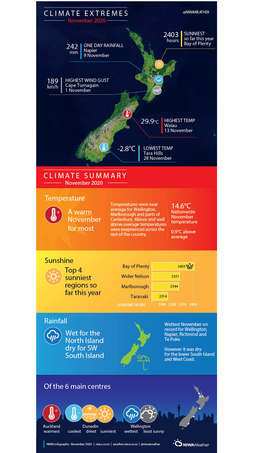
- The highest temperature was 29.9°C, observed at Waiau on 13 November.
- The lowest temperature was -2.8°C, observed at Tara Hills on 28 November.
- The highest 1-day rainfall was 242 mm, recorded at Napier on 9 November.
- The highest wind gust was 189 km/h, observed at Cape Turnagain on 1 November.
- Of the six main centres in November 2020, Auckland was the warmest, Dunedin was the coolest, driest, and sunniest, and Wellington was the wettest and least sunny.
- Of the available, regularly reporting sunshine observation sites, the sunniest four locations in 2020 so far are Bay of Plenty (2403 hours), Greater Nelson (2351 hours), Marlborough (2344 hours), and Taranaki (2314 hours).