Severe flooding in Canterbury to end the month
|
Rainfall |
An exceptionally heavy rainfall event spanning the final three days of the month caused severe flooding in Canterbury. For the month overall, rainfall was well above normal (>149% of normal) for much of Canterbury, Tasman, and western parts of Taranaki, with considerable portions of Canterbury observing at least 200% of normal rainfall for May. Rainfall was above normal (120-149% of normal) for southern and central Otago, central and northern Southland, Nelson, Marlborough, and the Kapiti Coast. Rainfall was below normal (50-79% of normal) for coastal parts of the South Island from Invercargill to Oamaru, the southern West Coast, and the majority of the North Island. Rainfall was well below normal (<50% of normal) in parts of Auckland, Waikato and Wairarapa. |
|
Soil Moisture |
At the end of May, soils were wetter than normal for the eastern South Island north of Otago. In contrast, soils were considerably drier than normal for eastern parts of the North Island from Wairarapa to Hawke’s Bay, much of Auckland, and northern Northland. Drier than normal soils were prominent in parts of Waikato, coastal Manawatū-Whanganui, the lower West Coast, much of Otago, and eastern Southland. |
|
Temperature |
Temperatures were above average (0.51-1.20°C above average) or well above average (>1.20°C above average) for many parts of the country. The main exceptions were parts of Northland, western Waikato, the Central Plateau, Marlborough, coastal Canterbury south of Banks Peninsula, and southern and central parts of Otago and Southland, where temperatures were near average (±0.50°C of average). |
Overview
May 2021 mean sea level air pressure was above normal over and to the east of Aotearoa New Zealand. Overall, this resulted in a relatively settled and dry month throughout the country, with periods of relatively high daily maximum temperatures and low minimum temperatures for inland and eastern parts of the country. However, towards the end of the month, areas of deep low pressure became established over and east of the country. Initially, a persistent deep low pressure system centred east of Northland drove several days of large swells into the eastern North Island, causing erosion of coastal land in some parts. A subsequent low pressure system became established in the Tasman Sea near Taranaki, and travelled southeast to become centred near Wellington. This system caused several days of predominantly southeasterly winds over the South Island. In addition, the system linked with an atmospheric river to deliver enhanced levels of water vapour from the tropics to New Zealand. These factors culminated in a significant rainfall event over several days in Canterbury, causing widespread and severe flooding for eastern areas of the region including the eastern foothills, the Canterbury Plains and Banks Peninsula. Further details of this rainfall event are listed in the Highlights and extreme events section.
Overall, May rainfall was well above normal (>149% of normal) for much of Canterbury, Tasman, and western parts of Taranaki. Considerable portions of Canterbury observed at least 200% of normal rainfall for May, with several locations on the Canterbury Plains receiving more than 300% of normal rainfall. May was also a relatively wet month for southern and central Otago, central and northern Southland, Nelson, Marlborough, and the Kapiti Coast where rainfall was above normal (120-149% of normal). In contrast, it was a relatively dry May for much of the North Island and isolated parts of the South Island. Rainfall was below normal (50-79% of normal) for coastal parts of the South Island from Invercargill to Oamaru, the southern West Coast, and parts of every North Island region. Rainfall was well below normal (<50% of normal) in parts of Auckland, Waikato and Wairarapa.
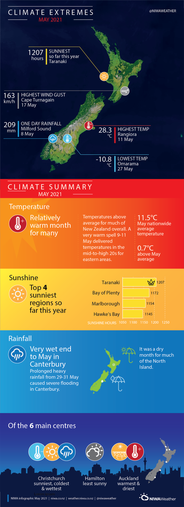
Temperatures were above average (0.51-1.20°C above average) in parts of every New Zealand region. It was a particularly warm month for areas of Waikato, Bay of Plenty, Gisborne, Hawke’s Bay, Manawatū-Whanganui, Tasman, the West Coast, and isolated parts of eastern and inland Canterbury where temperatures were well above average (>1.20°C above average). Temperatures were near average (±0.50°C of average) for parts of Northland, western Waikato, the Central Plateau, Marlborough, coastal Canterbury south of Banks Peninsula, and southern and central parts of Otago and Southland. Overall, the nationwide average temperature in May 2021 was 11.5°C. This is 0.7°C above the 1981-2010 May average from NIWA’s seven station temperature series which begins in 1909.
Further Highlights:
- The highest temperature was 28.3°C, observed at Rangiora on 11 May. This was New Zealand’s third-highest temperature for May on record.
- The lowest temperature was -10.8°C, observed at Tara Hills (Omarama) on 27 May. This was New Zealand’s lowest May temperature since 2001.
- The highest 1-day rainfall was 209 mm, recorded at Milford Sound on 8 May.
- The highest wind gust was 163 km/h, observed at Cape Turnagain on 17 May.
- Of the six main centres in May 2021, Auckland was the warmest and driest, Christchurch was the coldest, wettest, and sunniest, and Hamilton was the least sunny.
- Of the available, regularly reporting sunshine observation sites, the sunniest four locations in 2021 so far are Taranaki (1207 hours), Bay of Plenty (1172 hours), Marlborough (1154 hours) and Hawke’s Bay (1145 hours).
Download
- Climate Summary May 2021 (PDF 395.76 KB)
- Climate Statistics - May 2021 (PDF 156.54 KB)


