A dry month with mixed temperatures
|
Rainfall |
Below normal rainfall (50-79% of normal) or well below normal rainfall (<50% of normal) was observed in much of the country. Parts of the Far North and Whangārei Districts observed above normal rainfall (120-149% of normal). Near normal rainfall (80-119%) was observed in most of Auckland, the Coromandel, some areas around Gisborne and Hawke’s Bay, as well as Stewart Island. |
|
Temperature |
Temperatures were above average (0.51-1.20°C above average) or well above average (>1.20°C above average) in parts of Waikato, inland areas of Marlborough, southern Tasman, northern and southwestern portions of Canterbury, northern and southern portions of the West Coast, inland Otago, and western and central Southland. However, below average temperatures (0.51-1.20°C below average) were observed in western Taranaki, Kapiti Coast, the southwest fringe of Manawatū-Whanganui, and a small area of Nelson. The rest of New Zealand experienced near average temperatures (±0.50°C of average). |
|
Soil Moisture |
At the end of February, soil moisture levels were lower than normal for nearly all of the North Island for this time of year, except the Far North, where soil moisture was normal or above normal. In the South Island, soil moisture levels were near normal in small portions of the central West Coast and southern Canterbury. The remainder of the South Island had below normal soil moisture levels. |
Overview
February mean sea level pressure was higher than normal over and to the southeast of New Zealand. This resulted in more easterly quarter air flows for the North Island and little or no flow anomaly in the South Island. The pattern was associated with the continuation of a non-traditional central Pacific La Niña, which weakened slightly for the second consecutive month.
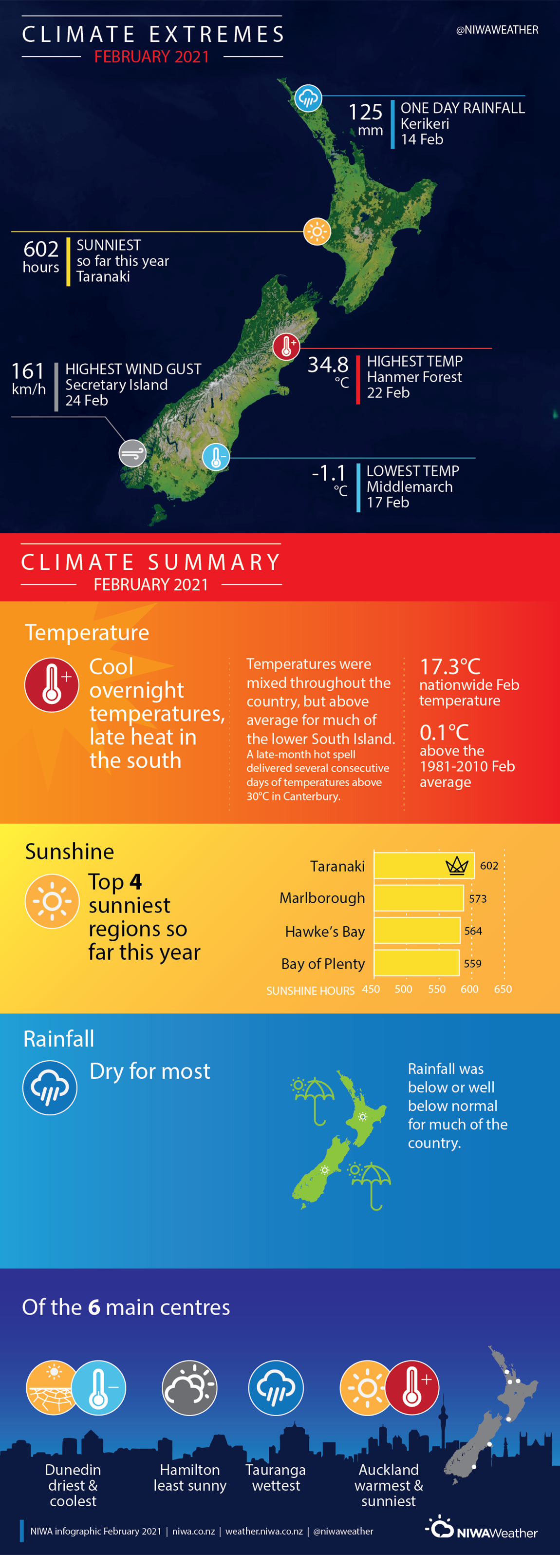
Most of Aotearoa New Zealand experienced below normal rainfall (50-79% of normal) or well below normal rainfall (<50% of normal) during February. However, during the middle of the month, an area of low pressure caused heavy rain across parts of Northland, Auckland, Bay of Plenty and Gisborne. Daily rainfall totals exceeded 100 mm in a number of locations, and places like Kerikeri, Te Puke and Kaikohe recorded their heaviest rain since last winter. This brief spell of wet weather meant that some areas received their monthly rainfall or more in a short period of time.
February temperatures were above average (0.51-1.20°C above average) or well above average (>1.20°C above average) in parts of Waikato, inland areas of Marlborough, southern Tasman, northern and southwestern portions of Canterbury, northern and southern portions of the West Coast, inland Otago, and western and central Southland. The only areas to experience below average temperatures (0.51-1.20°C below average) were western Taranaki, Kapiti Coast, the southwest fringe of Manawatū-Whanganui, and a small area of Nelson. The nationwide average temperature in February 2021 was 17.3°C. This was 0.1°C above the 1981-2010 February average from NIWA’s seven station temperature series which begins in 1909.
Further Highlights:
- The highest temperature was 34.8°C, observed at Hanmer Forecast on 22 February. This was the hottest day in a six-day heatwave where maximum temperatures exceeded 30°C on each day.
- The lowest temperature was -1.1°C, observed at Middlemarch on 17 February.
- The highest 1-day rainfall was 125 mm, recorded at Kerikeri on 14 February.
- The highest wind gust was 161 km/h, observed at Secretary Island on 24 February.
- Of the six main centres in February 2021, Auckland was the warmest and sunniest, Dunedin was the driest and coolest, Tauranga was the wettest and Hamilton was the least sunny.
- Of the available, regularly reporting sunshine observation sites, the sunniest four locations so far in 2021 are Taranaki (602 hours), Marlborough (573 hours), Hawke’s Bay (564 hours) and Bay of Plenty (559 hours).