Dry in the North Island; flooding in the lower South Island
|
Rainfall |
February was extremely dry across the North Island with most locations observing well below normal (<50% of normal) rainfall. In fact, some locations in Northland and the central North Island received less than 10% of their normal February rainfall. Well below normal rainfall also occurred across Nelson and Marlborough. Rainfall was generally below normal (50-79% of normal) from Taranaki to Kapiti Coast as well as much of Tasman and northern Canterbury. Conversely, rainfall was above normal (120-149% of normal) or well above normal (>149% of normal) across much of the lower West Coast, Otago, and Southland. Some locations observed rainfall amounts >200% of their February normal. |
|
Temperature |
February was a warm month across New Zealand, with above average (0.51-1.20°C above average) to well above average (>1.20°C above average) temperatures observed across nearly all of the North Island as well as much of the upper and central South Island. Meanwhile, near average (-0.5°C to +0.5°C from average) temperatures were observed across western Waikato, coastal Taranaki, much of the West Coast, and Fiordland. |
|
Soil Moisture |
As of 1 March, soil moisture levels were below to well below normal across nearly all of the North Island and the top of the South Island. In addition, severe meteorological drought was in place across Northland, Auckland, much of Waikato, western Bay of Plenty, East Cape, and southern Marlborough, while meteorological drought was found from Gisborne to Bay of Plenty and south to Manawatu-Whanganui and eastern Taranaki. Conversely, soils were wetter than normal across the West Coast, Otago, and much of Southland. |
Overview
February 2020 was characterised by above normal pressure over and north of the North Island, with below normal pressure to the southeast of New Zealand. This pressure setup was associated with minimal air flow anomalies, particularly in the North Island where high pressure was dominant during February.
February was extremely dry across nearly all of the North Island and the top of the South Island, with widespread below or well below normal rainfall observed. Several locations experienced record or near-record long dry spells (see Highlights and extreme events for further details), while as of 29 February severe meteorological drought was present across Northland, Auckland, much of Waikato, western Bay of Plenty, East Cape, and southern Marlborough according to NIWA’s New Zealand Drought Index. This resulted in numerous water restrictions, fire bans, and MPI declaring two medium-scale adverse events from Northland to northern Waikato. Conversely, heavy rainfall in early February resulted in severe flooding across Fiordland, Otago, and Southland, particularly along the Mataura River. Several locations in the lower South Island observed record or near-record February rainfall amounts.
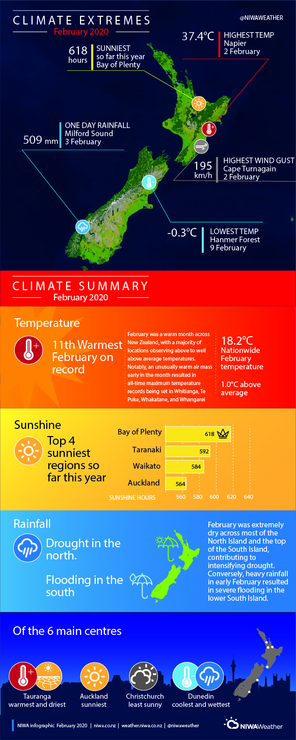
February was a warm month across New Zealand, with a majority of locations observing above or well above average temperatures due to prominent high pressure and prevalent sunshine. Notably, an unusually warm air mass early in the month resulted in all-time maximum temperature records being set in Whitianga, Te Puke, Whakatane, and Whangarei (see Highlights and extreme events for further details). The nationwide average temperature in February 2020 was 18.2°C, which is 1.0°C above the 1981-2010 February average from NIWA’s seven station temperature series which begins in 1909, and the 11th-warmest February on record.
New Zealand has not had a month with below average temperatures in 37 months, or since January 2017.
Further Highlights:
- The highest temperature was 37.4˚C, observed at Napier on 2 February.
- The lowest temperature was -0.3˚C, observed at Hanmer Forest on 9 February.
- The highest 1-day rainfall was 509 mm, recorded at Milford Sound on 3 February.
- The highest wind gust was 195 km/h, observed at Cape Turnagain on 2 February.
- Of the six main centres in February 2020, Tauranga was the warmest and driest, Dunedin was the coldest and wettest, Auckland was the sunniest, and Christchurch was the least sunny.
- Of the available, regularly reporting sunshine observation sites, the sunniest four locations in 2020 so far are Bay of Plenty (618 hours), Taranaki (592 hours), Waikato (584 hours) and Auckland (564 hours).
