A generally warm month with variable rainfall patterns
|
Temperature |
Temperatures were above average (0.51°C to 1.20°C above average) to well above average (>1.20°C above average) across a majority of the North Island, Nelson, Tasman, the West Coast, much of southern Canterbury, Otago, and Southland. Near average (±0.50°C of average) temperatures were observed in coastal Gisborne, Hawke’s Bay, eastern Marlborough, northern Canterbury, and pockets of interior Otago. |
|
Rainfall |
December rainfall was above normal (120-149% of normal) or well above normal (>149% of normal) in eastern Northland, the Coromandel Peninsula, Bay of Plenty, much of the Central Plateau, southern Gisborne, Hawke’s Bay, Wairarapa, eastern Marlborough, and parts of northern and southern Canterbury. Below normal (50-79% of normal) or well below normal (<50% of normal) rainfall was observed in the Far North, southern Auckland, Tasman, the West Coast, Banks Peninsula, along with most of Otago and Southland. Elsewhere, near normal (80-119% of normal) rainfall was observed. |
|
Soil Moisture |
At the end of December, soil moisture levels were above normal or well above normal in southern Northland, Auckland, the Coromandel Peninsula, Bay of Plenty, the Central Plateau, Hawke’s Bay, much of Manawatū-Whanganui and Wellington, along with parts of northern and central Canterbury. Soil moisture levels were below normal in a portion of the Far North, Māhia Peninsula, Nelson, the West Coast, Banks Peninsula, and coastal Otago and Southland. Elsewhere, soil moisture levels were generally near normal. |
Overview
December 2022 was characterised by higher than normal mean sea level pressure over and to the south of the South Island, with lower than normal pressure north of Aotearoa New Zealand. La Niña, a positive Southern Annular Mode (SAM), and a moderate-to-strong marine heatwave influenced New Zealand’s climate during December. The SAM is a proxy for the location of a belt of westerly winds that encircle the South Ocean and occasionally protrude into the mid-latitudes. Usually, a positive SAM indicates calmer and drier conditions for New Zealand.
The combination of these climate drivers produced substantially more easterly airflows than normal during December. This resulted in a temperature pattern where western areas tended to be warmer than eastern areas due to easterly Foehn winds. Similarly, eastern regions of New Zealand were generally wetter than western regions due to the enhanced onshore wind flow in the east.
The second half of December featured a nearly stationary area of low pressure located in the Tasman Sea that brought a humid, unstable air mass to New Zealand. This resulted in almost daily afternoon showers and thunderstorms across large portions of the country, some resulting in flooding. This included flash flooding in South Taranaki on 19 December, where several roads were closed, and Hamilton on 20 December, which recorded its third-wettest hour on record with 24.2 mm between 12:00-1:00 pm. On 17 December, a tornado moved through rural Alexandra and Springvale, causing extensive damage to some properties (see the highlights and extreme events section for more details).
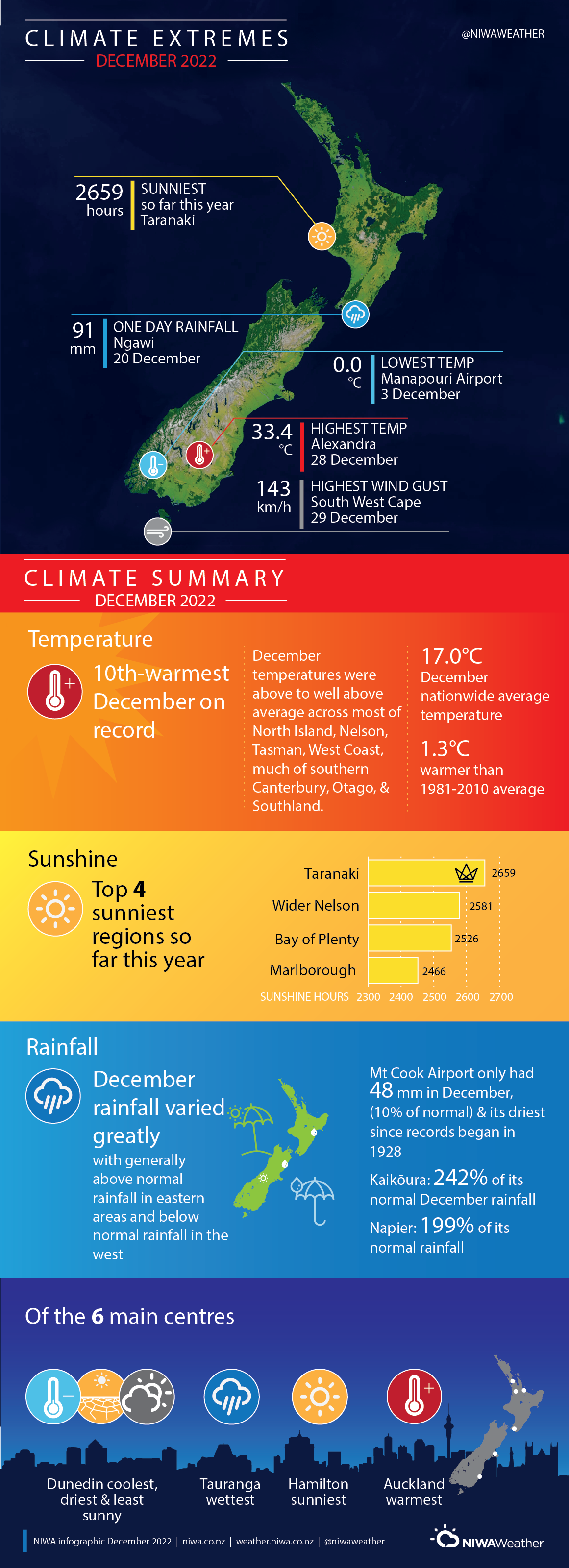
December temperatures were above average (0.51°C to 1.20°C above average) to well above average (>1.20°C above average) across a majority of the North Island, Nelson, Tasman, the West Coast, much of southern Canterbury, Otago, and Southland. Near average (±0.50°C of average) temperatures were observed in coastal Gisborne, Hawke’s Bay, eastern Marlborough, northern Canterbury, and pockets of interior Otago. Overall, the nationwide average temperature for December 2022 was 17.0°C (1.3°C above the 1981-2010 October average), making it the 10th-warmest December on record based on NIWA’s seven station temperature series that begins in 1909. Furthermore, coastal sea surface temperatures ranged from 1.1˚C to 1.8˚C above average during December as compared to the 1991-2020 December average, qualifying as a moderate-to-strong marine heatwave.
December rainfall was above normal (120-149% of normal) or well above normal (>149% of normal) in eastern Northland, the Coromandel Peninsula, Bay of Plenty, much of the Central Plateau, southern Gisborne, Hawke’s Bay, Wairarapa, eastern Marlborough, and parts of northern and southern Canterbury. Below normal (50-79% of normal) or well below normal (<50% of normal) rainfall was observed in the Far North, southern Auckland, Tasman, the West Coast, Banks Peninsula, along with most of Otago and Southland. Elsewhere, near normal (80-119% of normal) rainfall was observed.
Further Highlights:
- The highest December temperature was 33.4°C, observed at Alexandra on 28 December.
- The lowest December temperature was 0.0°C, observed at Manapouri Airport on 3 December.
- The highest 1-day rainfall was 91 mm, recorded at Ngawi on 20 December.
- The highest wind gust was 143 km/h, observed at South West Cape on 29 December.
- Of the six main centres in December 2022, Auckland was the warmest, Dunedin was the coolest, driest and least sunny, Tauranga was the wettest, and Hamilton was the sunniest.
- Of the available, regularly reporting sunshine observation sites, the sunniest four regions in 2022 so far are Taranaki (2659 hours), Wider Nelson (2581 hours), Bay of Plenty (2526 hours), and Marlborough (2466 hours).