Yet another warm, dry month
|
Rainfall |
Below normal rainfall (50-79% of normal) or well below normal rainfall (<50% of normal) was widespread in the North Island and northern and eastern South Island, except for east-coastal Northland, northern Auckland, coastal Gisborne, and south-coastal Taranaki where rainfall was near normal (80-120% of normal). A pocket of above normal rainfall (120-149% of normal) or well above normal rainfall (>149% of normal) occurred near Whangārei in Northland. Elsewhere in the lower and western South Island, rainfall was near normal or above normal, except in southern Fiordland where it was below normal or well below normal. |
|
Temperature |
Temperatures were above average (0.51-1.20°C above average) or well above average (>1.20°C above average) across most of Aotearoa New Zealand, except for small areas of near average (±0.50°C of average) temperatures in Central Otago and North Canterbury. |
|
Soil Moisture |
At the end of April, soil moisture levels were below normal across western Northland, Auckland, Waikato, Manawatū-Whanganui, west-coastal Taranaki, Wellington, much of the northern South Island, mid and southern Canterbury, the lower West Coast, and much of Otago and Southland. Meanwhile, normal or above normal soil moisture levels were present in eastern Northland, Bay of Plenty, Gisborne, Hawke’s Bay, Wairarapa, North Canterbury, and the mid and northern West Coast. |
Overview
April 2022 was yet another warm, dry month for large parts of New Zealand with plenty of sunshine. This owed to higher than normal mean sea level pressure (MSLP) over the country, as visualised in Figure 1. The Southern Oscillation Index (SOI), which measures the difference in air pressure between Tahiti and Darwin, Australia, had its 3rd-highest April value on record during April 2022, a sign that the atmospheric imprint of La Niña was strong. Only 2011 and 1904 had higher April SOI values since 1876. Furthermore, the Southern Annular Mode (SAM) was predominantly in its positive phase (63% of the time). The positive phase of SAM is typically associated with high pressure around New Zealand.
In association with La Niña, easterly air flows occurred more frequently than normal in the North Island. Former Tropical Cyclone Fili passed offshore of East Cape on 13 April, causing a spate of rain and wind related impacts (see Highlights and extreme events for more details). For much of the rest of the North Island, dryness was a theme, with record or near-record low rainfall for several locations in the south and west. This included Hamilton (Ruakura) whose April rainfall was just 13 mm, the lowest April rainfall on record since records started there in 1905. As a result, soil moisture deficiencies intensified through the month and the New Zealand Drought Index (NZDI) reported abnormally dry conditions in Waikato.
On the other hand, the South Island experienced more southwesterly winds than normal, which led to beneficial rainfall and the partial alleviation of soil moisture deficits in Southland and parts of Otago, but relatively dry conditions in the east and north. While meteorological and severe meteorological drought was present in parts of Southland and Rakiura/Stewart Island earlier in the month, conditions eased to “dry” or “very dry” by the end of the month.
The dryness was exacerbated by well above average temperatures, giving April a late summer feel at times. Over 50 locations observed record or near-record high mean maximum temperatures. The nationwide average temperature in April 2022 was 14.5°C. This was 1.3°C above the 1981-2010 April average from NIWA’s seven station temperature series which begins in 1909, and New Zealand’s 9th-warmest April on record. It was New Zealand’s warmest April since 2006.
For the month as a whole, New Zealand’s coastal water temperatures ranged from 0.3˚C to 2.6˚C above average, in association with the continuation of marine heatwave conditions for all regions except the eastern North Island.
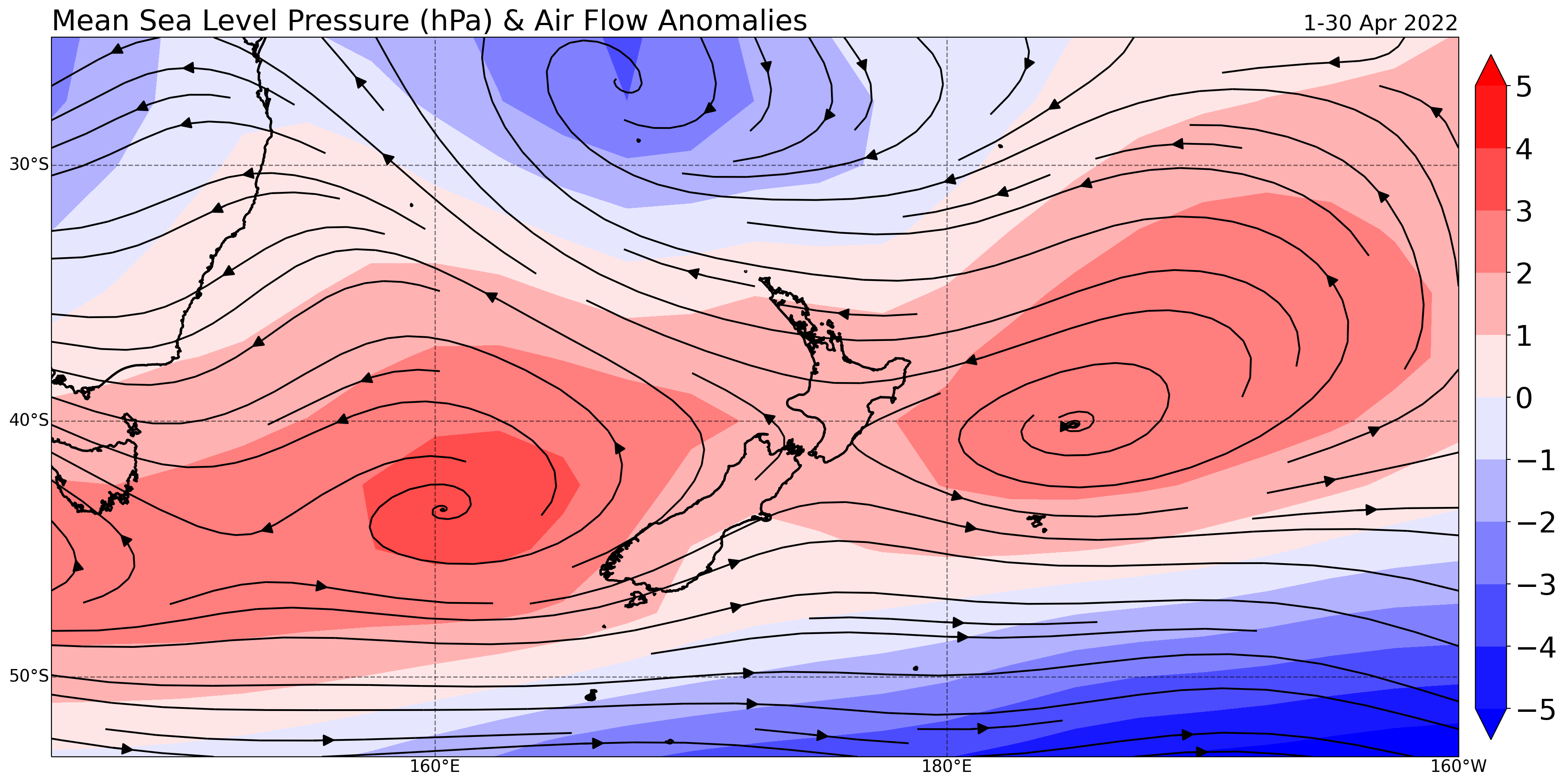
Figure 1: MSLP and air flow anomalies across New Zealand during April (data: NCEP reanalysis).
Further Highlights:
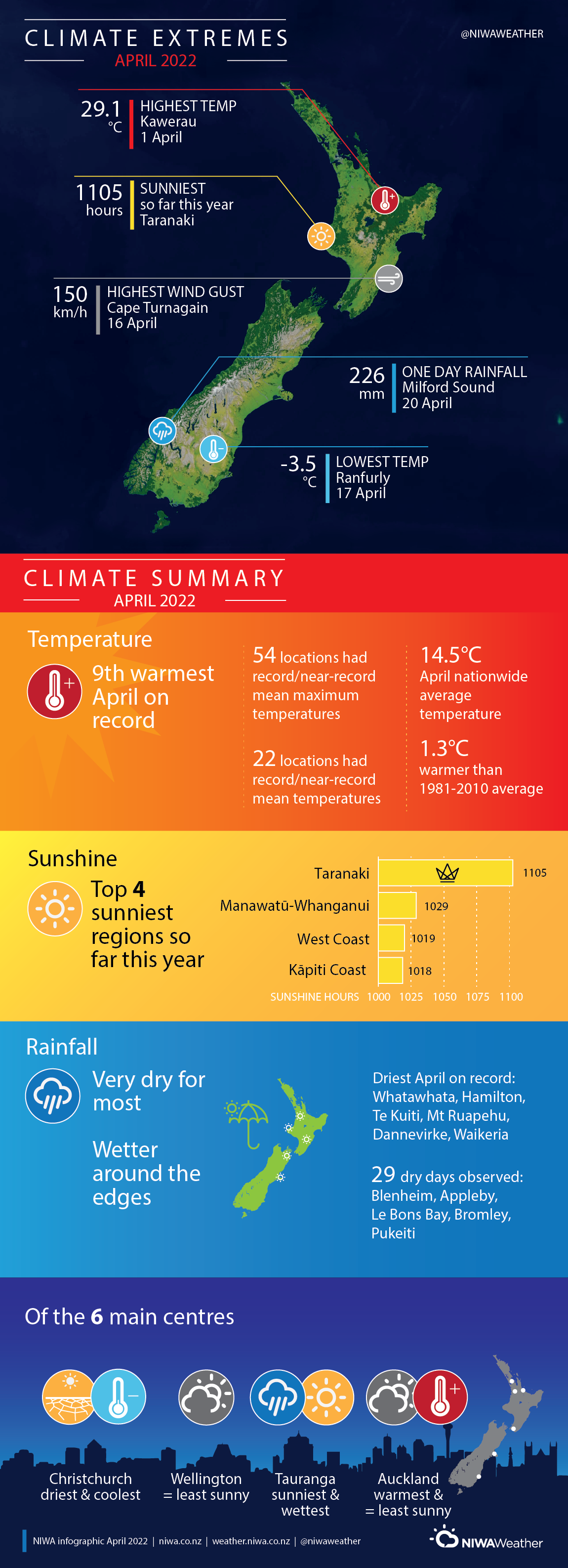
- The highest temperature was 29.1°C, observed at Kawerau on 1 April.
- The lowest temperature was -3.5°C, observed at Ranfurly on 17 April.
- The highest 1-day rainfall was 226 mm, recorded at Milford Sound on 20 April.
- The highest wind gust was 150 km/h, observed at Cape Turnagain on 16 April.
- Of the six main centres in April 2022, Auckland was the warmest and equal-least sunny, Christchurch was the coolest and driest, Tauranga was the wettest and sunniest, and Wellington was the equal-least sunny.
- Of the available, regularly reporting sunshine observation sites, the sunniest four locations so far in 2022 are Taranaki (1105 hours), Manawatū-Whanganui (1029 hours), West Coast (1019 hours), and Kāpiti Coast (1018 hours).
Download
- Climate Summary April 2022 (PDF 5.55 MB)
- Climate Statistics - April 2022 (PDF 158 KB)