Outlook Summary
- El Niño, which was active since September 2023, has ended and given way to ENSO neutral conditions, which are expected to last through winter. A La Niña Watch has been issued with a 60-70% chance of La Niña developing during spring.
- Winter air pressure is expected to be higher than normal near New Zealand, particularly the North Island, and lower than normal south of the country. This will most likely come with more westerly winds than normal. Southerly winds are expected to occur less frequently in winter than they did during autumn, which will have an influence on temperature patterns.
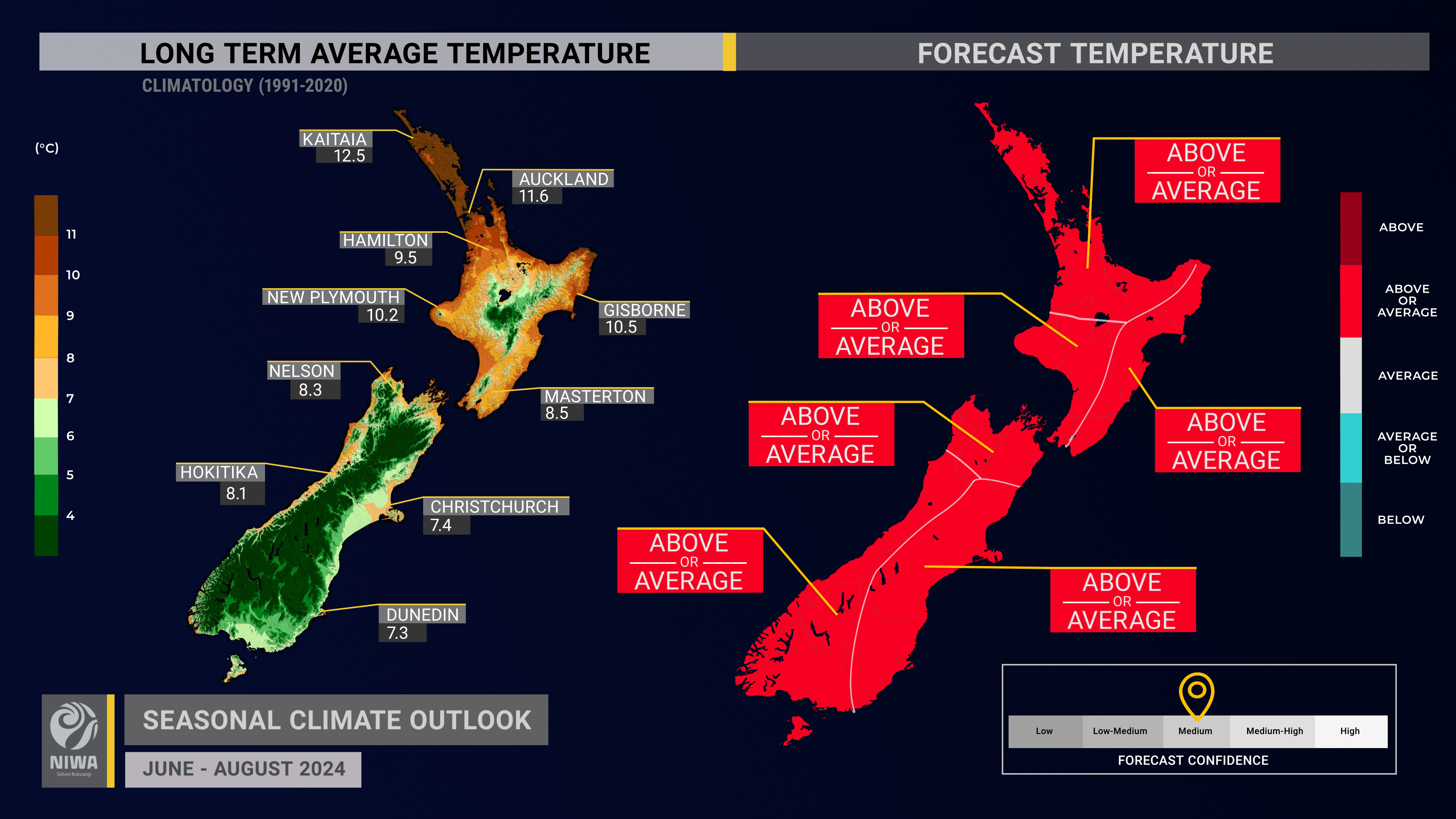
- Winter temperatures are about equally likely to be near average or above average across the country. A spell of warmer than average temperatures is expected during the first half of June followed by a return to more typical conditions in the second half of the month. Cold snaps, while expected occasionally through the season, will likely be brief.
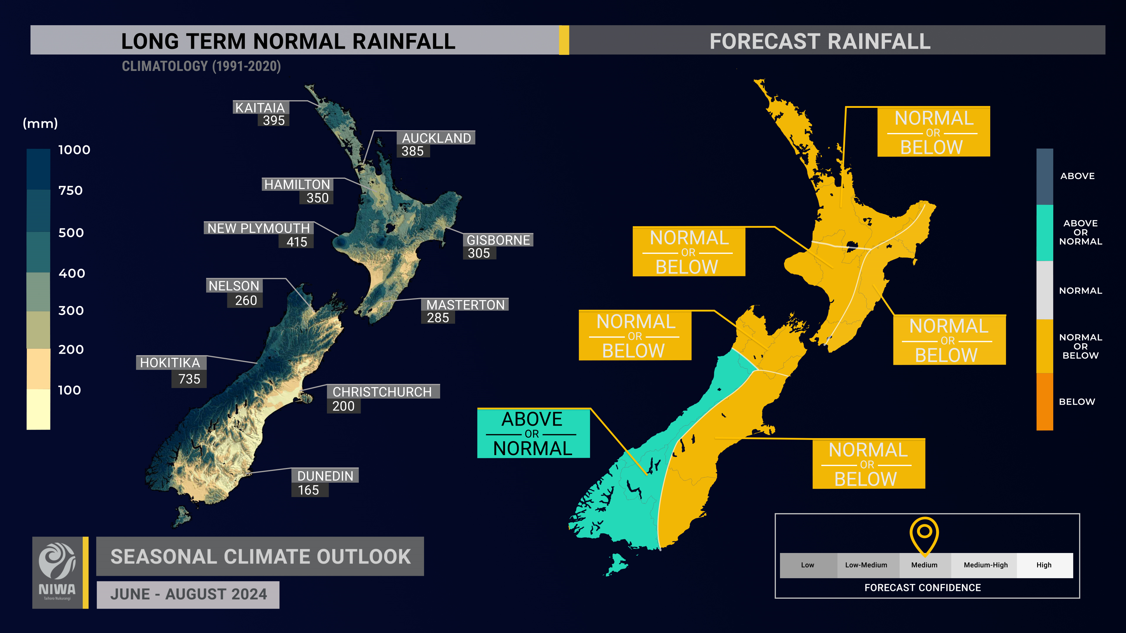
- Winter rainfall is about equally likely to be near normal or above normal in the west of the South Island and about equally likely to be near normal or below normal in all other regions.
- Because of the prevalence of high pressure, rainfall events will likely occur irregularly. There is a chance for a heavy rainfall event in the North Island and northern South Island during the second week of June. Monitor NIWA35 for updates.
- In association with a stronger than normal pressure gradient (difference in air pressure over distance), winds are expected to be stronger than normal, particularly in the South Island.
- Coastal sea surface temperatures (SSTs) ranged from 0.23˚C to 0.50˚C below average during May.
- Soil moisture levels are most likely to be below normal in the north and east of the South Island, near normal in the west of both islands, and equally likely to be near normal or below normal in the north and east of the North Island.
- River flows are most likely to be below normal in the north of both islands and the east of the South Island, near normal in the west of the North Island, equally likely to be near normal or below normal in the east of the North Island, and about equally likely to be near normal or above normal in the west of the South Island.
- Soil moisture and river flow deficits, such as in the lower North Island and South Island, will continue to be slow to be alleviated.
Regional predictions for June – August 2024
The tables below show the probabilities (or percent chances) for each of three categories: above average, near average, and below average. In the absence of any forecast guidance there would be an equal likelihood (33% chance) of the outcome for any of the three categories. Forecast information from local and global guidance models is used to indicate the deviation from equal chance that is expected for the coming three-month period. All outlooks are for the three months as a whole. There will inevitably be relatively wet and dry days, and hot and cold days, within a season. The exact range in temperature and rainfall within each of the three categories varies with location and season. However, as a guide, the “near average” or middle category for the temperature predictions includes deviations up to ±0.5°C for the long-term mean, whereas for rainfall the “near normal” category lies between 80 per cent and 120 per cent of the long-term (1991-2020) mean.
Northland, Auckland, Waikato, Bay of Plenty
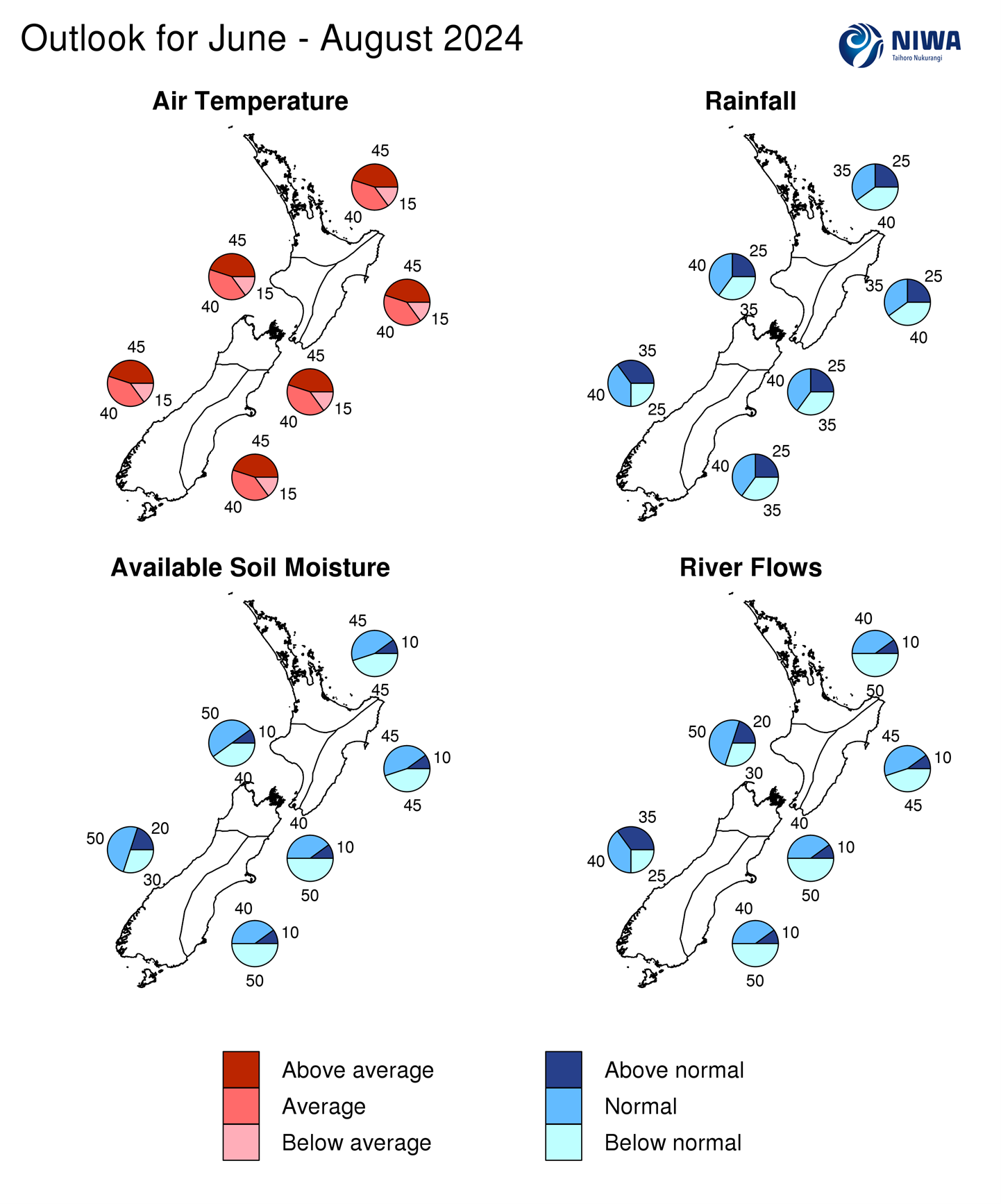
- Temperatures are about equally likely to be above average (45% chance) or near average (40% chance).
- An increased prevalence of high pressure systems will likely cause cool, occasionally frosty mornings but warmer afternoons, particularly from the second half of June.
- Rainfall totals are about equally likely to be below normal (40% chance) or near normal (35% chance). June has an elevated chance of being drier than normal and rainfall events will likely occur irregularly through the season.
- Soil moisture levels are equally likely to be near normal or below normal while river flows are most likely to be below normal.
| Temperature | Rainfall | Soil moisture | River flows | |
| Above average | 45 | 25 | 10 | 10 |
| Near average | 40 | 35 | 45 | 40 |
| Below average | 15 | 40 | 45 | 50 |
Central North Island, Taranaki, Whanganui, Manawatu, Wellington
Probabilities are assigned in three categories: above average, near average, and below average.
- Temperatures are about equally likely to be above average (45% chance) or near average (40% chance).
- An increased prevalence of high pressure systems will likely cause cool, occasionally frosty mornings but warmer afternoons, particularly from the second half of June.
- Rainfall totals are about equally likely to be near normal (40% chance) or below normal (35% chance). June has an elevated chance of being drier than normal.
- Soil moisture levels and river flows are most likely to be near normal (50% chance). Soil moisture and river flow deficits will be slow to be alleviated.
| Temperature | Rainfall | Soil moisture | River flows | |
| Above average | 45 | 25 | 10 | 20 |
| Near average | 40 | 40 | 50 | 50 |
| Below average | 15 | 35 | 40 | 30 |
Gisborne, Hawke’s Bay, Wairarapa
Probabilities are assigned in three categories: above average, near average, and below average.
- Temperatures are about equally likely to be above average (45% chance) or near average (40% chance). Westerly quarter winds will likely cause spells of milder temperatures.
- An increased prevalence of high pressure systems will likely cause cool, occasionally frosty mornings but warmer afternoons, particularly from the second half of June.
- Rainfall totals are about equally likely to be below normal (40% chance) or near normal (35% chance). Westerly quarter winds will likely result in spells of drier than normal conditions, particularly from the second half of June.
- Soil moisture levels and river flows are equally likely to be near normal or below normal (45% chance each).
| Temperature | Rainfall | Soil moisture | River flows | |
| Above average | 45 | 25 | 10 | 10 |
| Near average | 40 | 35 | 45 | 45 |
| Below average | 15 | 40 | 45 | 45 |
Tasman, Nelson, Marlborough, Buller
Probabilities are assigned in three categories: above average, near average, and below average.
- Temperatures are about equally likely to be above average (45% chance) or near average (40% chance).
- Rainfall totals are about equally likely to be near normal (40% chance) or below normal (35% chance). June has an elevated chance of being drier than normal.
- Soil moisture levels and river flows are most likely to be below normal (50% chance). Soil moisture and river flow deficits will be slow to be alleviated.
| Temperature | Rainfall | Soil moisture | River flows | |
| Above average | 45 | 25 | 10 | 10 |
| Near average | 40 | 40 | 40 | 40 |
| Below average | 15 | 35 | 50 | 50 |
West Coast, Southern Alps and foothills, inland Otago, Southland
Probabilities are assigned in three categories: above average, near average, and below average.
- Temperatures are about equally likely to be above average (45% chance) or near average (40% chance).
- Rainfall totals are about equally likely to be near normal (40% chance) or above normal (35% chance). The region may be exposed to strong fronts and lows on occasion, particularly in July and/or August.
- Soil moisture levels are most likely to be near normal (50% chance) while river flows are about equally likely to be near normal (40% chance) or above normal (35% chance).
| Temperature | Rainfall | Soil moisture | River flows | |
| Above average | 45 | 35 | 20 | 35 |
| Near average | 40 | 40 | 50 | 40 |
| Below average | 15 | 25 | 30 | 25 |
Coastal Canterbury and the nearby plains, east Otago
Probabilities are assigned in three categories: above average, near average, and below average.
- Temperatures are about equally likely to be above average (45% chance) or near average (40% chance). Westerly quarter winds will likely cause spells of milder temperatures.
- Rainfall totals are about equally likely to be near normal (40% chance) or below normal (35% chance). June has an elevated chance of being drier than normal.
- Soil moisture levels and river flows are most likely to be below normal (50% chance). Soil moisture and river flow deficits will be slow to be alleviated.
The full probability breakdown is:
| Temperature | Rainfall | Soil moisture | River flows | |
| Above average | 45 | 25 | 10 | 10 |
| Near average | 40 | 40 | 40 | 40 |
| Below average | 15 | 35 | 50 | 50 |
Graphical representation of the regional probabilities
Background
Sea surface temperatures (SSTs) transitioned into the ENSO neutral range in the central equatorial Pacific (Niño 3.4 Index) during May (value of +0.31˚C), seeing El Niño, which began in September 2023, officially come to an end. The monthly Niño 1+2 Index (eastern equatorial Pacific) dropped to -0.64˚C, taking a relatively big step in the direction of La Niña.
The Southern Oscillation Index (SOI) was on the La Niña side of neutral during May (+0.8) and neutral from March-May (+0.2).
Because of above normal trade wind speeds, an increasing Southern Oscillation Index (above +0.5 for May), a shift in convective patterns, and an expectation for these conditions to continue, a La Niña Watch has been raised. ENSO neutral conditions are favoured to last through winter, but oceanic La Niña may develop during spring (60-70% chance).
During May, trade wind strength was generally above normal along the equator in the equatorial Pacific. This was associated with additional cooling of the surface ocean water. A period of enhanced trade winds in the western Pacific during the first half of June will likely result in additional warming there. Cooling is expected to continue in other regions.
The subsurface equatorial Pacific remained 4˚C to 6˚C cooler than average just below the surface in the east. Meanwhile, above average temperatures continued in the central part of the basin and developed in the west. Upper-oceanic heat content was 1˚C to 2˚C below average in the eastern and central equatorial Pacific. In the western equatorial Pacific, heat content increased to 0.5˚C to 1.0˚C above average. This was consistent with an oceanic trend toward La Niña.
During May, convective forcing favoured the western tropical Pacific with suppressed activity over the central and eastern part of the basin. This was consistent with an atmosphere that was progressing toward La Niña and reflective of an early month pulse of the Madden-Julian Oscillation (MJO) over the western Pacific.
With an ENSO neutral ocean-atmosphere system in charge, higher frequency variability (e.g., MJO) is likely to be more dominant.
During June, a pulse of the MJO is forecast to propagate from the Maritime Continent, across the tropical Pacific, and into the Americas and Atlantic Ocean. This corresponds to phases 5-6-7-8-1 on the phase space, which, for New Zealand, have historically been associated with northerly quarter winds followed by building anticyclonic conditions and eventually westerlies. Thus, June has the makings of a changeable month, weather-wise, for New Zealand. In terms of temperatures, this progression will likely yield a relatively warm start to the month followed by conditions that are more typical for the time of year. A fleeting connection with the tropics may result in a heavy rainfall event for the North Island and northern South Island during the second week of the month, but confidence is low as of this writing.
As the MJO transits eastward during the second half of June, the chance for moisture-laden low pressure systems from the north will likely be low for New Zealand.
Another MJO pulse is expected to develop over the western Indian Ocean very late in June, possibly moving through phases 2-4 into early July. Phases 2 and 3 have spelled dryness for much of the North Island while phase 3 historically brought heavy rainfall to the western and lower South Island, including the hydro catchment areas.
In a broad sense, convective forcing looks to favour phases 1-3 during July-August in association with an excessively warm Atlantic Ocean and western Indian Ocean. These phases have come with more westerly quarter winds for New Zealand, periods of below normal rainfall in the North Island and northern and eastern South Island, and near average or above average temperatures.
Climate-sensitive sectors are encouraged to make use of the New Zealand drought dashboard, which provides 35-day outlooks of rainfall and drought, updated once daily: https://niwa.co.nz/seasonal-climate-outlook/seasonal-climate-outlook
The Southern Annular Mode (SAM) was variable during May. More variability is expected in June, with predominantly negative values in association with low pressure during the second week of the month.
SSTs in New Zealand’s coastal waters were near average or slightly below average during May. Near average SSTs are favoured in the months ahead, although a slight warming trend may occur (relative to average for the time of year). For more info, see the NIWA Sea Surface Temperature Update.
NZ 30-day coastal SST anomalies (to 28 May)
| North NI | -0.31˚C |
| West NI | -0.27˚C |
| East NI | -0.23˚C |
| North SI | -0.35˚C |
| West SI | -0.50˚C |
| East SI | -0.25˚C |
Forecast Confidence
Temperature

Forecast confidence for temperatures is medium. The tail end of El Niño has come with circulation patterns that have favoured cool, southwesterly winds across New Zealand, with seasonal climate models biased too warm. Guidance continues to indicate that westerly and/or northwesterly winds will become more common during winter with the southerly influence easing. This makes a colder than average winter unlikely.
Rainfall

Forecast confidence for rainfall is medium. The prevalence of high pressure systems during the winter season favours a reduction in wet days for many regions. However, a predicted increase in northwesterly winds during mid-to-late winter could see western areas of both islands, particularly the South Island, turn wetter. Note: climate model guidance generally has lower skill during ENSO neutral periods.