Outlook summary
- Following La Niña-like atmospheric patterns near New Zealand during June, a La Niña Watch continues. There’s a 60-70% chance that La Niña will develop during spring.
- July is expected to feature mixed air flows, including a potential spell of moist, northerly quarter winds in the mid-month. During August and/or September, high pressure may become more common near the North Island, seeing a possible return to westerlies.
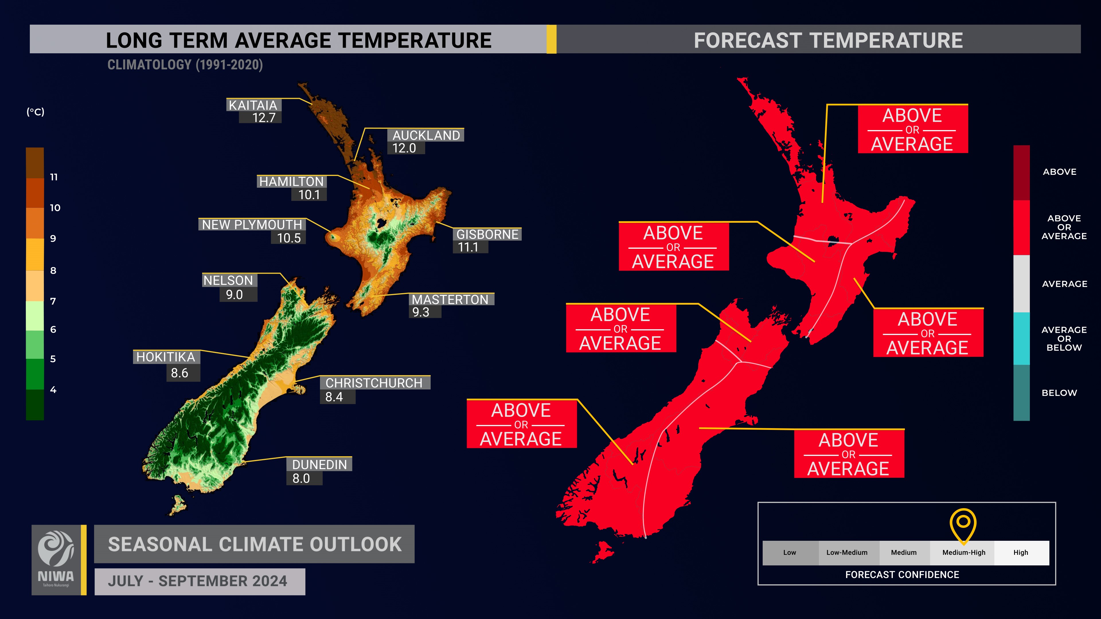
- Temperatures are about equally likely to be near average or above average in all regions of the country. Cold snaps, like what’s expected in early July, will occur occasionally but likely won’t define the season. There may be fewer frosts and above average soil temperatures.
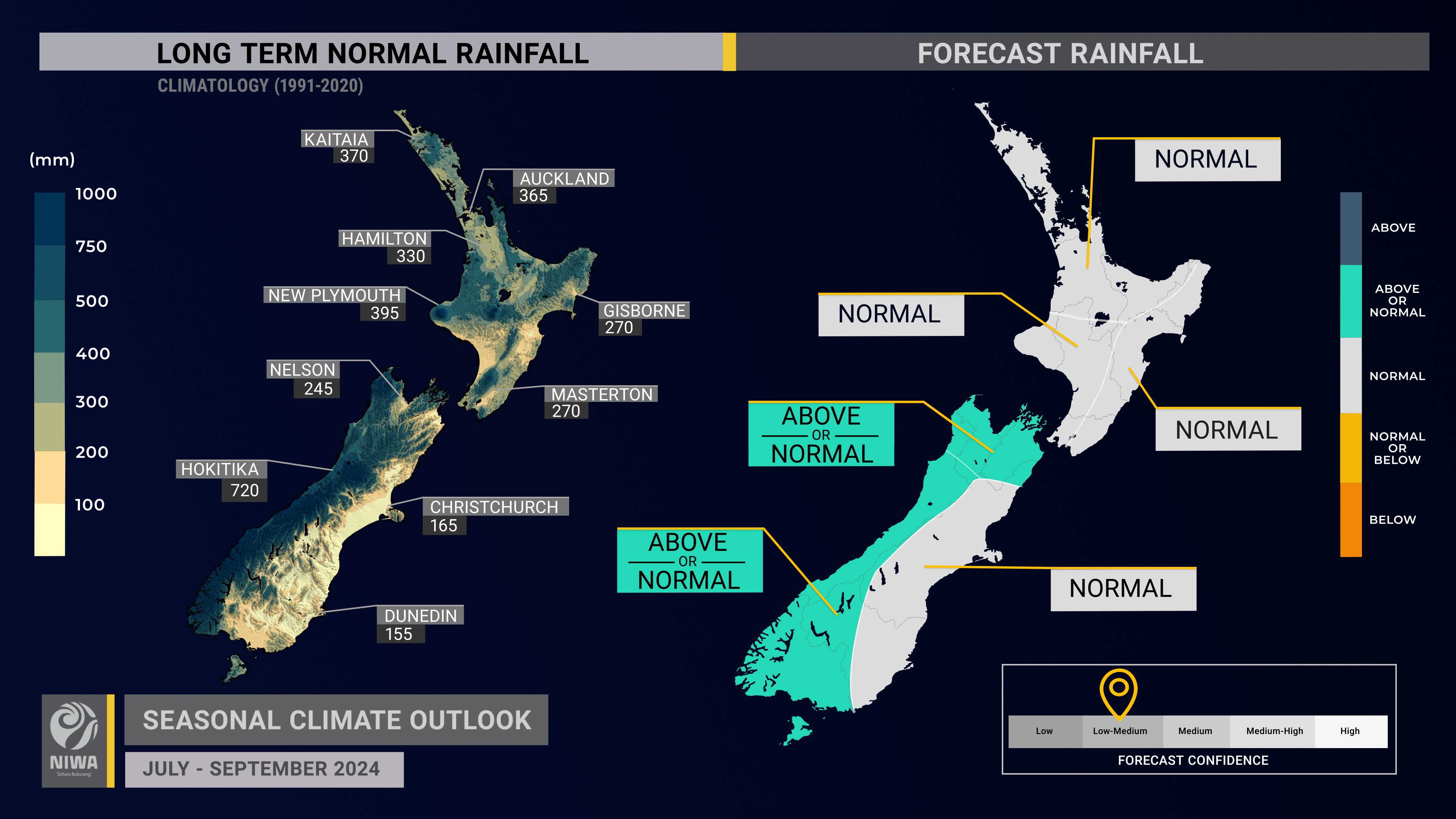
- Rainfall is about equally likely to be near normal or above normal in the north and west of the South Island and most likely to be near normal in all other regions. This represents a wetter trend compared to last month’s outlook, owing to La Niña-like tendencies in the atmosphere. A tropical moisture plume in mid-July may cause heavy rainfall in some regions, increasing the chance for flooding. Monitor NIWA35 for updates.
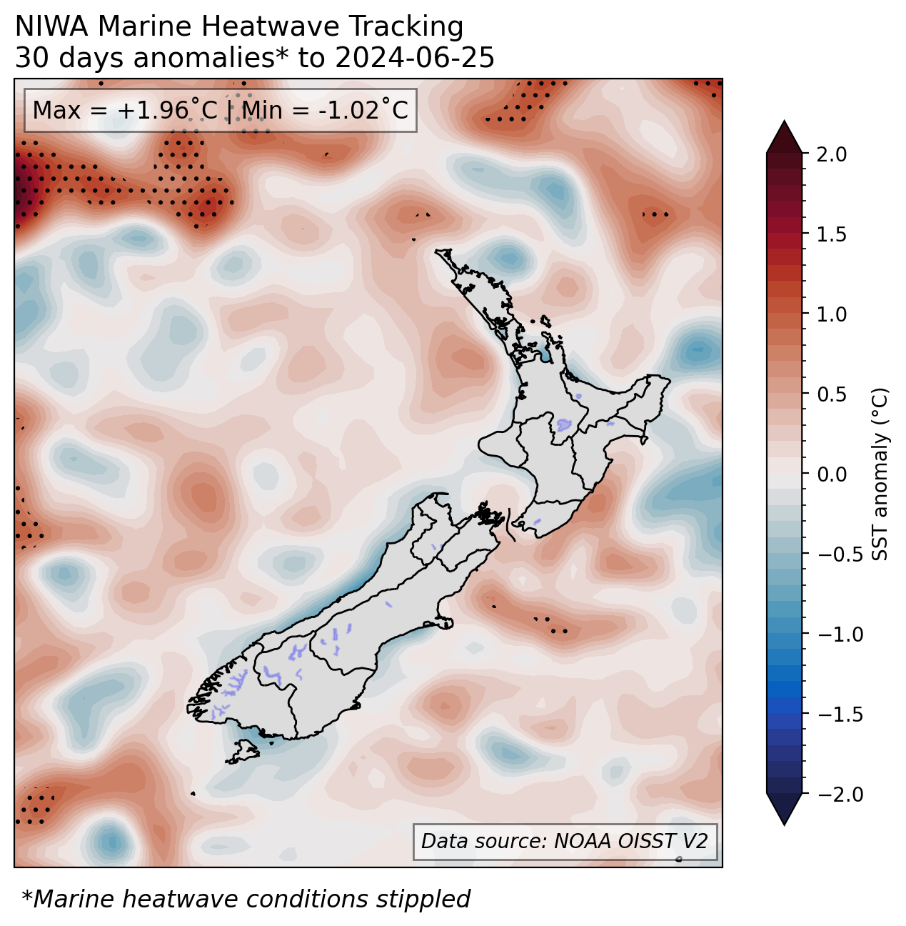
- Coastal sea surface temperatures (SSTs) ranged from 0.33˚C below average to 0.16˚C above average during June. Monitor the SST update for more information.
- Soil moisture levels are most likely to be near normal in the east of the North Island and west and east of the South Island and about equally likely to be near normal or below normal in all remaining regions.
- River flows are most likely to be below normal in the north of the North Island, near normal in the west and east of the North Island, equally likely to be near normal or below normal in the north and east of the South Island, and about equally likely to be near normal or above normal in the west of the South Island.
Regional predictions for July – September 2024
The tables below show the probabilities (or percent chances) for each of three categories: above average, near average, and below average. In the absence of any forecast guidance there would be an equal likelihood (33% chance) of the outcome for any of the three categories. Forecast information from local and global guidance models is used to indicate the deviation from equal chance that is expected for the coming three-month period. All outlooks are for the three months as a whole. There will inevitably be relatively wet and dry days, and hot and cold days, within a season. The exact range in temperature and rainfall within each of the three categories varies with location and season. However, as a guide, the “near average” or middle category for the temperature predictions includes deviations up to ±0.5°C for the long-term mean, whereas for rainfall the “near normal” category lies between 80 per cent and 120 per cent of the long-term (1991-2020) mean.
Northland, Auckland, Waikato, Bay of Plenty
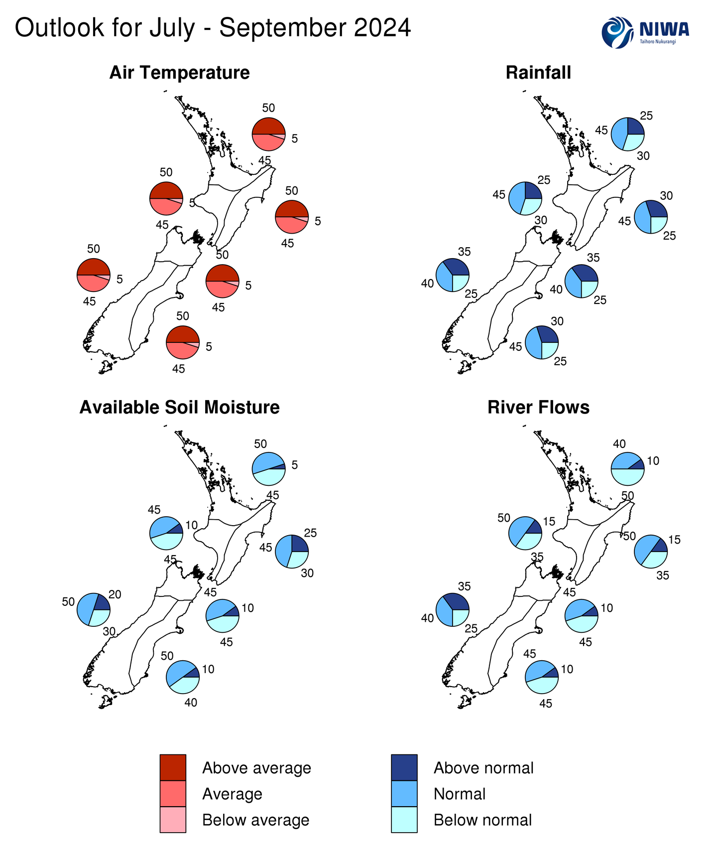
- Temperatures are about equally likely to be above average (50% chance) or near average (45% chance). A lack of southerly winds may contribute to a reduced risk for frost.
- Rainfall totals are most likely to be near normal (45% chance). A heavy rainfall event is possible in mid-July.
- Soil moisture levels are about equally likely to be near normal or below normal while river flows are most likely to be below normal.
| Temperature | Rainfall | Soil moisture | River flows | |
| Above average | 50 | 25 | 05 | 10 |
| Near average | 45 | 45 | 50 | 40 |
| Below average | 05 | 30 | 45 | 50 |
Central North Island, Taranaki, Whanganui, Manawatu, Wellington
Probabilities are assigned in three categories: above average, near average, and below average.
- Temperatures are about equally likely to be above average (50% chance) or near average (45% chance). A lack of southerly winds may contribute to a reduced risk for frost.
- Rainfall totals are most likely to be near normal (45% chance). A heavy rainfall event is possible in mid-July.
- Soil moisture levels are equally likely to be near normal or below normal (45% chance each) while river flows are most likely to be near normal (50% chance).
| Temperature | Rainfall | Soil moisture | River flows | |
| Above average | 50 | 25 | 10 | 15 |
| Near average | 45 | 45 | 45 | 50 |
| Below average | 05 | 30 | 45 | 35 |
Gisborne, Hawke’s Bay, Wairarapa
Probabilities are assigned in three categories: above average, near average, and below average.
- Temperatures are about equally likely to be above average (50% chance) or near average (45% chance). A lack of southerly winds may contribute to a reduced risk for frost. Westerly quarter winds will likely cause spells of milder temperatures, particularly in August and/or September.
- Rainfall totals are most likely to be near normal (45% chance). A heavy rainfall event is possible in mid-July.
- Soil moisture levels and river flows are most likely to be near normal (45-50% chance).
| Temperature | Rainfall | Soil moisture | River flows | |
| Above average | 50 | 30 | 25 | 15 |
| Near average | 45 | 45 | 45 | 50 |
| Below average | 05 | 25 | 30 | 35 |
Tasman, Nelson, Marlborough, Buller
Probabilities are assigned in three categories: above average, near average, and below average.
- Temperatures are about equally likely to be above average (50% chance) or near average (45% chance). A lack of southerly winds may contribute to a reduced risk for frost.
- Rainfall totals are about equally likely to be near normal (40% chance) or above normal (35% chance). A heavy rainfall event is possible in mid-July.
- Soil moisture levels and river flows are equally likely to be near normal or below normal (45% chance each).
| Temperature | Rainfall | Soil moisture | River flows | |
| Above average | 50 | 35 | 10 | 10 |
| Near average | 45 | 40 | 45 | 45 |
| Below average | 05 | 25 | 45 | 45 |
West Coast, Southern Alps and foothills, inland Otago, Southland
Probabilities are assigned in three categories: above average, near average, and below average.
- Temperatures are about equally likely to be above average (50% chance) or near average (45% chance). A lack of southerly winds may contribute to a reduced risk for frost.
- Rainfall totals are about equally likely to be near normal (40% chance) or above normal (35% chance). The region may be exposed to strong fronts and lows on occasion, such as in mid-July.
- Soil moisture levels are most likely to be near normal (50% chance) while river flows are about equally likely to be near normal (40% chance) or above normal (35% chance).
| Temperature | Rainfall | Soil moisture | River flows | |
| Above average | 50 | 35 | 20 | 35 |
| Near average | 45 | 40 | 50 | 40 |
| Below average | 05 | 25 | 30 | 25 |
Coastal Canterbury and the nearby plains, east Otago
Probabilities are assigned in three categories: above average, near average, and below average.
- Temperatures are about equally likely to be above average (50% chance) or near average (45% chance). A lack of southerly winds may contribute to a reduced risk for frost. Westerly quarter winds will likely cause spells of milder temperatures, particularly in August and/or September.
- Rainfall totals are most likely to be near normal (45% chance).
- Soil moisture levels are most likely to be near normal (50% chance) while river flows are equally likely to be near normal or below normal (45% chance each).
The full probability breakdown is:
| Temperature | Rainfall | Soil moisture | River flows | |
| Above average | 50 | 30 | 10 | 10 |
| Near average | 45 | 45 | 50 | 45 |
| Below average | 05 | 25 | 40 | 45 |
Graphical representation of the regional probabilities
Background
Sea surface temperatures (SSTs) remained in the ENSO neutral range in the central equatorial Pacific during June with a Niño 3.4 Index of +0.15˚C. The monthly Niño 1+2 Index was -0.73˚C, within the La Niña range and representative of the overall cooling trend that was occurring in the eastern Pacific.
The Southern Oscillation Index (SOI) was on the El Niño side of neutral during June (-0.7) and neutral from April-June (0.0). Recent variability is characteristic of an ENSO neutral ocean-atmosphere system. ENSO neutral conditions are favoured to continue through winter.
Oceanic La Niña may develop during spring (60-70% chance). It’s worth noting that several models that NIWA monitors are running too warm in their analysis/forecast of SSTs in the equatorial Pacific during June. The models that are tracking closest to the observations suggest a La Niña of moderate intensity may develop later this year. Therefore, a La Niña Watch continues.
Trade wind strengthwas generally near normal or slightly above normal in the eastern and east-central equatorial Pacific during June, consistent with a continued oceanic cooling trend. Signs are that trade winds will be enhanced during July, which should drive additional cooling.
The subsurface equatorial Pacific remained 4˚C to 6˚C cooler than average just below the surface in the east with the thermocline located just tens of metres below the surface. Meanwhile, above average temperatures continued in the central part of the basin and intensified in the west. This was reflective of a transition toward a possible La Niña in a few months.
During June, convective forcing favoured the west-central equatorial Pacific, producing a La Niña-like response in the atmosphere. This was linked to a slow-moving pulse of the Madden-Julian Oscillation (MJO) which produced a La Niña-like circulation pattern in New Zealand. Such a pattern was quicker to develop than modelling had previously indicated.
During July, the MJO is once again forecast to track across the Pacific, particularly in the 2nd and 3rd week of the month. This is forecast to be associated with lowering pressure north and west of New Zealand and may produce a spell of heavy rain. Because of a possible tropical moisture connection, there is an increase in the chance for flooding.
Overall, this represents a trend away from the forcing patterns that produced abnormally dry conditions in several regions during the first half of the year.
The MJO pulse may reach the eastern Pacific, Africa, and the western Indian Ocean during late July, eventually producing more westerly flows and wetter conditions in the west of both islands, including in the South Island hydro catchments.
For August-September, model guidance favours a reduction in convective forcing north of New Zealand and an enhancement over the western Indian Ocean, Africa, and the Atlantic. This may be related to a very active West African Monsoon and/or record warm ocean waters in the tropical Atlantic. Such a pattern may enable more frequent high pressure near the North Island and low pressure near or south of the South Island, causing westerly quarter winds.
Although early July will likely feature some colder than average air, there’s little to suggest that below average temperatures will be a theme over the next three months as southerly flows are not expected to be dominant.
Climate-sensitive sectors are encouraged to make use of the New Zealand drought dashboard, which provides 35-day outlooks of rainfall and drought, updated once daily: https://niwa.co.nz/weather-forecasting/seasonal-climate-outlook
The Southern Annular Mode (SAM) was variable during June. More variability is expected during July, with a brief spell of negative SAM early in the month, followed by a rebound toward positive SAM thereafter.
SSTs in New Zealand’s coastal waters were near average or slightly below average during June, but warmed slightly in all regions compared to May. Seas are favoured to display a gradual warming trend in the months ahead and some guidance suggests marine heatwave conditions may form late in the year. For more info, see the NIWA Sea Surface Temperature Update.
NZ 30-day coastal SST anomalies (to 25 June)
| North NI | -0.05˚C |
| West NI | -0.05˚C |
| East NI | 0.16˚C |
| North SI | -0.06˚C |
| West SI | -0.33˚C |
| East SI | -0.06˚C |
Forecast Confidence
Temperature

Forecast confidence for temperatures is medium-high. Winter started off on a mild note in June which is likely to be a sign of things to come. La Niña-like northeasterly winds are expected on occasion and southerlies are expected to occur infrequently, making a colder than average July-September unlikely.
Rainfall

Forecast confidence for rainfall is low-medium. The variability associated with ENSO-neutral conditions was on display during June, causing variable rainfall patterns. This will likely continue to be a theme in the months ahead, with one month’s rainfall conditions unlikely to be reflective of the next. Note: climate model guidance generally has lower skill during ENSO neutral periods.
