Outlook Summary
- A La Niña Watch remains in effect with a 60-70% chance that an event officially develops by December. La Niña-like patterns will favour more high pressure south of New Zealand over the next three months, coming with a gradual reduction in the typical westerly winds.
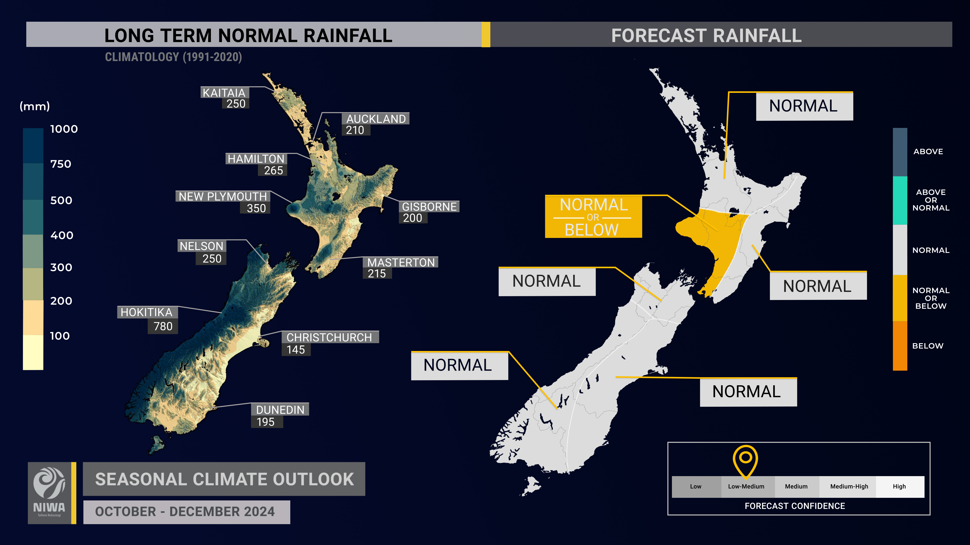
- Rainfall is about equally likely to be near normal or below normal in the west of the North Island. For all remaining regions, near normal rainfall is most likely.
- During La Niña-like conditions, blocking high pressure to the south of New Zealand may enable low pressure systems to become stalled near the country. This introduces the chance for heavy rainfall events, which could occur during October. Monitor NIWA35 for updates.
- The chance for more high pressure near the South Island and easterly quarter air flows later in the three-month period may see dry spells develop, especially in the west of both islands.
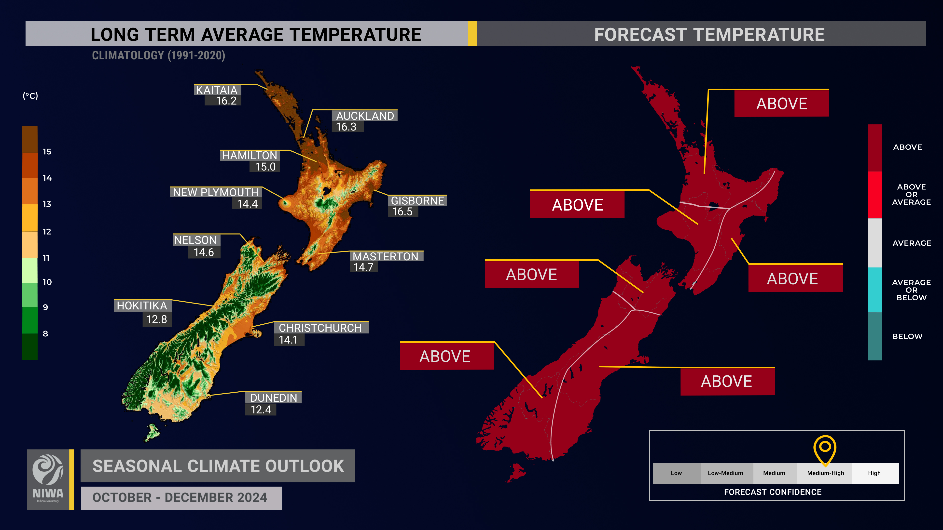
- Air temperatures are most likely to be above average across the country. Warm air masses will flow from Australia into New Zealand at times during October. An increased prevalence of northeasterly winds may lead to more days above 25˚C in November-December.
- As easterly quarter winds become more common than normal during this three-month period, overnight minimum temperatures may be unusually warm in the east of both islands, while daytime temperatures may not be as unusually warm in these areas.
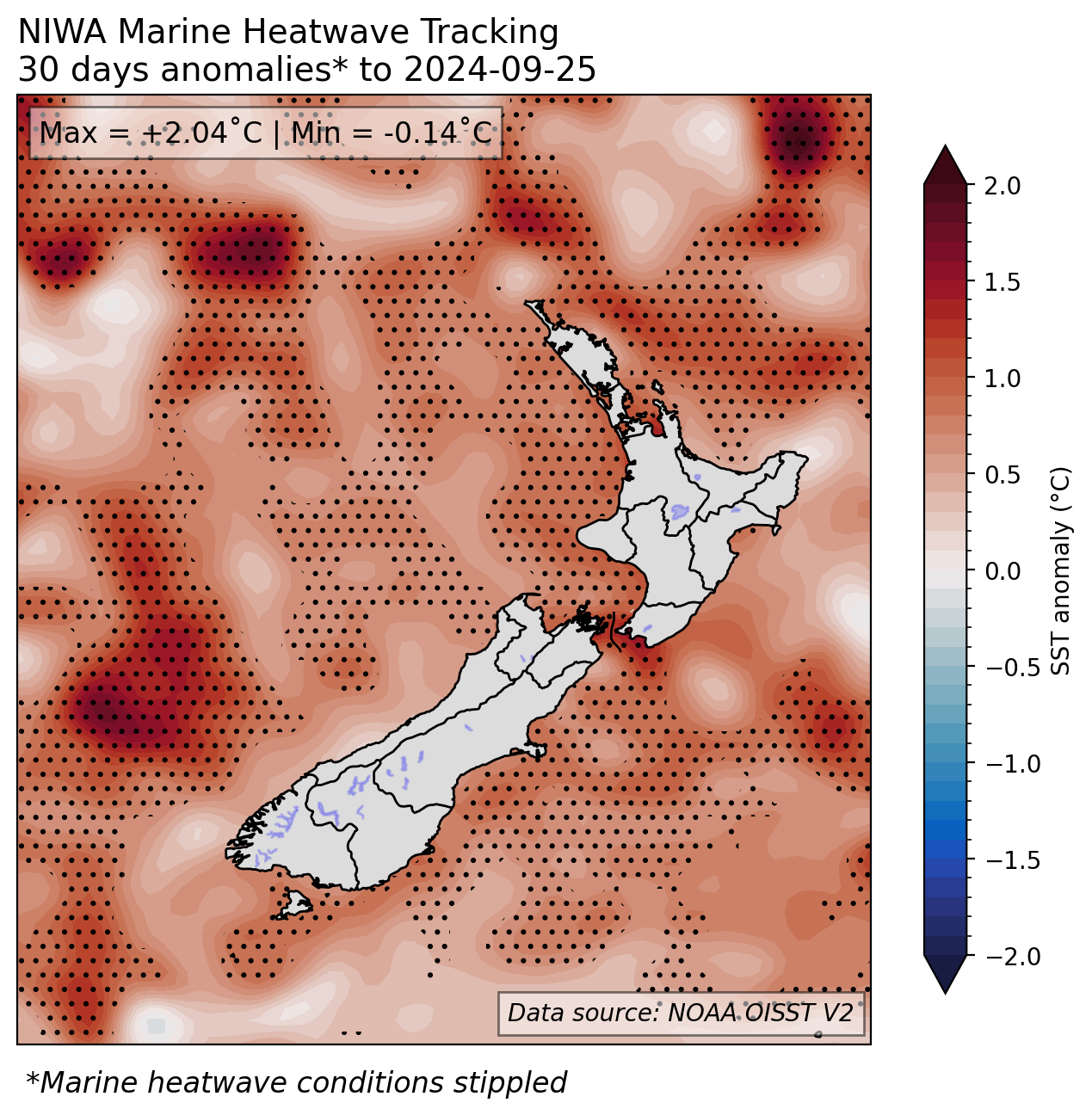
- Coastal sea surface temperatures (SSTs) ranged from 0.54˚C to 1.02˚C above average during September. At the end of the month, marine heatwave conditions were occurring near the northern and western North Island and northern South Island. Monitor the SST update for updates, which suggests marine heatwave conditions may intensify in the months ahead, which often occurs during La Niña summers.
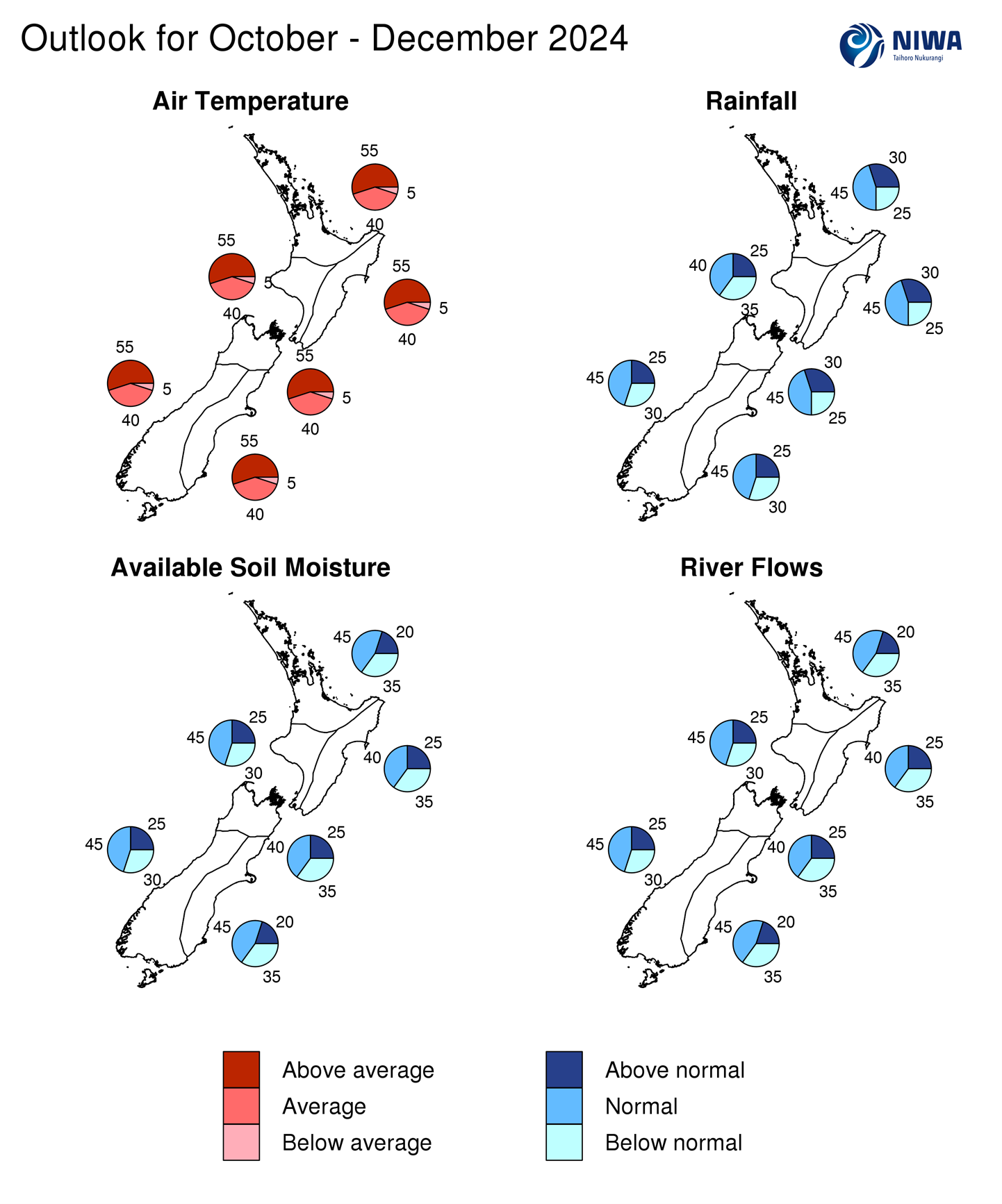
- Spring soil moisture levels and river flows are most likely to be near normal in all regions of the country except for the east of the North Island and north of the South Island where they are about equally likely to be near normal or below normal.
- Despite near-surface soil moisture increases in the last month, soil moisture levels at depth continue to be below normal in the east of both islands.
Regional predictions for October – December 2024
The tables below show the probabilities (or percent chances) for each of three categories: above average, near average, and below average. In the absence of any forecast guidance there would be an equal likelihood (33% chance) of the outcome for any of the three categories. Forecast information from local and global guidance models is used to indicate the deviation from equal chance that is expected for the coming three-month period. All outlooks are for the three months as a whole. There will inevitably be relatively wet and dry days, and hot and cold days, within a season. The exact range in temperature and rainfall within each of the three categories varies with location and season. However, as a guide, the “near average” or middle category for the temperature predictions includes deviations up to ±0.5°C for the long-term mean, whereas for rainfall the “near normal” category lies between 80 per cent and 120 per cent of the long-term (1991-2020) mean.
Northland, Auckland, Waikato, Bay of Plenty
- Temperatures are most likely to be above average (55% chance). More northeasterly winds may lead to higher humidity levels and warmer nights.
- Rainfall totals are most likely to be near normal (45% chance). Consistent with La Niña-like conditions, slow-moving and moisture-laden low pressure systems may occasionally approach the region from the north, bringing a chance for heavy rain.
- Soil moisture levels and river flows are most likely to be near normal (45% chance).
| Temperature | Rainfall | Soil moisture | River flows | |
| Above average | 55 | 30 | 20 | 20 |
| Near average | 40 | 45 | 45 | 45 |
| Below average | 05 | 25 | 35 | 35 |
Central North Island, Taranaki, Whanganui, Manawatu, Wellington
Probabilities are assigned in three categories: above average, near average, and below average.
- Temperatures are most likely to be above average (55% chance). More northeasterly winds later in the three-month period may contribute to more days above 25˚C than normal.
- Rainfall totals are about equally likely to be near normal (40% chance) or below normal (35% chance). More northeasterly winds may contribute to dry spells, particularly later in the three-month period.
- Soil moisture levels and river flows are most likely to be near normal (45% chance).
| Temperature | Rainfall | Soil moisture | River flows | |
| Above average | 55 | 25 | 25 | 25 |
| Near average | 40 | 40 | 45 | 45 |
| Below average | 05 | 35 | 30 | 30 |
Gisborne, Hawke’s Bay, Wairarapa
Probabilities are assigned in three categories: above average, near average, and below average.
- Temperatures are most likely to be above average (55% chance). Occasional air masses from Australia will contribute to unusually warm conditions at times during October. More onshore winds later in the three-month period could lead to warmer nights but cooler days.
- Rainfall totals are most likely to be near normal (45% chance). Consistent with La Niña-like conditions, slow-moving and moisture-laden low pressure systems may occasionally approach the region from the north, bringing a chance for heavy rain.
- Soil moisture levels and river flows are about equally likely to be near normal (40% chance) or below normal (35% chance).
| Temperature | Rainfall | Soil moisture | River flows | |
| Above average | 55 | 30 | 25 | 25 |
| Near average | 40 | 45 | 40 | 40 |
| Below average | 05 | 25 | 35 | 35 |
Tasman, Nelson, Marlborough, Buller
Probabilities are assigned in three categories: above average, near average, and below average.
- Temperatures are most likely to be above average (55% chance). Occasional air masses from Australia will contribute to unusually warm conditions at times during October.
- Rainfall totals are most likely to be near normal (45% chance). Consistent with La Niña-like conditions, slow-moving and moisture-laden low pressure systems may occasionally approach the region from the north, bringing a chance for heavy rain. In the western part of the region, more northeasterly winds may cause dry spells later in the three-month period.
- Soil moisture levels and river flows are about equally likely to be near normal (40% chance) or below normal (35% chance).
| Temperature | Rainfall | Soil moisture | River flows | |
| Above average | 55 | 30 | 25 | 25 |
| Near average | 40 | 45 | 40 | 40 |
| Below average | 05 | 25 | 35 | 35 |
West Coast, Southern Alps and foothills, inland Otago, Southland
Probabilities are assigned in three categories: above average, near average, and below average.
- Temperatures are most likely to be above average (55% chance). More northeasterly winds later in the three-month period may contribute to more days above 25˚C than normal.
- Rainfall totals are most likely to be near normal (45% chance). Heavy rainfall events are possible during October, though more northeasterly winds may cause dry spells later in the three-month period.
- Soil moisture levels and river flows are most likely to be near normal (45% chance).
| Temperature | Rainfall | Soil moisture | River flows | |
| Above average | 55 | 25 | 25 | 25 |
| Near average | 40 | 45 | 45 | 45 |
| Below average | 05 | 30 | 30 | 30 |
Coastal Canterbury and the nearby plains, east Otago
Probabilities are assigned in three categories: above average, near average, and below average.
- Temperatures are most likely to be above average (55% chance). Occasional air masses from Australia will contribute to unusually warm conditions at times during October. More onshore winds later in the three-month period could lead to warmer nights but cooler days.
- Rainfall totals are most likely to be near normal (45% chance). Consistent with La Niña-like conditions, slow-moving and moisture-laden low pressure systems may occasionally approach the region from the north, bringing a chance for heavy rain.
- Soil moisture levels and river flows are most likely to be near normal (45% chance).
The full probability breakdown is:
| Temperature | Rainfall | Soil moisture | River flows | |
| Above average | 55 | 25 | 20 | 20 |
| Near average | 40 | 45 | 45 | 45 |
| Below average | 05 | 30 | 35 | 35 |
Graphical representation of the regional probabilities
Background
Sea surface temperatures(SSTs) remained in the neutral range in the central equatorial Pacific (Niño 3.4 Index) during September (-0.27˚C), decreasing from -0.06˚C at the end of August. As of 27 September, the 30-day Relative Oceanic Niño 3.4 Index[1] (RONI) was -0.81˚C, reflective of the central equatorial Pacific being cooler than the average of the global tropics. Trade wind strengthwas above normal or well above normal in the equatorial Pacific during September, contributing to a continued
oceanic cooling trend. The trend of stronger than normal trade winds is forecast to continue through October, which is expected to result in continued cooling.
The Southern Oscillation Index (SOI) was in the neutral range during September (-0.2) and July-September (+0.1). Continued SOI variability is characteristic of an ENSO neutral ocean-atmosphere system.
During September, upper-oceanic heat content was 1.0˚C to 2.0˚C below average in the eastern and central equatorial Pacific, a cooling trend compared to August, particularly in the central part of the basin. This signature is consistent with a developing La Niña event.
ENSO neutral conditions are favoured to continue through October, although a continued progression in a La Niña-like direction is expected. There’s a 60-70% chance for La Niña to develop by December, an increase in the percentage chance compared to last month. Strong trade winds are forecast to continue through October, enhancing oceanic cooling. However, atmospheric indicators like the SOI continue to be reflective of a neutral state. NIWA will continue to actively monitor these conditions and if necessary, transition New Zealand to “La Niña Alert”. Global oceanic warmth continues to be at near-record high levels, which may influence the atmospheric response and weather patterns associated with the developing La Niña. No two La Niña events are alike, a concept that may be more pertinent in a world that features widespread above average sea temperatures.
The Southern Annular Mode (SAM) was positive during the first half of September then negative during the rest of the month. The effect of a mid-winter Sudden Stratospheric Warming event on hemispheric patterns continued during September, with higher than normal pressure covering part of the pole and contributing to strong low pressure in the Southern Ocean. The SAM is forecast to make strides toward positive values in October, which is consistent with a La Niña-like background state.
The Indian Ocean Dipole (IOD) index as of late September was +1.09, which continued an increasing trend that started in August. Typically, positive IOD phases are associated with El Niño events – not a developing La Niña, implying that there is little historical precedent for the current state of climate drivers in the Indo-Pacific region.
During September, convective forcing favoured the eastern Indian Ocean, Maritime Continent, and western Pacific. In early October, the convectively active phase of the Madden-Julian Oscillation (MJO) is forecast to be over Africa and the Indian Ocean (phases 1-3) before moving into the Maritime Continent and West Pacific later. Phases 1 and 2 have historically been associated with relatively wet conditions in the western and northern North Island and the eastern South Island while phase 3 often came with very dry conditions. Phases 2 and 3 historically came with above average temperatures. In November, a similar MJO progression is possible, potentially favouring the Atlantic, Africa, and the Indian Ocean initially before quickly moving into the West Pacific. This may begin to favour more easterly quarter winds.
Climate-sensitive sectors are encouraged to make use of the New Zealand drought dashboard, which provides 35-day outlooks of rainfall and drought, updated once daily: https://niwa.co.nz/weather-forecasting/seasonal-climate-outlook.
SSTs in New Zealand’s coastal waters became more unusually warm during September, with marine heatwave conditions developing near the northern and western North Island and northern South Island. Model guidance suggests that increasing SST anomalies are likely in the New Zealand region over the next three months with the potential for marine heatwave conditions to intensify, which are often associated with La Niña summers. For more info, see the NIWA Sea Surface Temperature Update.
NZ 30-day coastal SST anomalies (to 25 September)
| North NI | +0.71˚C |
| West NI | +1.02˚C |
| East NI | +0.67˚C |
| North SI | +0.82˚C |
| West SI | +0.54˚C |
| East SI | +0.77˚C |
Forest confidence
Temperature

Forecast confidence for temperatures is medium-high. With sea surface temperatures running above average, more high pressure than normal, occasional air masses from Australia, and wind flows that may begin to favour the northeast, a warmer than average three-month period is most likely.
Rainfall

Forecast confidence for rainfall is low-medium. Slow-moving low-pressure systems could occasionally affect the country from the north, aligned with the potential development of La Niña, representing a forecast ‘wildcard’. These features often come with lower levels of medium-to-long range predictability.
