Outlook summary
- A progression toward La Niña conditions occurred in the equatorial Pacific during October and NIWA has moved to La Niña Alert. For more information, see the Background.
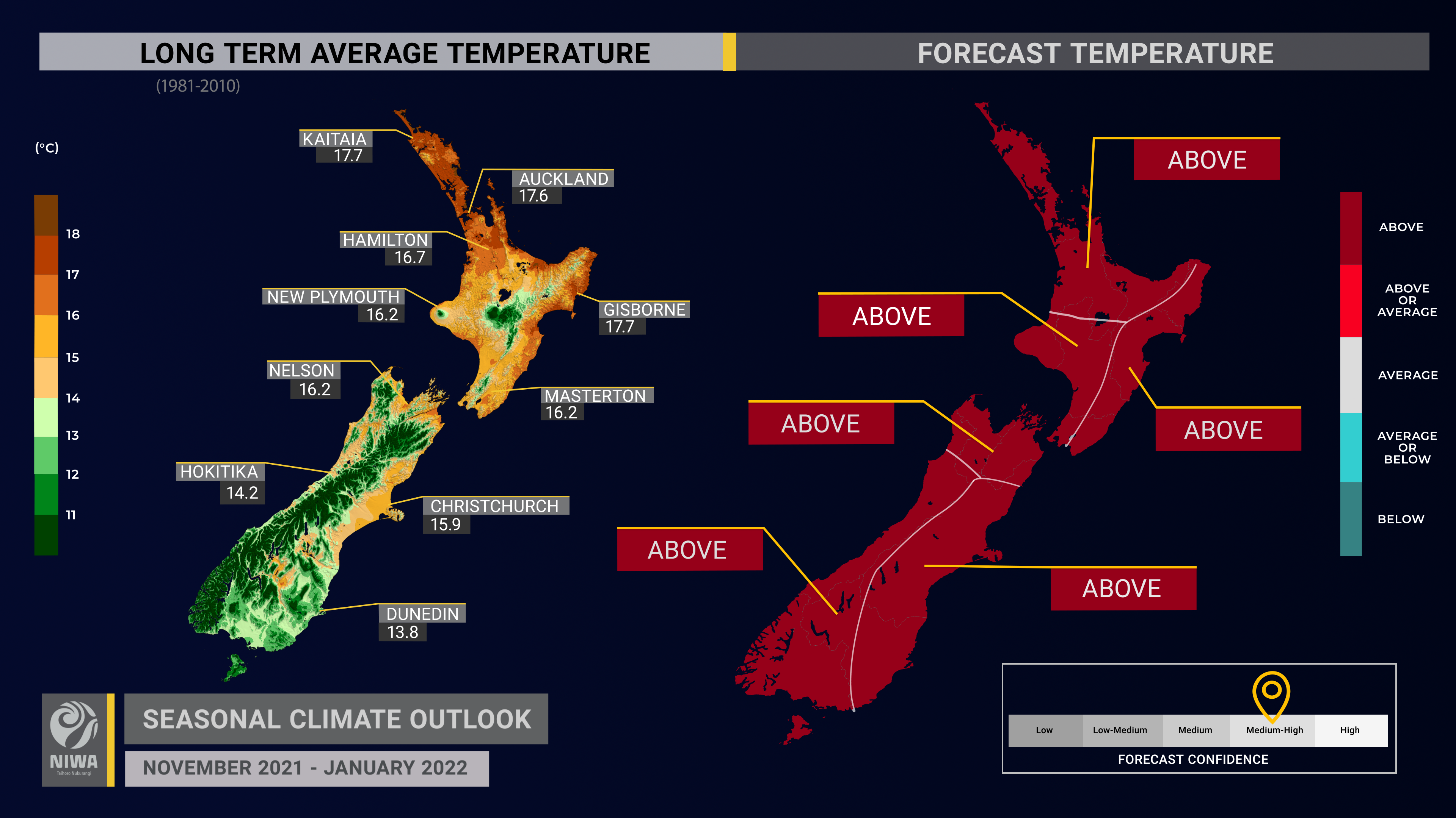
- Temperatures are very likely to be above average across Aotearoa New Zealand with a period of particularly warm conditions from around the second week of November.
- NZ’s coastal sea surface temperatures (SSTs) ranged from 0.5˚C to 1.0˚C above average during October. SSTs are predicted to become more unusually warm over the coming month or two which could culminate in marine heatwave conditions in some regions.
- Higher than normal air pressure is favoured over the South Island and to the south and east of the country, causing more easterly quarter winds and increasing the chance for dry spells in the South Island and western North Island in particular.
- For the tropical cyclone season (November 2021-April 2022), NIWA’s SW Pacific Tropical Cyclone Outlook indicates the risk for NZ is elevated. Those with marine interests north of the country should closely monitor the situation. On average, one tropical cyclone passes near the country each year, bringing heavy rain, strong winds, and rough seas.
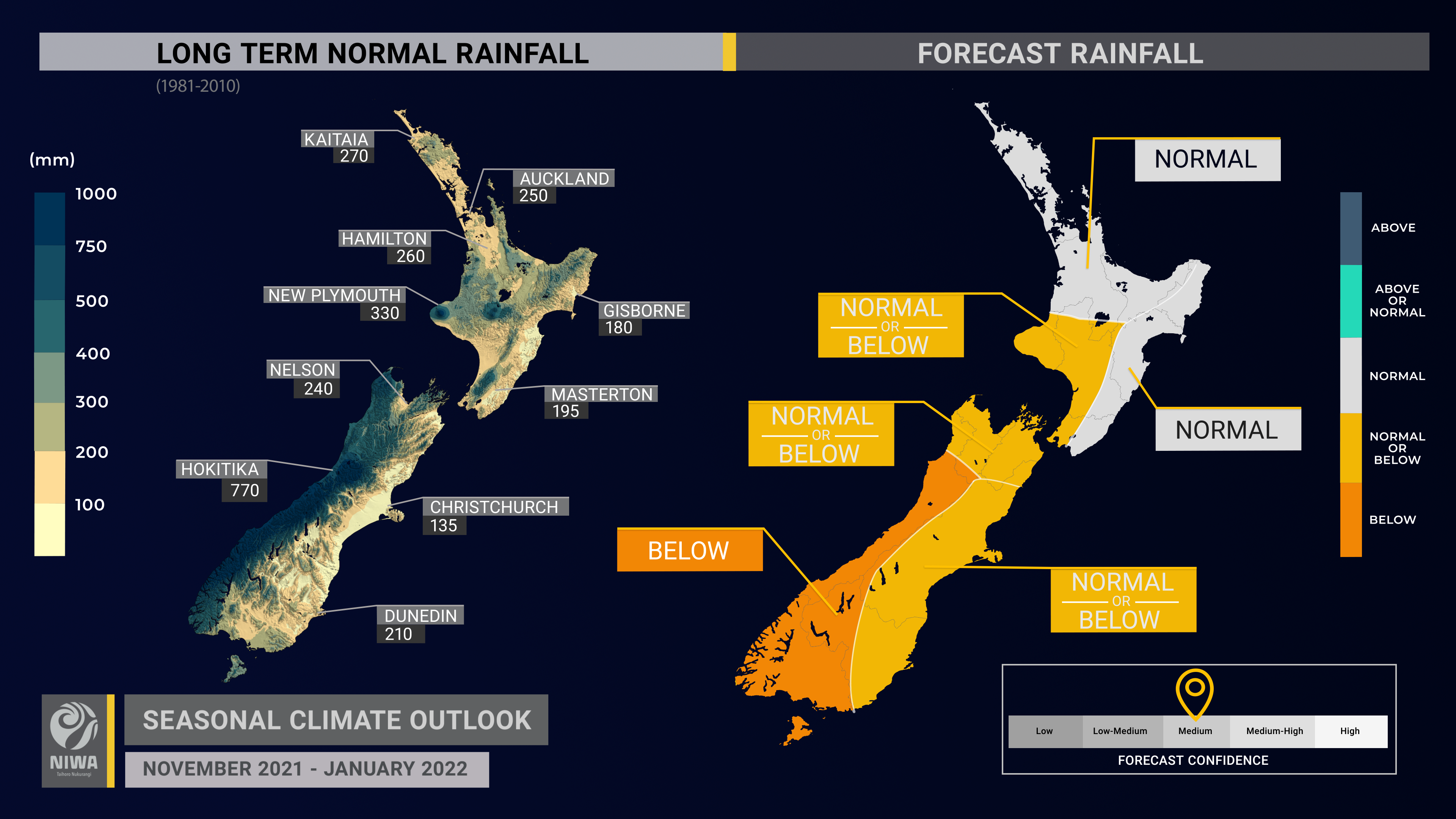
- Rainfall is most likely to be below normal in the west of the South Island, near normal in the north and east of the North Island and about equally likely to be near normal or below normal in all other regions. Occasional sub-tropical low pressure systems can bring heavy rainfall and possible flooding to NZ, particularly in the northern and eastern North Island.
- Soil moisture levels are most likely to be near normal in the east and west of the North Island and about equally likely to be near normal or below normal in all other regions.
- River flows are most likely to be near normal in the east of the North Island and about equally likely to be near normal or below normal in all other regions.
Regional predictions for November 2021 – January 2022
Northland, Auckland, Waikato, Bay of Plenty
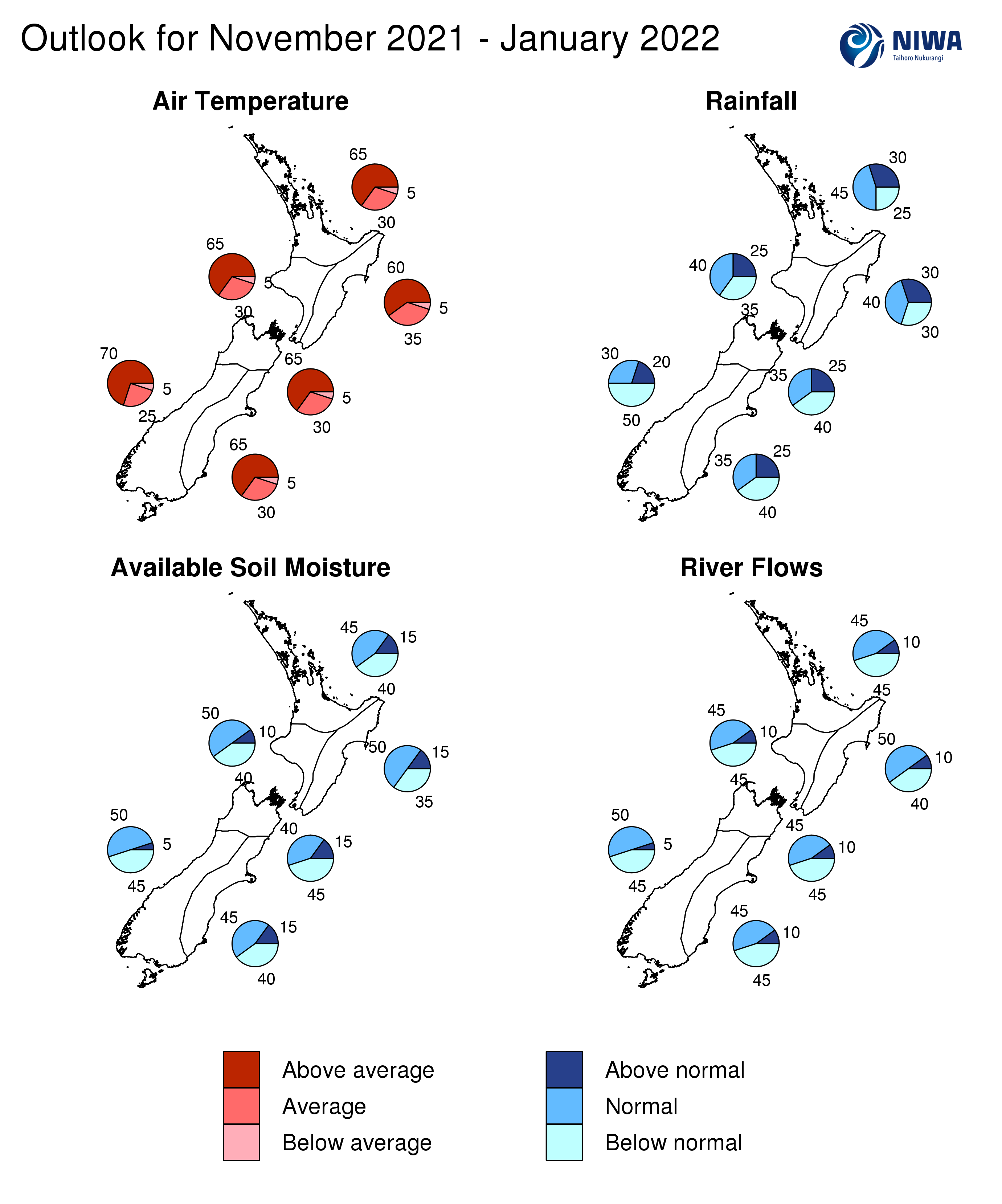
The table below shows the probabilities (or percent chances) for each of three categories: above average, near average, and below average. In the absence of any forecast guidance there would be an equal likelihood (33% chance) of the outcome being in any one of the three categories. Forecast information from local and global guidance models is used to indicate the deviation from equal chance expected for the coming three-month period, with the following outcomes the most likely (but not certain) for this region:
- Temperatures are very likely to be above average (65% chance).
- Rainfall totals are most likely to be near normal (45% chance).
- The potential for sub-tropical low pressure systems is elevated, particularly in the northern part of the region such as Northland. These systems can bring heavy rainfall and cause flooding. The risk is lower for southern and western parts of the region, like Waikato.
- Soil moisture and river flows are about equally likely to be near normal (45% chance) or below normal (40-45% chance).
The full probability breakdown is:
|
Temperature |
Rainfall |
Soil moisture |
River flows |
|
|
Above average |
65 |
30 |
15 |
10 |
|
Near average |
30 |
45 |
45 |
45 |
|
Below average |
05 |
25 |
40 |
45 |
Central North Island, Taranaki, Whanganui, Manawatu, Wellington
Probabilities are assigned in three categories: above average, near average, and below average.
- Temperatures are very likely to be above average (65% chance).
- Rainfall totals are about equally likely to be near normal (40% chance) or below normal (35% chance).
- Soil moisture levels are most likely to be near normal (50% chance) while river flows are equally likely to be near normal (45% chance) or below normal (45% chance).
The full probability breakdown is:
|
Temperature |
Rainfall |
Soil moisture |
River flows |
|
|
Above average |
65 |
25 |
10 |
10 |
|
Near average |
30 |
40 |
50 |
45 |
|
Below average |
05 |
35 |
40 |
45 |
Gisborne, Hawke’s Bay, Wairarapa
Probabilities are assigned in three categories: above average, near average, and below average.
- Temperatures are very likely to be above average (60% chance).
- Rainfall totals are most likely to be near normal (40% chance). Moist, humid easterly winds will increase the chance for periodic heavy rainfall across Gisborne and northern Hawke’s Bay, although chances are lower in southern areas like the Wairarapa. This may result in a south-to-north rainfall gradient across the region.
- Soil moisture and river flows are most likely to be near normal (50% chance).
The full probability breakdown is:
|
Temperature |
Rainfall |
Soil moisture |
River flows |
|
|
Above average |
60 |
30 |
15 |
10 |
|
Near average |
35 |
40 |
50 |
50 |
|
Below average |
05 |
30 |
35 |
40 |
Tasman, Nelson, Marlborough, Buller
Probabilities are assigned in three categories: above average, near average, and below average.
- Temperatures are very likely to be above average (65% chance).
- Rainfall totals are about equally likely to be below normal (40% chance) or near normal (35% chance).
- Soil moisture and river flows are about equally likely to be below normal (45% chance) or near normal (40-45% chance).
The full probability breakdown is:
|
Temperature |
Rainfall |
Soil moisture |
River flows |
|
|
Above average |
65 |
25 |
15 |
10 |
|
Near average |
30 |
35 |
40 |
45 |
|
Below average |
05 |
40 |
45 |
45 |
West Coast, Alps and foothills, inland Otago, Southland
Probabilities are assigned in three categories: above average, near average, and below average.
- Temperatures are very likely to be above average (70% chance).
- Rainfall totals are about most likely to be below normal (50% chance).
- The development of La Niña-like patterns may contribute to drier conditions in the coming months around the hydro lake areas.
- Soil moisture and river flows are about equally likely to be near normal (50% chance) or below normal (45% chance).
The full probability breakdown is:
|
Temperature |
Rainfall |
Soil moisture |
River flows |
|
|
Above average |
70 |
20 |
05 |
05 |
|
Near average |
25 |
30 |
50 |
50 |
|
Below average |
05 |
50 |
45 |
45 |
Coastal Canterbury, east Otago
Probabilities are assigned in three categories: above average, near average, and below average.
- Temperatures are very likely to be above average (65% chance).
- Rainfall totals are about equally likely to be below normal (40% chance) or near normal (35% chance).
- Soil moisture and river flows are about equally likely to be near normal (45% chance) or below normal (40-45% chance).
The full probability breakdown is:
|
Temperature |
Rainfall |
Soil moisture |
River flows |
|
|
Above average |
65 |
25 |
15 |
10 |
|
Near average |
30 |
35 |
45 |
45 |
|
Below average |
05 |
40 |
40 |
45 |
Graphical representation of the regional probabilities
Background
The NINO3.4 Index anomaly (in the central Pacific) during October (through the 24th) was -0.54˚C. The Southern Oscillation Index (SOI) was +0.8 during October, on the La Niña side of neutral. The three-month average SOI was +0.7, also on the La Niña side of neutral.
During October, upper-oceanic heat content decreased substantially across the equatorial Pacific. Sub-surface ocean conditions during October were 3˚C to 4˚C colder than average around 100 m depth in the east-central Pacific, a marked trend from September.
This was driven by an upwelling Kelvin wave and stronger than normal trade winds across the equatorial Pacific Ocean, focused over the Niño 3.4 region. Stronger than normal trade winds are expected to continue during November, which will result in continued cooling of the sea surface in the equatorial Pacific.
A negative Indian Ocean Dipole, referring to well-above average SSTs in the tropical eastern Indian Ocean, continued during October. The Pacific Decadal Oscillation also continued in its negative phase. These two climate drivers are commonly associated with La Niña conditions.
In stride with the oceanic trends over the past month as described above, NIWA has moved to “La Niña Alert”. There is an 80% chance for the development of a formal La Niña event between November-January, based on international guidance.
During October, convective forcing focused over Maritime Continent, eastern Indian Ocean, and western Pacific. This was influenced by the active phase of the Madden-Julian Oscillation (MJO) superimposed on the low frequency state associated with La Niña. The MJO was moving across the Americas and Africa during late October with a forecast for a pulse of the MJO to develop in the in the eastern Indian Ocean and Maritime Continent during the second week of November.
Importantly, this pulse of the MJO will become superimposed with La Niña’s low frequency forcing state. This process should result in a classical flavour of La Niña developing on a regional scale, including for New Zealand.
This is reflective of MJO phase 4, which has historically been warmer and drier than normal for much of the country during November. A weak expression of phases 5 through 7 may be possible from mid-to-late November, which tends to be wetter in the North Island.
By early December, a signal for convective forcing emerges in the Americas, Africa, and western Indian Ocean (phases 8 through 2), which tend to be warmer than average and drier than normal in the northern and eastern South Island and western North Island.
The Southern Annular Mode (SAM) was variable for the first half of October before trending toward positive values. A strong ridge of high pressure is forecast to develop in the New Zealand region during the first week of November with a likely continuation of a positive SAM.
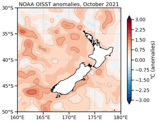
New Zealand’s coastal water temperatures were warmer than average during October, ranging from 0.5˚C to 1.0˚C above average. Anomalies decreased slightly compared to September, but are expected to increase in the next month or two. This is expected to have an upward influence on air temperatures around the start of summer.
NZ coastal SST anomalies (through 27 October)
|
North NI |
0.55˚C |
|
West NI |
0.58˚C |
|
East NI |
0.49˚C |
|
North SI |
0.67˚C |
|
West SI |
0.83˚C |
|
East SI |
0.96˚C |
Forecast Confidence
Temperature
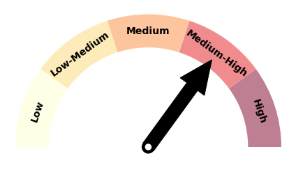
|
Forecast confidence for temperatures is medium to high, an increase compared to last month. Model guidance is in strong agreement on a warmer than average three month period, bolstered by a month of November that is looking unusually warm. NZ coastal sea temperatures are expected to become more abnormally warm heading into summer, which can help to reinforce the warmth. A tendency for more northeasterly winds will also elevate the chance for above average seasonal temperatures. |
Rainfall
|
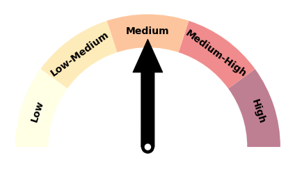
|
Forecast confidence for rainfall is medium, an increase compared to last month. Strong progress toward La Niña in the last month will likely enhance sub-seasonal to seasonal model forecast accuracy. The behaviour of the La Niña event has so far been more traditional for New Zealand, different from the same time period last year. There is multi-model agreement on high pressure systems occurring more frequently near, south, and east of the South Island, which is expected to increase the chance for drier patterns. |
