Outlook Summary
- La Niña conditions developed in the equatorial Pacific during November. Although this La Niña is unlikely to be strong, it is expected to be a key climate driver for Aotearoa New Zealand this summer. For more information, see the Background.
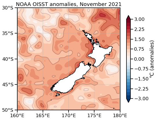
- Marine heatwave conditions were observed in New Zealand’s coastal waters during November. NZ’s coastal sea surface temperatures ranged from 1.1˚C to 1.5˚C above average. Unusually warm seas are expected to continue through summer, similar to 2017-18.
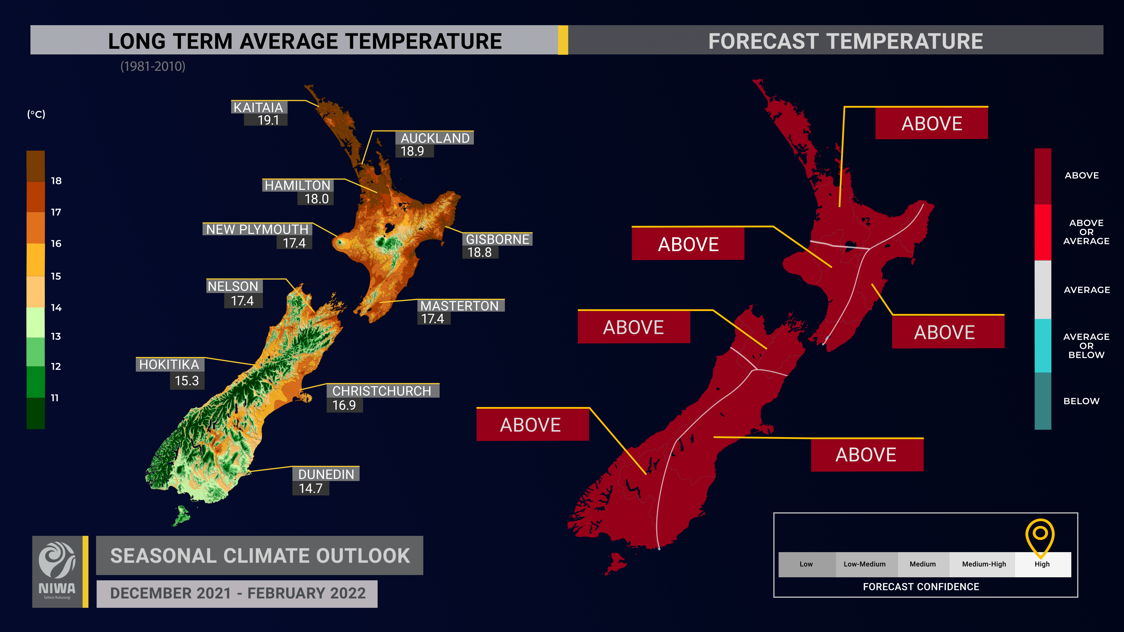
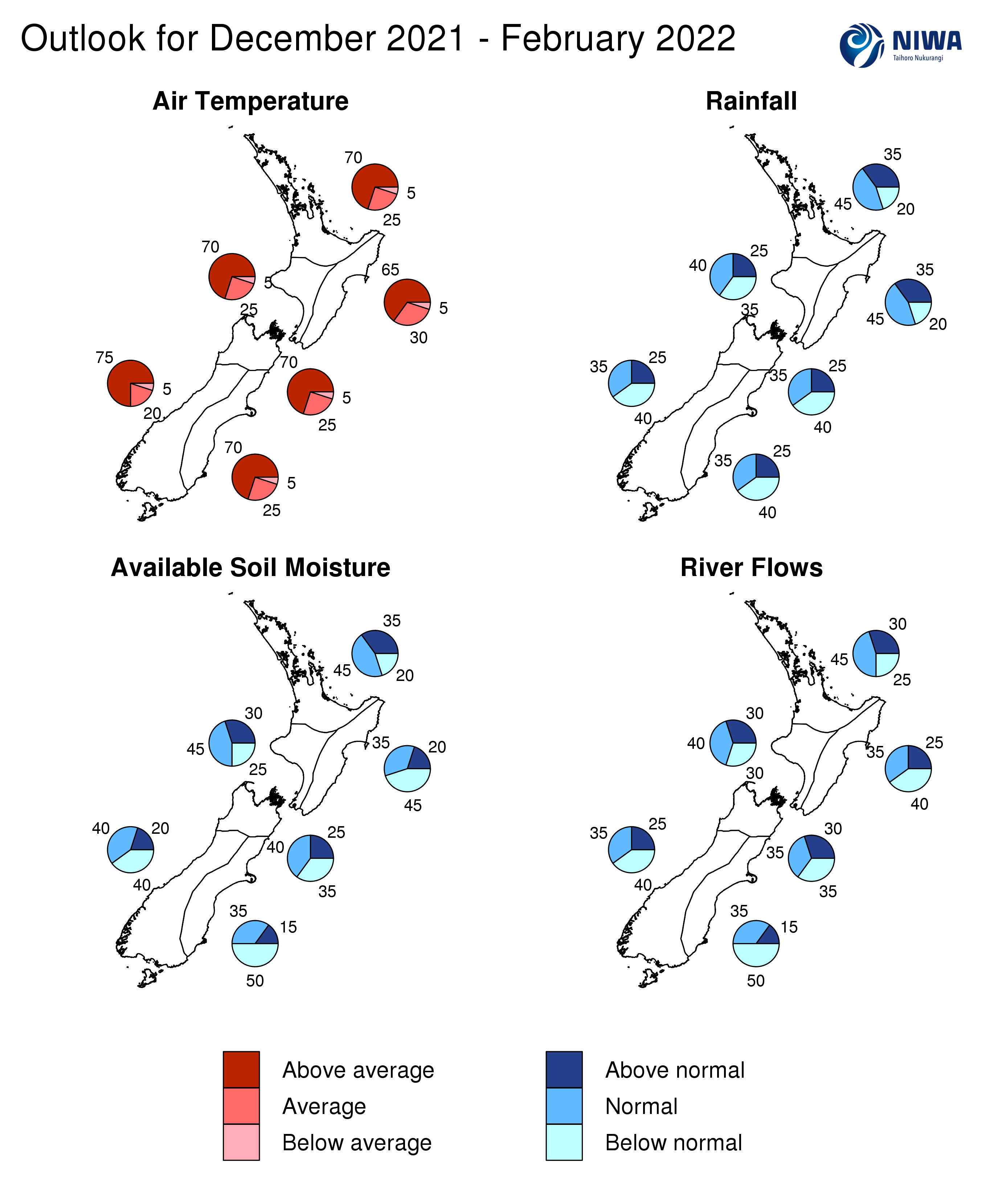
- Summer temperatures are very likely to be above average across the country. Warm overnight temperatures and extended periods of high humidity are likely.
- Air pressure is forecast to be higher than normal near, south, and east of the South Island. Lower than normal air pressure may develop north of the country, particularly later in the season. This is expected to be associated with more easterly quarter winds than normal, which increases the chance for dry spells about the interior and west of both islands.
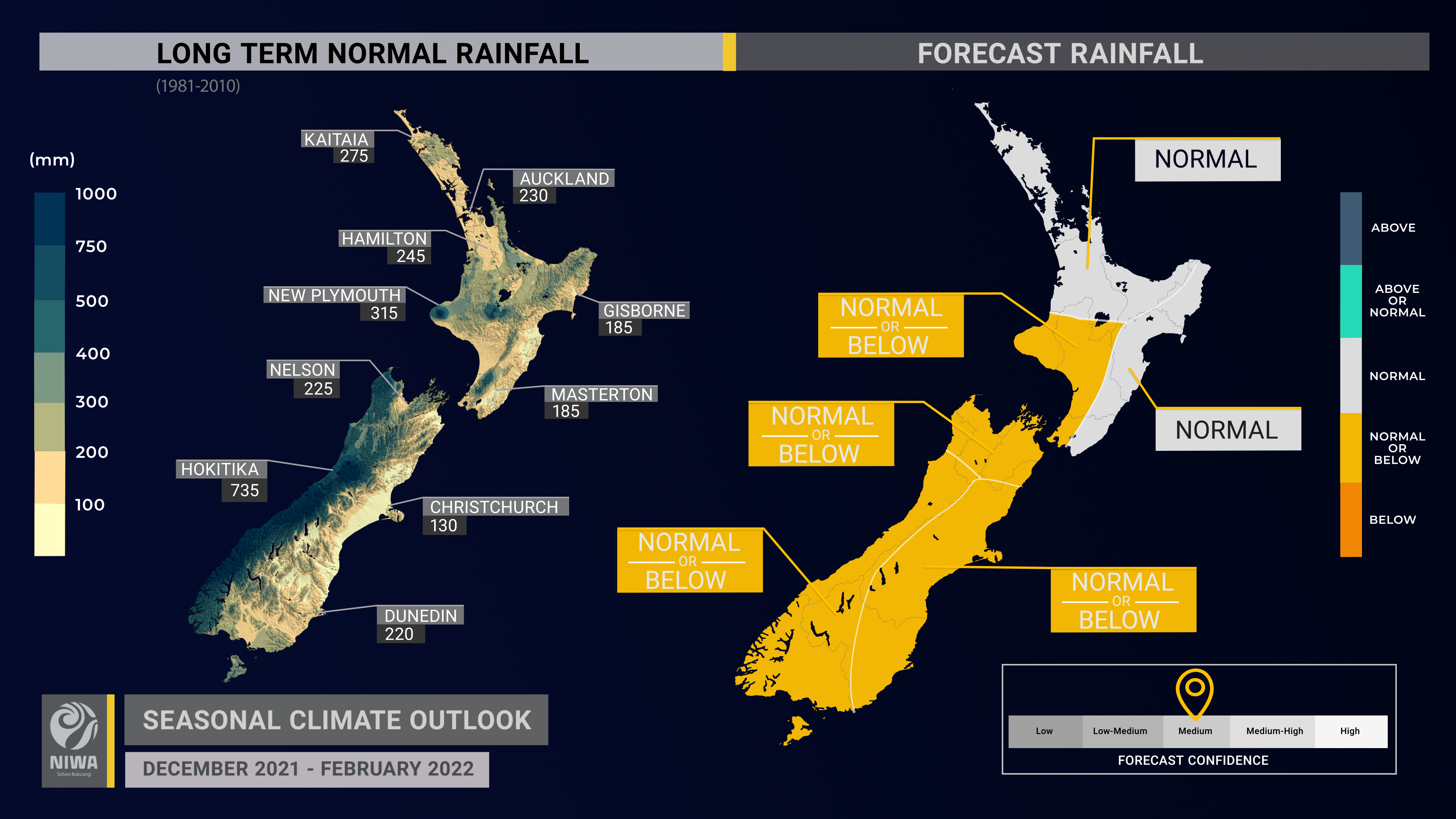
- Rainfall is most likely to be near normal in the north and east of the North Island and about equally likely to be near normal or below normal in all other regions. Occasional sub-tropical low pressure systems could bring heavy rainfall and possible flooding to New Zealand, particularly in the northern and eastern North Island.
- On average, one tropical cyclone passes near the country each year, bringing heavy rain, strong winds, and rough seas. For the tropical cyclone season (November 2021-April 2022), NIWA’s SW Pacific Tropical Cyclone Outlook indicates the risk for New Zealand is elevated. Those with marine interests north of the country should closely monitor the situation.
- Soil moisture levels are most likely to be below normal in the east of the North and South islands, near normal in the north and west of the North Island, and about equally likely to be near normal or below normal in all other regions.
- River flows are most likely to be below normal in the east of the South Island, near normal in the north and west of the North Island, and about equally likely to be near normal or below normal in the east of the North Island and west of the South Island. No clear guidance was available for the north of the South Island.
Regional predictions for December 2021 – February 2022
Northland, Auckland, Waikato, Bay of Plenty
The table below shows the probabilities (or percent chances) for each of three categories: above average, near average, and below average. In the absence of any forecast guidance there would be an equal likelihood (33% chance) of the outcome being in any one of the three categories. Forecast information from local and global guidance models is used to indicate the deviation from equal chance expected for the coming three-month period, with the following outcomes the most likely (but not certain) for this region:
- Temperatures are very likely to be above average (70% chance). Due to warmer than average coastal sea temperatures, higher humidity, and elevated overnight temperatures are likely.
- Rainfall totals are most likely to be near normal (45% chance) overall, but there may be substantial variability across the region.
- The potential for sub-tropical low pressure systems is elevated, particularly in the northern part of the region such as Northland. These systems can bring heavy rainfall and cause flooding. The risk is lower for southern and western parts of the region, like Waikato.
- Soil moisture levels and river flows are most likely to be near normal (45% chance).
The full probability breakdown is:
|
Temperature |
Rainfall |
Soil moisture |
River flows |
|
|
Above average |
70 |
35 |
35 |
30 |
|
Near average |
25 |
45 |
45 |
45 |
|
Below average |
05 |
20 |
20 |
25 |
Central North Island, Taranaki, Whanganui, Manawatu, Wellington
Probabilities are assigned in three categories: above average, near average, and below average.
- Temperatures are very likely to be above average (70% chance). Overnight temperatures are likely to be elevated due to warm coastal sea temperatures and higher humidity.
- Rainfall totals are about equally likely to be near normal (40% chance) or below normal (35% chance).
- Soil moisture levels and river flows are most likely to be near normal (40-45% chance).
The full probability breakdown is:
|
Temperature |
Rainfall |
Soil moisture |
River flows |
|
|
Above average |
70 |
25 |
30 |
30 |
|
Near average |
25 |
40 |
45 |
40 |
|
Below average |
05 |
35 |
25 |
30 |
Gisborne, Hawke’s Bay, Wairarapa
Probabilities are assigned in three categories: above average, near average, and below average.
- Temperatures are very likely to be above average (65% chance). Due to warmer than average coastal sea temperatures, higher humidity and elevated overnight temperatures are likely.
- Rainfall totals are most likely to be near normal (45% chance). Moist easterly winds will increase the chance for periodic heavy rainfall across Gisborne and northern Hawke’s Bay, although chances are lower in southern areas like the Wairarapa. This may result in a south-to-north rainfall gradient across the region.
- According to NIWA’s New Zealand Drought Index, Wairarapa was experiencing unusually dry conditions at the end of November.
- Soil moisture levels are most likely to be below normal (45% chance) while river flows are about equally likely to be near normal or below normal (35-40% chance).
The full probability breakdown is:
|
Temperature |
Rainfall |
Soil moisture |
River flows |
|
|
Above average |
65 |
35 |
20 |
25 |
|
Near average |
30 |
45 |
35 |
35 |
|
Below average |
05 |
20 |
45 |
40 |
Tasman, Nelson, Marlborough, Buller
Probabilities are assigned in three categories: above average, near average, and below average.
- Temperatures are very likely to be above average (70% chance).
- Rainfall totals are about equally likely to be below normal (40% chance) or near normal (35% chance).
- Soil moisture levels are about equally likely to be near normal (40% chance) or below normal (35% chance) while no clear guidance was available for river flows.
The full probability breakdown is:
|
Temperature |
Rainfall |
Soil moisture |
River flows |
|
|
Above average |
70 |
25 |
25 |
30 |
|
Near average |
25 |
35 |
40 |
35 |
|
Below average |
05 |
40 |
35 |
35 |
West Coast, Alps and foothills, inland Otago, Southland
Probabilities are assigned in three categories: above average, near average, and below average.
- Temperatures are very likely to be above average (75% chance).
- Rainfall totals are about equally likely to be below normal (40% chance) or near normal (35% chance).
- Along the West Coast, occasional heavy rainfall events may result from atmospheric rivers of moisture moving into the region.
- La Niña-like patterns of high pressure near the South Island may contribute to drier conditions around the hydro lake areas.
- Soil moisture levels and river flows are about equally likely to be near normal (35-40% chance) or below normal (40% chance).
The full probability breakdown is:
|
Temperature |
Rainfall |
Soil moisture |
River flows |
|
|
Above average |
75 |
25 |
20 |
25 |
|
Near average |
20 |
35 |
40 |
35 |
|
Below average |
05 |
40 |
40 |
40 |
Coastal Canterbury, east Otago
Probabilities are assigned in three categories: above average, near average, and below average.
- Temperatures are very likely to be above average (70% chance). More easterly quarter winds than normal may keep overnight temperatures elevated.
- Rainfall totals are about equally likely to be below normal (40% chance) or near normal (35% chance).
- According to NIWA’s New Zealand Drought Index, mid-Canterbury and Banks Peninsula were experiencing unusually dry conditions at the end of November.
- Soil moisture levels and river flows are most likely to be below normal (50% chance).
The full probability breakdown is:
|
Temperature |
Rainfall |
Soil moisture |
River flows |
|
|
Above average |
70 |
25 |
15 |
15 |
|
Near average |
25 |
35 |
35 |
35 |
|
Below average |
05 |
40 |
50 |
50 |
Graphical representation of the regional probabilities
Background
The NINO3.4 Index anomaly (in the central Pacific) during November (through the 28th) was -0.59˚C and the Southern Oscillation Index (SOI) was +1.1, both near the La Niña threshold. The three-month average SOI was +0.9.
Upper-oceanic heat content was well below normal in the central and eastern equatorial Pacific during November as a full-basin La Niña signature matured. Modest cool anomalies persisted in the sub-surface, although the coolest water relative to normal has now surfaced or is surfacing. From an oceanic perspective, La Niña will likely peak over the next month.
The Pacific Decadal Oscillation also continued in a strongly negative phase, which is more common during La Niña events. The Southwest Pacific Convergence Zone was displaced southwest of its climatological position, again consistent with La Niña.
Convective forcing was focused over Africa, the eastern Indian Ocean, Maritime Continent, and far western Pacific during November, indicative of the atmospheric response to La Niña.
In addition to the oceanic and atmospheric trends described above, New Zealand’s local weather patterns have been consistent with La Niña, with more northeasterly winds than normal through spring. Therefore, NIWA has classified a La Niña event, with an 85% chance of it continuing through the summer season.
Looking ahead, climate patterns will be influenced by the active phase of the Madden-Julian Oscillation (MJO) in phases 6 and 7 during the first half of December before its emergence over the Americas and Africa during the second half of the month (phases 8 and 1). These phases have historically been associated with warmer than average temperatures across New Zealand. Rainfall during the same phases has been mixed, although a tendency for dryness is noted in the eastern South Island (phases 6 and 7) with wetter conditions in the north and east of the North Island (phase 7).
The Southern Annular Mode (SAM) was strongly positive for the duration of November. With higher than normal air pressure forecast to continue in the New Zealand region, the SAM is favoured to remain positive through much of December. This supports a warmer than average end to the year across the country, with southerly fronts occurring infrequently.
Marine heatwave conditions became established in New Zealand’s coastal waters during the second half of November. Temperature anomalies ranged from +1.1˚C to +1.5˚C for the month as a whole, although daily anomalies reached in excess of +3.0˚C around the western and northern North Island. Climate models indicate that unusually warm seas will continue to be a factor this summer, with the potential for marine heatwave conditions during December and January in particular. This is expected to have a strong upward influence on air temperatures and humidity and may provide more moisture for weather systems to tap into as they approach the country. Those with interests in New Zealand’s marine environment should remain alert of the latest updates through the season.
NZ coastal SST anomalies (through 29 November)
|
North NI |
1.43˚C |
|
West NI |
1.49˚C |
|
East NI |
1.10˚C |
|
North SI |
1.21˚C |
|
West SI |
1.39˚C |
|
East SI |
1.25˚C |
Forecast Confidence
Temperature
|
Forecast confidence for temperatures is high. This level of confidence is being influenced by marine heatwave conditions in New Zealand’s coastal waters, comparable to this time in 2017. La Niña will likely influence more northeasterly winds in the coming months and the tendency for a positive SAM will likely limit the frequency of southerly fronts. The climate models maintain a confident outlook on warmer than average temperatures – in fact, all of the climate models that NIWA surveys indicate a warmer than average December-February. |
Rainfall
|
Forecast confidence for rainfall is medium. The existence of traditional La Niña conditions, as a key climate driver, should help with predictability. There is multi-model agreement on the likelihood of high pressure systems hovering near the South Island, which is expected to increase the chance for drier patterns. Although the model guidance is in relatively good agreement that a drier than normal summer is unlikely in the north and east of the North Island, caution is advised following the outcomes of the last two summers. |
