Heavy downpours and unseasonable warmth
|
Rainfall |
Large areas of well above normal rainfall (>149% of normal) were observed over Marlborough, Nelson, Tasman, West Coast, Canterbury High Country and inland Otago. Patches of above normal rainfall (120-149% of normal) were seen in coastal northern Northland, inland Bay of Plenty, Wellington and the Kāpiti Coast. Below normal rainfall (50-79% of normal) was observed for western Northland, Auckland, much of Waikato, coastal Taranaki, coastal Manawatū-Whanganui, much of the Wairarapa, parts of the upper and lower Canterbury plains, and southern Otago. Well below normal rainfall (<50% of normal) was seen for the eastern North Island extending from Gisborne to the eastern Wairarapa hills, as well as coastal Canterbury from Selwyn to Kaikōura. |
|
Temperature |
Temperatures were above average (0.51-1.20°C above average) or well above average (>1.20°C above average) for most of the country. The exception was in parts of Auckland, Bay of Plenty, parts of Waikato, inland parts of Manawatū-Whanganui, northern Hawke’s Bay, Nelson, as well as patches along the eastern coastal fringe of the South Island, where near average temperatures (±0.50°C of average) were observed. |
|
Soil Moisture |
At the end of July, soil moisture levels were near normal for most of New Zealand. The only region of lower than normal soil moisture was an area extending from Central Hawke’s Bay into the Tararua district. |
Overview
Although July started with a ridge of high pressure, this quickly abated and the month became defined by mobile weather systems and fronts. These fronts frequently drew sub-tropical moisture and warmth from the lower latitudes in northerly-component airstreams, resulting in bursts of heavy rain to the western South Island and rain and thunderstorms to the North Island. The stand-out rain event occurred between 15-18 July and brought over 690 mm of rain to parts of the West Coast in under 72 hours. The Buller River swelled in response to the rain, and flood flows on the Buller River were the largest of any river in Aotearoa New Zealand in almost 100 years.
The variability in weather systems was also reflected in the Southern Annual Mode (SAM), which transitioned from positive to negative at the beginning of July, in contrast to June where it remained largely positive. The phase and magnitude of the SAM is a proxy for the strength and position of the belt of westerly winds that span zonally across the Southern Ocean. In its negative phase, the SAM usually results in lower than normal air pressure around New Zealand, reflecting the increased risk for unsettled weather conditions.
Additionally, the Bureau of Meteorology in Australia (BOM) declared a negative Indian Ocean Dipole (IOD) event was underway during July, which may have allowed for more tropical moisture to become available to passing weather systems.
Finally, convective forcing due to the Madden-Julian Oscillation (MJO) was active over Africa and the Indian Ocean early in the month before moving into the western Pacific. In association with this, several plumes of deep, tropical moisture stretched from the eastern Indian Ocean to New Zealand, including one that caused extreme flooding in the Buller District. This likely also had some connection to the IOD event.
There were significant spatial differences in the observed rainfall over the country in July. Large areas of well above normal rainfall (>149% of normal) were observed over Marlborough, Nelson, Tasman, West Coast, Canterbury high country and northern Otago. Patches of above normal rainfall (120-149% of normal) were seen in coastal northern Northland, inland Bay of Plenty and around Wellington central and the Kāpiti Coast. Near normal rainfall (80-119% of normal) was observed across eastern Northland, inland Taranaki, inland Manawatū, inland Waikato, Bay of Plenty and up to East Cape, as well as parts of Southland and the foothills of the Canterbury and eastern Marlborough ranges. Below normal rainfall (50-79% of normal) was observed for western Northland, Auckland, much of Waikato, coastal Taranaki, coastal Manawatū-Whanganui, much of the Wairarapa, parts of the upper and lower Canterbury plains, and southern Otago. Well below normal rainfall (<50% of normal) was seen for the eastern North Island extending from Gisborne to the eastern Wairarapa hills, as well as coastal Canterbury from Akaroa to Kaikōura.
Near average temperatures (±0.50°C of average) were observed for parts of Auckland, Bay of Plenty, parts of Waikato, inland parts of Manawatū-Whanganui, northern Hawke’s Bay, Nelson, as well as patches along the eastern coastal fringe of the South Island. Temperatures were above average (0.51-1.20°C above average) or well above average (>1.20°C above average) for the remainder of New Zealand.
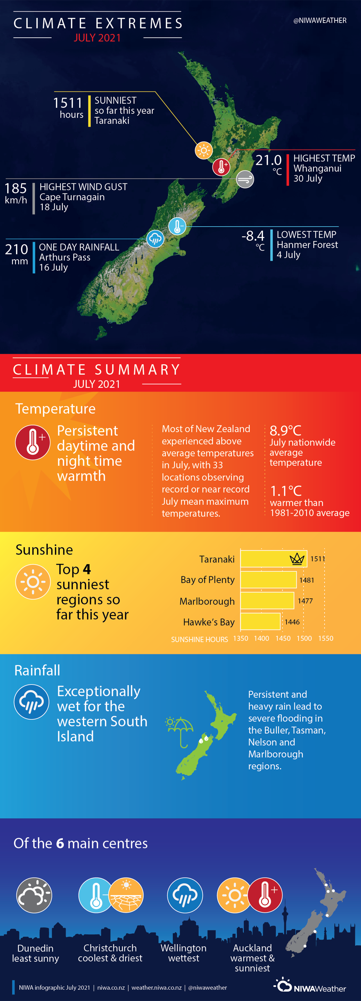
July 2021 was the 6th-equal warmest July on record. Six out the seven warmest Julys on record have occurred since the year 2000. The mean temperature for July 2021 was 8.9°C which is 1.1°C warmer than average (1981-2010).
Further Highlights:
- The highest temperature was 21.0°C, observed at Whanganui on 30 July.
- The lowest temperature was -8.4°C, observed at Hanmer Forest on 4 July.
- The highest 1-day rainfall was 210 mm, recorded at Arthurs Pass on 16 July.
- The highest wind gust was 185 km/h, observed at Cape Turnagain on 18 July.
- Of the six main centres in July 2021, Auckland was the warmest and sunniest, Wellington was the wettest, Christchurch was the driest and coolest, and Dunedin was the least sunny.
- Of the available, regularly reporting sunshine observation sites, the sunniest four locations so far in 2021 are Taranaki (1511 hours), Bay of Plenty (1481 hours), Marlborough (1477 hours), and Hawke’s Bay (1446 hours)
Download
- Climate Summary July 2021 [PDF 630.87 KB]
- Climate Statistics July 2021