Variable rainfall patterns; cool in the lower South Island
|
Temperature |
Temperatures were near average (-0.50 to +0.50°C of average) across nearly the entire North Island, as well as much of the northern South Island and the West Coast. Isolated above average temperatures (0.51°C to 1.2°C above average) were observed in Northland, the Coromandel Peninsula, Taranaki, Hawke’s Bay, and northern Tasman. Meanwhile, widespread below average temperatures (0.51°C to 1.2°C below average) and isolated well below average temperatures (<1.2°C below average) were observed from central Canterbury to Otago. |
|
Rainfall |
Rainfall was above normal (120% to 149% of normal) or well above normal (>149% of normal) for many east-facing coastal areas, including Northland, the Coromandel Peninsula, Gisborne, Hawke’s Bay, southern Canterbury, Otago, and Southland. Conversely, below normal rainfall (50% to 79% of normal) was observed in western Northland, parts of Auckland and Waikato, the Central Plateau, and Marlborough. Elsewhere, generally near normal rainfall (80% to 119% of normal) was observed. |
|
Soil Moisture |
As of 1 November, soil moisture was near normal across most of New Zealand. Soils were wetter than normal in coastal Gisborne, much of Hawke’s Bay, as well as coastal Canterbury, Otago, and Southland. Meanwhile, drier than normal soils were observed in western Northland, Wairarapa, Marlborough, and southern Canterbury to interior Otago. |
Overview
October 2019 was characterised by lower than normal mean sea level pressure to the east of New Zealand. This pressure setup resulted in a southeast airflow anomaly across the country (i.e. more southeasterly winds than normal). This pattern was associated with the most negative monthly value (-0.9) of the Southern Annular Mode (SAM) since January 2017. In its negative phase, the SAM is associated with unsettled conditions and increased windiness in the New Zealand region.
Weather varied considerably depending on geographic location, with eastern areas generally experiencing wetter and cooler conditions due to the onshore wind flow. Conversely, western areas tended to be a bit drier and more settled. October was also a windy month, with several southerly changes moving up the country. Thirteen locations observed record or near-record extreme wind gusts during the month. High winds were at least partly responsible for a capsized vessel off Cape Brett, where one person died, and exacerbating a large fire in Auckland’s CBD (see Highlights and extreme events section for further details).
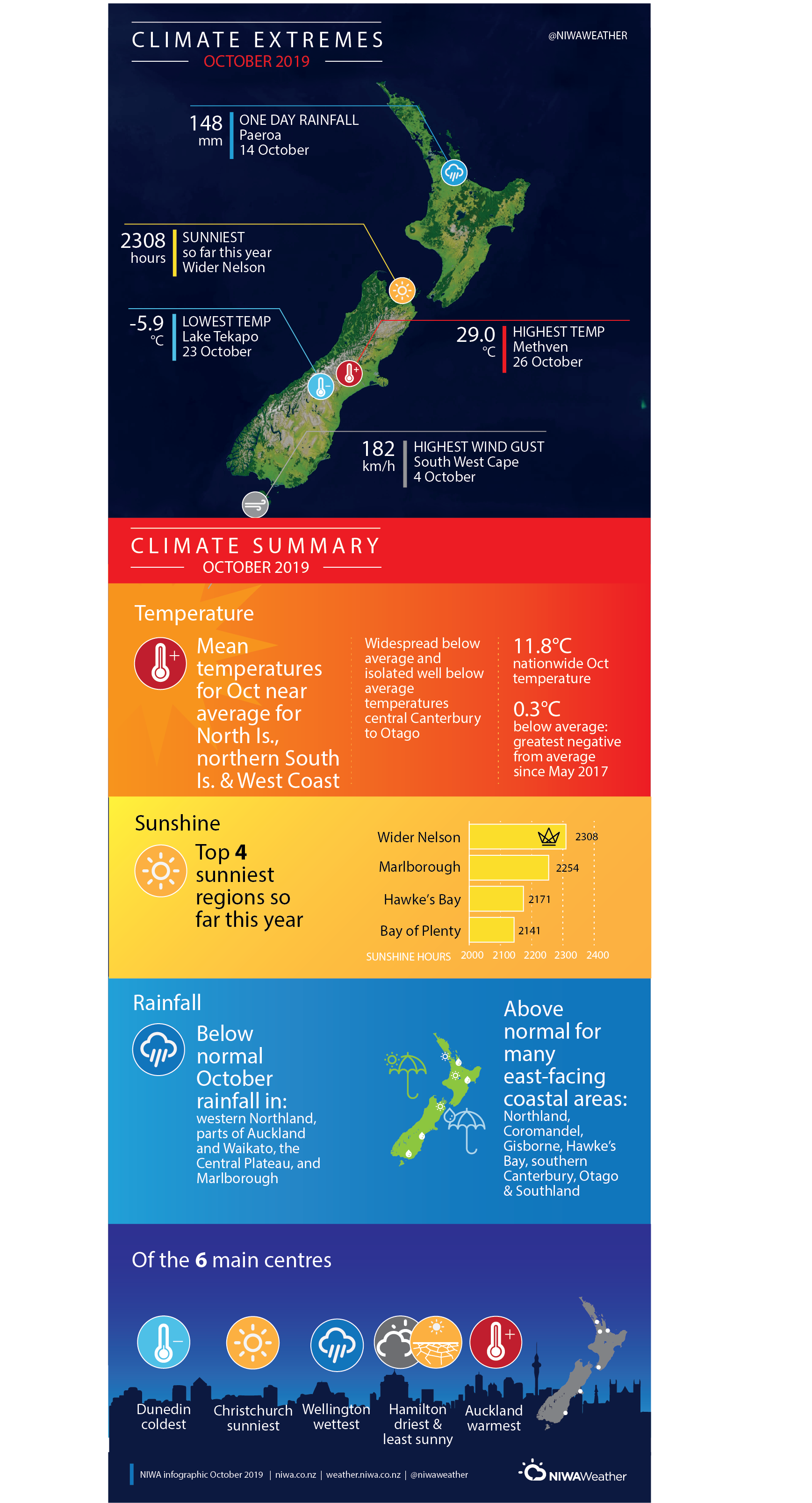
The nationwide average temperature in October 2019 was 11.8°C (0.3°C below the 1981-2010 October average from NIWA’s seven station temperature series which begins in 1909). The October 2019 temperature anomaly of -0.3˚C (i.e. on the cold side of average and officially classed as near average) is the greatest negative deviation from the 1981-2010 average of any month in the last two and a half years, since May 2017 which also had a -0.3˚C temperature anomaly. This is also the coldest October compared to average since October 2012, which also had a -0.3˚C temperature anomaly. In addition, September and October 2019 mark the first consecutive months to have temperature anomalies on the cold side of average since January and February 2017. It has now been 33 consecutive months since New Zealand experienced a nationwide average temperature that was officially below average (i.e. at least 0.51˚C below the 1981-2010 average).
October temperatures were near average (-0.50 to +0.50°C of average) across nearly the entire North Island, as well as much of the northern South Island and the West Coast. Isolated above average temperatures (0.51°C to 1.2°C above average) were observed in Northland, the Coromandel Peninsula, Taranaki, Hawke’s Bay, and northern Tasman. Meanwhile, widespread below average temperatures (0.51°C to 1.2°C below average) and isolated well below average temperatures (<1.2°C below average) were observed from central Canterbury to Otago.
October rainfall was above normal (120% to 149% of normal) or well above normal (>149% of normal) for many east-facing coastal areas, including Northland, the Coromandel Peninsula, Gisborne, Hawke’s Bay, southern Canterbury, Otago, and Southland. Conversely, below normal rainfall (50% to 79% of normal) was observed in western Northland, parts of Auckland and Waikato, the Central Plateau, and Marlborough. Elsewhere, generally near normal rainfall (80% to 119% of normal) was observed.
Further Highlights:
- The highest temperature was 29.0°C, observed at Methven on 26 October.
- The lowest temperature was -5.9°C, observed at Lake Tekapo on 23 October.
- The highest 1-day rainfall was 148 mm, recorded at Paeroa on 14 October.
- The highest wind gust was 182 km/h, observed at South West Cape on 4 October.
- Of the six main centres in October 2019, Auckland was the warmest, Dunedin was the coldest, Wellington was the wettest, Hamilton was the driest and least sunny, and Christchurch was the sunniest.
- Of the available, regularly reporting sunshine observation sites, the sunniest four regions in 2019 so far are Wider Nelson (2308 hours), Marlborough (2254 hours), Hawke’s Bay (2171 hours), and Bay of Plenty (2141 hours).