Heavy rain, flooding, and New Zealand’s 2nd-warmest August
|
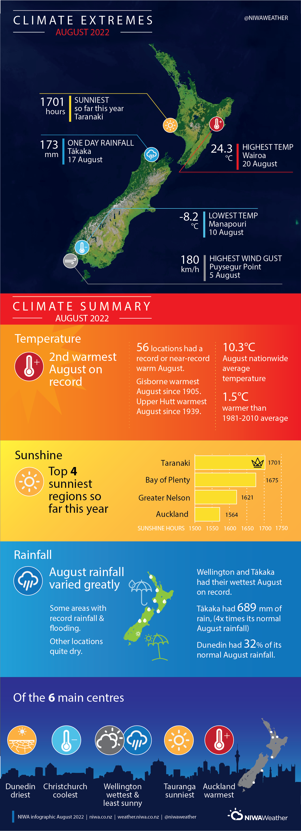
Temperature |
It was New Zealand’s 2nd-warmest August on record, with the nationwide average temperature 1.5°C above average. Well above average (>1.20°C above average) temperatures were observed in a majority of the North Island and the central South Island, and many locations experienced a record or near-record warm August. Above average temperatures (0.51-1.20°C above average) were observed in parts of Bay of Plenty, western Waikato, coastal South Canterbury, eastern Otago, and much of Southland. Isolated pockets of near average temperatures (±0.50°C of average) were observed in Tasman and Southland. |
|
Rainfall |
Rainfall varied greatly in August, with some areas experiencing record-setting rainfall and flooding, while other locations were quite dry. Well above normal (>149% of normal) or above normal (120-149% of normal) rainfall was observed in northern Northland, parts of Auckland, western Waikato and Taranaki, southern Hawke’s Bay, southern Manawatū-Whanganui to western Wellington, Tasman, Nelson, Marlborough, the West Coast, interior Canterbury, and northern Otago. Conversely, below normal rainfall (50-79% of normal) was observed in southern Northland, northern Waikato and the Coromandel, parts of Bay of Plenty and Gisborne, interior Manawatū-Whanganui, much of coastal Canterbury, southern Otago and eastern Southland. Pockets of well below normal rainfall (<50% of normal) occurred in eastern Bay of Plenty, Banks Peninsula, and near Dunedin. Elsewhere, near normal rainfall (80-119% of normal) was observed. |
|
Soil Moisture |
At the end of August, soil moisture levels were near normal for a majority of the country. Above normal soil moisture was observed in eastern Marlborough, coastal South Canterbury, and interior Otago. |
Overview
August 2022 was notable for extreme rainfall and flooding, and being Aotearoa New Zealand’s 2nd-warmest August on record. This was driven by the combined effect of La Niña conditions and a negative Indian Ocean Dipole, marked by warmer than average seas in the tropical eastern Indian Ocean near Sumatra and cooler seas in the western Indian Ocean near Africa, warm coastal sea temperatures and marine heatwave conditions in the New Zealand region, and a pulse of the Madden-Julian Oscillation in the Australasia region (an area of enhanced rain and cloud in the tropics). The resultant circulation pattern favoured a persistent blocking high pressure system to the east of the country and more northeasterly winds than normal.
The most impactful event was the mid-month atmospheric river and flooding event which occurred from 16-20 August. An incredibly moisture-rich plume of air from the tropics sat over parts of the country for five days, bringing extreme rainfall to places such as Nelson, Tasman, western Marlborough, Wellington, Taranaki, and parts of Northland. An analysis by NIWA indicated it was the strongest August atmospheric river on record since at least 1959, resulting in a 1-in-120 year rain event in Nelson. Nelson experienced severe flooding as the Maitai River burst its banks, and the river’s flow reached a maximum of 459 cumecs on 17 August, nearly double its previous record flow of 237 cumecs in December 2011. Numerous road closures occurred in the top of the South Island due to flooding and slips, most notably State Highway 6 between Hira and Havelock, severing the direct link between Nelson and Blenheim. In Taranaki, rivers rose rapidly on 18 August as extreme rainfall fell on Mt Taranaki, where more than a metre of rain was observed during the multi-day event. (see Highlights and extreme events section for more details).
While the atmospheric river event garnered the most headlines, it wasn’t the only notable heavy rainfall during August. On 5-6 August, heavy rain in interior Canterbury led to high flows and erosion in some rivers, including the Ashburton and Rangitata rivers, while Haast Pass was closed due to flooding. Another significant rainfall event was more localised in Wellington on 8 August, which led to road closures and home evacuations in the city.
August 2022 was New Zealand’s 2nd-warmest August on record (placing behind only August 2013), as well above average (>1.20°C above average) temperatures were observed in a majority of the North Island and the central South Island, and 56 locations experienced a record or near-record warm August. This included Gisborne having its warmest August since 1905, and Upper Hutt having its warmest August since 1939. The warmth was aided by a predominant northerly air flow during the month as high pressure was frequently stationed to the east of the country. It was a cloudy month in the upper and lower North Island and the top of the South Island, and this was reflected in warmer than usual overnight temperatures with many locations experiencing record or near-record high mean minimum (overnight) temperatures. The nights of the 19th and 20th August were particularly notable, as a northerly air flow directly out of the tropics led to numerous locations having their warmest August night on record. On 19 August, Kaitaia recorded a minimum temperature of 18.2˚C, the warmest August minimum temperature on record for all of New Zealand. Overall, the nationwide average temperature in August 2022 was 10.3°C. This was 1.5°C above the 1981-2010 August average, based on NIWA’s seven station temperature series which began in 1909.
Despite the very warm month overall, cold outbreaks typical of winter were still observed. On 7-8 August, substantial snowfall fell to relatively low elevations across interior Canterbury and Otago. At elevations of 500-600 metres, amounts of 5-10 cm were observed, including at locations such as Ranfurly, St Bathans, and Methven. In addition, on the 10th Invercargill recorded its 2nd-coldest August temperature since records began in 1905 with -6.4˚C, while Manapouri had its 2nd-coldest August temperature since 1963 with -8.2˚C.
Further highlights
- The highest temperature was 24.3°C, observed at Wairoa on 20 August.
- The lowest temperature was -8.2°C, observed at Manapouri on 10 August.
- The highest 1-day rainfall was 173 mm, recorded at Tākaka on 17 August.
- The highest wind gust was 180 km/h, observed at Puysegur Point on 5 August.
- Of the six main centres in August 2022, Auckland was the warmest, Christchurch was the coolest, Wellington was the wettest and least sunny, Dunedin was the driest, and Tauranga was the sunniest.
- Of the available, regularly reporting sunshine observation sites, the sunniest four regions in 2022 so far are Taranaki (1701 hours), Bay of Plenty (1675 hours), Greater Nelson (1621 hours) and Auckland (1564 hours).
Download
- August 2022 Climate Summary [PDF 1.6MB]
- Climate Statistics Report August 2022 [PDF 159 KB]
