A warm month, wet in the west but dry in the east
|
Temperature |
Temperatures were above average (0.51-1.20°C above average) or well above average (>1.20°C above average) for most of the country. Near average temperatures (±0.50°C of average) were observed in southeastern parts of the South Island. Tara Hills (near Omarama) was the only location where temperatures were below average (0.51-1.20°C below average). |
|
Rainfall |
Rainfall was above normal (120-149% of normal) or well above normal (>149% of normal) for many western and inland parts of New Zealand. Rainfall was below normal (50-79% of normal) or well below normal (<50% of normal) for eastern parts of the country, and western parts of Northland. |
|
Soil Moisture |
At the end of the month, soil moisture levels were significantly lower than normal for eastern-most parts of Otago and Canterbury. Soil moisture levels were higher than normal for inland parts of the South Island, especially inland Canterbury. Near normal soil moisture levels were typical for the remainder of the country. |
Overview
June 2022 mean sea level air pressure was lower than normal in the Aotearoa New Zealand region. The Tasman Sea and Southern Ocean was particularly unsettled with numerous strong low pressure systems and fronts, especially during the first half of the month. This was associated with a northwesterly air flow anomaly for the month overall. The prevalence of these air flows, and ongoing warmer than average sea surface temperatures, meant it was a warm start to winter for most of the country. The Southern Annular Mode (SAM), a proxy for the location of the polar jet stream and storm track, was in its negative phase for much of June, with the 30-day running average becoming negative for the first time since early September 2021 (In its negative phase, the SAM usually results in lower-than-normal air pressure and increased westerlies around New Zealand, increasing the risk for unsettled weather conditions).
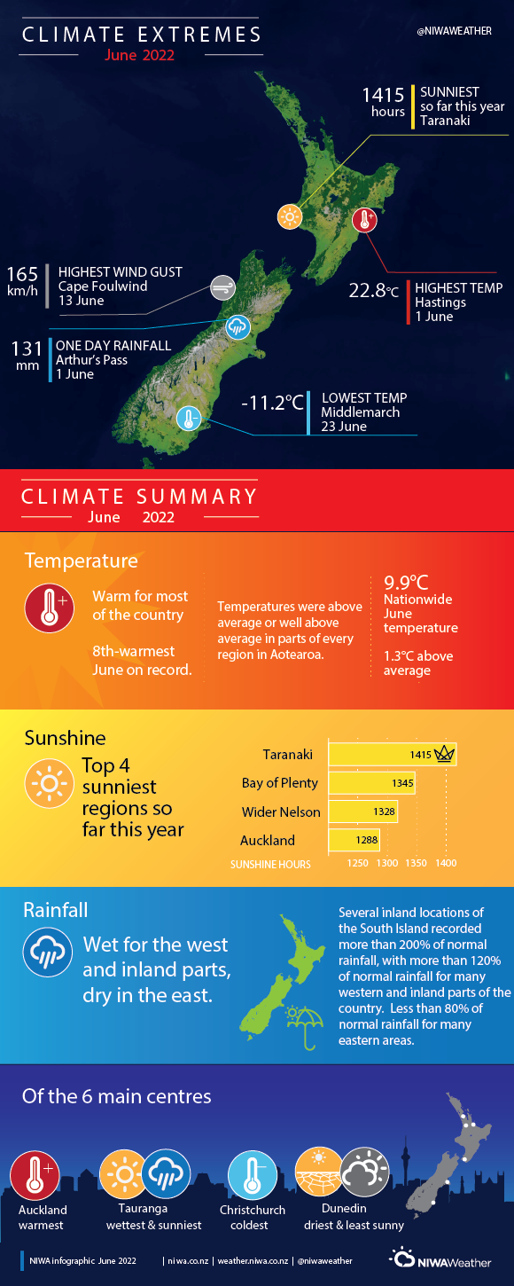
Temperatures were above average (0.51-1.20°C above average) or well above average (>1.20°C above average) in every region of New Zealand, with well above average temperatures prevailing over most of the North Island. The exception to this unseasonable warmth were parts of Southland and southeastern Otago, where temperatures were near normal (±0.50°C of average). In addition, Tara Hills (near Omarama) observed below average mean temperatures (0.51-1.20°C below average). The area received a heavy snowfall in mid-June, followed by a prolonged spell of cold days and nights associated with high atmospheric pressure (see Highlights and extreme events for further details). Overall, the nationwide average temperature in June 2022 was 9.9°C. This was 1.3°C above the 1981-2010 June average, making it New Zealand’s 8th-warmest June since NIWA’s seven station temperature series began in 1909.
Rainfall was above normal (120-149% of normal) or well above normal (>149% of normal) for many western and inland parts of New Zealand. It was especially wet in inland parts of Otago and Canterbury, and Tauranga, where rainfall totals observed were approximately double the June average, respectively. In contrast, rainfall was below normal (50-79% of normal) or well below normal (<50% of normal) for eastern parts of both the North and South Island. This pattern is consistent with the northwesterly air flow anomaly observed.
By the end of June, soils were significantly drier than normal for eastern parts of Otago and Canterbury, from Balclutha north to Banks Peninsula. This was accompanied by “dry” or “very dry” conditions (according to NIWA’s New Zealand Drought index) for eastern Otago, coastal South Canterbury and Banks Peninsula. Soil moisture levels were typically near normal for remaining parts of the country. The exception was for inland parts of the South Island, particularly inland Canterbury, where soils were wetter than normal for the time of year.
Further highlights
- The highest temperature was 22.8°C, observed at Hasting
- The lowest temperature was -11.2°C, observed at Middlemarch on 23 June
- The highest 1-day rainfall was 131 mm, recorded at Arthur’s Pass on 1 June.
- The highest wind gust was 165 km/h, observed at Cape Foulwind on 13 June.
- Of the six main centres in June 2022, Auckland was the warmest, Tauranga was the wettest and sunniest, Christchurch was the coldest, and Dunedin was the driest and least sunny.
- Of the available, regularly reporting sunshine observation sites, the sunniest four locations in 2022 so far are Taranaki (1415 hours), Bay of Plenty (1345 hours), wider Nelson (1328 hours) and Auckland (1288 hours).
Download:
- Climate Summary June 2022 (PDF 545 KB)
- Climate Statistics June 2022 (PDF 154.91 KB)
