|
Temperature |
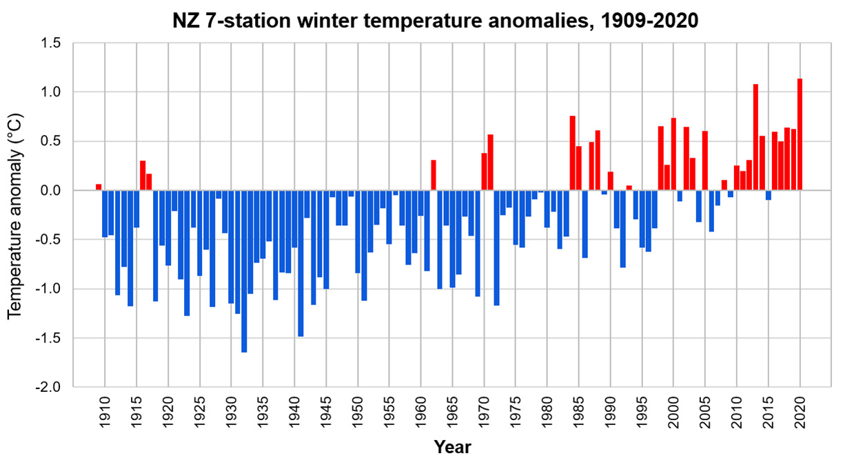
Winter 2020 was New Zealand’s warmest winter on record. The nationwide average temperature was 9.6°C (1.1°C above the 1981-2010 average from NIWA’s seven station temperature series which begins in 1909). Temperatures across the country were generally above average (0.51 to 1.20°C above the winter average) or well above average (>1.20°C above the winter average). Several isolated locations however observed near average winter temperatures (within 0.50°C of the winter average), including Tararua, Kaikoura, and parts of Southland and Otago. |
|
Rainfall |
Rainfall totals in Northland were above normal (120-149% of the winter normal) or well above normal (>149% of the winter normal). Rainfall was below normal (50-79% of the winter normal) for western Waikato and many locations between Taihape and Wellington, and near normal (80-119% of the winter normal) for most remaining North Island locations. In the South Island, southern locations generally observed near normal winter rainfall totals including Southland, much of Otago, and the southern portion of the West Coast region. Remaining South Island locations generally observed below normal (50-79% of the winter normal) or even well below normal (<50% of the winter normal) winter rainfall totals (including the northeastern portion of Otago). |
|
Soil moisture |
At the end of winter, soil moisture levels were near normal for most of the North Island, although soils were drier than normal in parts of the Manawatu-Whanganui and Greater Wellington regions. Soil moisture levels were considerably drier than normal in eastern parts of South Canterbury and North Otago, with NIWA’s New Zealand Drought Index classifying conditions as “very dry” in some areas. Near normal soil moisture levels were found for the remaining majority of the South Island. |
Overview
Winter 2020 was New Zealand’s warmest winter on record. The season was characterised by mean sea level pressures that were higher than normal over, to the east, and southwest of New Zealand, with slightly lower than normal sea level pressure northwest of the country. This pressure pattern delivered more frequent warm northeasterly winds than normal, particularly to the North Island. This pattern was associated with a developing La Niña event in the equatorial Pacific. Sea surface temperatures (SSTs) surrounding New Zealand were also warmer than average during winter, most notably during August, and this exerted a further warming influence on the country’s air temperatures. Additionally, the prevalence of high pressure over the country contributed to a sunnier than normal winter for much of the South Island and lower North Island. This combination of more frequent northeasterlies, warmer SSTs, and higher pressure over the country, along with a background influence of climate change (i.e. a long-term increase in average temperatures), resulted in widespread warm conditions during winter.
The nationwide average temperature for winter 2020 was 9.6°C (1.1°C above the 1981-2010 average from NIWA’s seven station temperature series which begins in 1909), making it New Zealand’s warmest winter on record, beating the previous record set in 2013 by only 0.06°C. Temperatures around the country were generally above average (i.e. 0.51 to 1.20°C above the winter average) or well above average (>1.20°C above the winter average), with only a handful of locations experiencing near average winter temperatures (within 0.50°C of the winter average). The season started and ended on a warm note with New Zealand’s fifth-warmest June, and fourth-warmest August on record. Many locations achieved record or near-record high mean temperatures for the time of year during these months. During the final few days of winter, several locations observed very high daily maximum temperatures, including Timaru at 25.1 °C on 30 August, which was the 4th-equal warmest winter temperature on record for New Zealand.
Rainfall patterns varied spatially month-to-month, however for winter as a whole, below normal rainfall (50-79% of the winter normal) was observed for most of the upper and eastern South Island, as well as western Waikato and many locations in the lower North Island between Taihape and Wellington. Above normal (120-149% of the winter normal) or well above normal (>149% of the winter normal) winter rainfall was observed in Northland, largely attributed to events during July and August, while near normal (80-119% of the winter normal) rainfall for winter was observed for most remaining locations across the country. A particularly noteworthy rainfall event occurred in Northland on 17 July, resulting in daily rainfall totals of 262 mm and 251 mm at Kaikohe and Whangarei. These are the highest maximum one-day rainfall amounts on record for winter at those locations, contributing 28% and 31% of the total rainfall amounts recorded at Kaikohe and Whangarei respectively for winter 2020 as a whole. Several impacts relating to this event are summarised in the highlights and extreme events section.
Further highlights
- The highest temperature was 25.1°C, observed at Timaru on 30 August.
- The lowest temperature was -12.3°C, observed at Middlemarch on 14 June.
- The highest 1-day rainfall was 262 mm, recorded at Kaikohe on 17 July.
- The highest wind gust was 191 km/h, observed at Cape Turnagain on 23 July.
- Of the six main centres in winter 2020, Auckland was the warmest, Christchurch was the coolest, Tauranga was the wettest and sunniest, Dunedin was the driest, and Hamilton was the least sunny.
Download
Winter 2020 seasonal climate summary [PDF 600KB]
