Warm start to summer followed by a cool finish
| Temperature | Summer temperatures were well above average (>1.20°C above average) for small areas of Gisborne and the Coromandel Peninsula, above average (0.51-1.20°C above average) for Northland, Auckland, most of Waikato, Bay of Plenty, remainder of Gisborne, Hawke’s Bay, parts of coastal Westland and western Tasman. Temperatures were below average (0.51°C-1.20°C below average) in the Southern Alps of south Canterbury and Otago. Temperatures were near average (±0.50°C of average) for the remainder of the country. |
| Rainfall | Rainfall was above normal (120-149% of normal) or well above normal (>149% of normal) for coastal Otago, Canterbury, eastern Marlborough, Wellington, the Tararua District, Hawke’s Bay, Gisborne, parts of Manawatū-Whanganui, most of Waikato, southern Taranaki, western Bay of Plenty, Auckland, and eastern Northland. Rainfall was below normal (50-79% of normal) or well below normal (<50% of normal) for southern Westland, parts of interior Otago, and the north and west of Northland, with near normal rainfall (80-119% of normal) for the remainder of the country. |
| Soil Moisture | At the end of summer, soil moisture levels were below normal in the Far North, western Taranaki, Manawatū-Whanganui about Foxton, about Marlborough, Nelson, and parts of Tasman, a few spots in Otago and Westland, and Southland. Soil moisture levels were above normal across coastal Otago, Canterbury about Banks Peninsula, Christchurch, Ashburton, and the Kaikōura region, most of the Wellington region, Tararua District, about Tongariro, Bay of Plenty toward Rotorua, much of Hawke’s Bay, Gisborne, and eastern Northland. Near normal soil moisture levels were typical for the remainder of the country. |
Overview
Summer mean sea level air pressure was lower than normal over Aotearoa New Zealand. The dominant wind pattern over the season was cyclonic, with generally westerly or southwesterly winds across the North Island and southeasterly winds for the South Island. The lower pressure led to an extremely active pattern across the country, at least partially driven by a weak to moderate La Niña. Despite the overall lower pressure, there were extended periods of high pressure in between weather events that occurred in all three summer months. La Niña conditions were prevalent across New Zealand throughout the summer, with the La Niña transitioning to ENSO (El Niño Southern Oscillation) neutral conditions by the end of the summer. Sea surface temperatures (SSTs) around New Zealand were generally above average, however previously existing Marine Heatwave (MHW) conditions[1] experienced early in the summer dissipated by February.
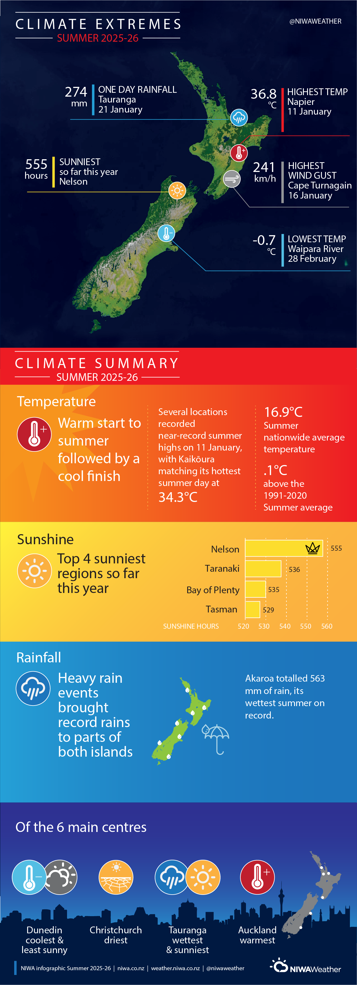
The nationwide average temperature for summer 2025-2026 was 16.9°C. This was 0.1°C above the 1991-2020 summer average, making it an average summer for New Zealand temperature-wise. Earth Sciences New Zealand’s seven station temperature series began in 1909.
Summer temperatures were well above average (>1.20°C above average) for small areas of Gisborne and the Coromandel Peninsula. Temperatures were above average (0.51-1.20°C above average) for Northland, Auckland, most of Waikato, Bay of Plenty, remainder of Gisborne, Hawke’s Bay, parts of coastal Westland, and western Tasman. Temperatures were below average (0.51°C-1.20°C below average) in the Southern Alps and foothills of south Canterbury and Otago. Temperatures were near average (±0.50°C of average) for the remainder of the country.
Summer rainfall was well above normal (>149% of normal) for eastern Northland, parts of Auckland, Gisborne, northern and central Hawke’s Bay, most of the Wellington region, Marlborough about Seddon, most of the Canterbury Plains from Timaru northward including Banks Peninsula and the Kaikōura region. Rainfall was above normal (120-149% of normal) about the Otago Peninsula south to Balclutha, about Picton and Blenheim in Marlborough, South Taranaki, the Manawatū-Whanganui about Tongariro, the Waikato about Taupō to Te Awamutu, and remainder Auckland. Rainfall was below normal (50-79% of normal) about coastal Westland from Haast northward to Greymouth, inland Otago about Alexandra, and the north and west of Northland. The remainder of the country recorded near normal rainfall (80-119% of normal) for the summer.
Further Highlights:
- The highest temperature was 36.8°C, observed at Napier on 11 January.
- The lowest temperature was -0.7°C, observed at Waipara River North Branch on 28 February.
- The highest 1-day rainfall was 274 mm, recorded at Tauranga on 21 January.
- The highest wind gust was 241 km/h, observed at Cape Turnagain on 16 January.
- Of the six main centres in summer 2025-2026, Auckland was the warmest, Tauranga was the wettest and sunniest, Christchurch was the driest, and Dunedin was the least sunny and coolest.
- The sunniest four regions in 2026 so far are wider Nelson (555 hours), Taranaki (536 hours), Bay of Plenty (535 hours), and Tasman (529 hours).
[1] Defined as five or more consecutive days with SSTs above the 90th percentile for the time of year.
