New Zealand’s second consecutive warmest winter on record
|
Temperature |
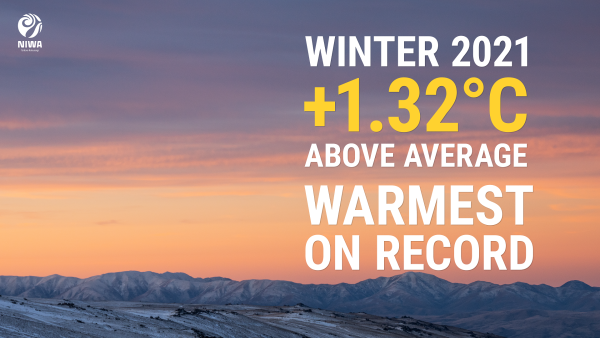
Winter 2021 was the warmest winter on record in Aotearoa New Zealand, surpassing winter 2020 that set the record just last year. Temperatures were above average (+0.51°C to +1.20°C of average) across most of NZ. Pockets of well above average temperatures (>1.20°C above average) were recorded in Northland, Waikato, Wairarapa, Nelson, Tasman, West Coast, Canterbury, and Otago. Isolated near average temperatures (±0.50°C of average) were recorded in Bay of Plenty, Waikato, and southern Canterbury. No areas experienced below average temperatures. |
|
Rainfall |
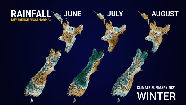
Above normal rainfall (120-149% of normal) was observed in parts of Northland, southern Manawatū-Whanganui, Kāpiti Coast, Wellington City, and large swaths of the upper and western South Island. Pockets of well above normal rainfall (>149% of normal) were observed in Nelson and Marlborough. Winter rainfall was below normal (50-79% of normal) in western Northland, southern Auckland, parts of Gisborne District and Hawke’s Bay, and southern Canterbury. An isolated area of well below normal rainfall (<50% of normal) was observed near Wairoa. Near normal rainfall (80-119% of normal) was observed elsewhere. |
|
Soil moisture |
At the end of winter, soil moisture levels were near normal across most of New Zealand, although a small area of below normal soil moisture levels was were observed from near Napier south to southern Hawke’s Bay. Above normal soil moisture levels were located in eastern Marlborough and northern Canterbury. |
Overview
Winter 2021 was the warmest winter on record in Aotearoa New Zealand, surpassing winter 2020 that set the record just last year. The season began on a particularly warm note, with June 2021 being New Zealand’s warmest June on record. Winter 2021 was also the first winter on record where the temperature anomaly exceeded +0.9˚C for all three months, relative to the 1981-2010 long-term average.
Several factors contributed to this record-setting season, including frequent high pressure over and east of New Zealand, warm northerly-quarter wind flows, warmer than average coastal waters, and the influence of a decaying La Nina early in the season, followed by a trend back toward La Nina late in the season.
Several atmospheric rivers affected New Zealand during winter, causing extreme rainfall in some regions, which was associated with the Madden-Julian Oscillation spending more time in the Indian Ocean and briefly pulsing eastward over the Pacific. This was likely connected to the emergence of a negative Indian Ocean Dipole, which refers to warmer than average ocean temperatures in the eastern Indian Ocean. For New Zealand, this may have allowed for more tropical moisture to become available to passing weather systems.
The Southern Annular Mode (SAM) was strongly positive for June, before becoming weaker and more variable in July and August. The phase and magnitude of the SAM is a reflection of the strength and position of the belt of westerly winds that spans zonally across the Southern Ocean. In its negative phase, the SAM usually results in lower than normal air pressure around New Zealand, reflecting the increased risk for unsettled weather conditions.
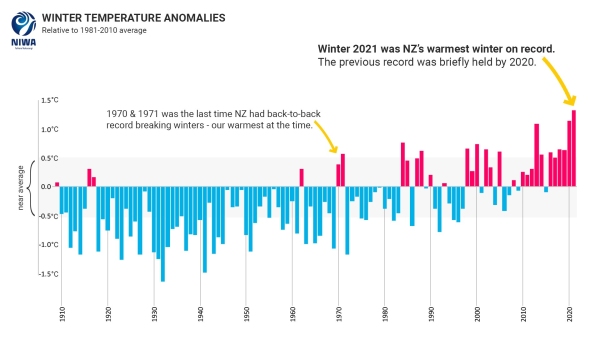
Figure 1 (above) shows winter temperature anomalies of NIWA’s seven-station series relative to the 1981-2010 average. The winters of 1970 and 1971 were the last time New Zealand had consecutive record warm winters prior to 2020 and 2021. However, what was record warmth 50 years ago is no longer unusual. The winter of 1971 now stands in 13th place on the winter temperature rankings, while the winter of 1970 is in 18th place. In fact, the once record-breaking warm winter of 1971 was 0.75°C cooler than the winter of 2021.
The nationwide average temperature for winter 2021 was 9.7°C (1.3°C above the 1981-2010 average from NIWA’s seven-station temperature series which begins in 1909), making winter 2021 the warmest winter on record. No locations experienced below average temperatures in winter 2021.
Winter rainfall was above normal (120-149% of normal) in parts of Northland, southern Manawatū-Whanganui, Kāpiti Coast, Wellington City, and large swaths of the upper and western South Island. This included Westport and Buller District, which experienced severe flooding in mid-July. Pockets of well above normal rainfall (>149% of normal) were observed in Nelson and Marlborough. Winter rainfall was below normal (50-79% of normal) in western Northland, southern Auckland, parts of Gisborne and Hawke’s Bay, and southern Canterbury. A pocket of well below normal rainfall (<50% of normal) was observed near Wairoa. Near normal rainfall (80-119% of normal) was observed elsewhere.
Further highlights for winter 2021:
- The highest temperature was 23.0°C, observed at Akaroa and Orari Estate on 24 August.
- The lowest temperature was -9.1°C, observed at Lake Tekapo on 9 August.
- The highest 1-day rainfall was 210 mm, recorded at Arthur’s Pass on 16 July.
- The highest wind gust was 191 km/h, observed at Cape Turnagain on 28 June.
- Of the six main centres in winter 2021, Auckland was the warmest and sunniest, Christchurch was the coolest, Wellington was the wettest, and Dunedin was the driest and least sunny.


