A weekly update describing soil moisture patterns across the country to show where dry to extremely dry conditions are occurring or imminent. Regions experiencing significant soil moisture deficits are deemed “hotspots”. Persistent hotspot regions have the potential to develop into drought.
Recent rainfall and current soil moisture conditions:
North Island:
- Rainfall of 30-60 mm was observed in small pockets of southern Waikato, Taranaki, and the lower North Island during the past week.
- However, in a majority of the upper and eastern North Island, weekly rainfall totals were generally 5-20 mm.
- This resulted in small to moderate soil moisture decreases across a majority of the North Island.
- The driest soils across the North Island, when compared to normal for this time of the year, are found near East Cape, while the wettest soils for this time of the year are found in southern Gisborne and northern Hawke’s Bay.
- No hotspots currently exist in the North Island.
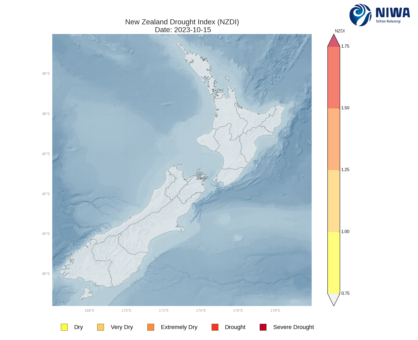
- As of 15 October, the New Zealand Drought Index (NZDI) map below shows that no unusually dry conditions are currently found across the North Island.
South Island:
- Rainfall of 75-200 mm occurred across most of the West Coast in the past week, including Tasman.
- Amounts of 30-60 mm were observed in interior Canterbury and Marlborough Sounds.
- The east coast from Marlborough to Southland saw amounts of 15-25 mm.
- This resulted in soil moisture increases across a majority of the South Island, with the largest increases observed in Tasman, the West Coast, and interior Canterbury.
- The driest soils across the South Island, when compared to normal for this time of the year, are found in Marlborough Sounds, while the wettest soils for this time of the year are found in northern Canterbury.
- No hotspots currently exist in the South Island.
- As of 15 October, the New Zealand Drought Index (NZDI) map below shows that no unusually dry conditions are currently found across the South Island.

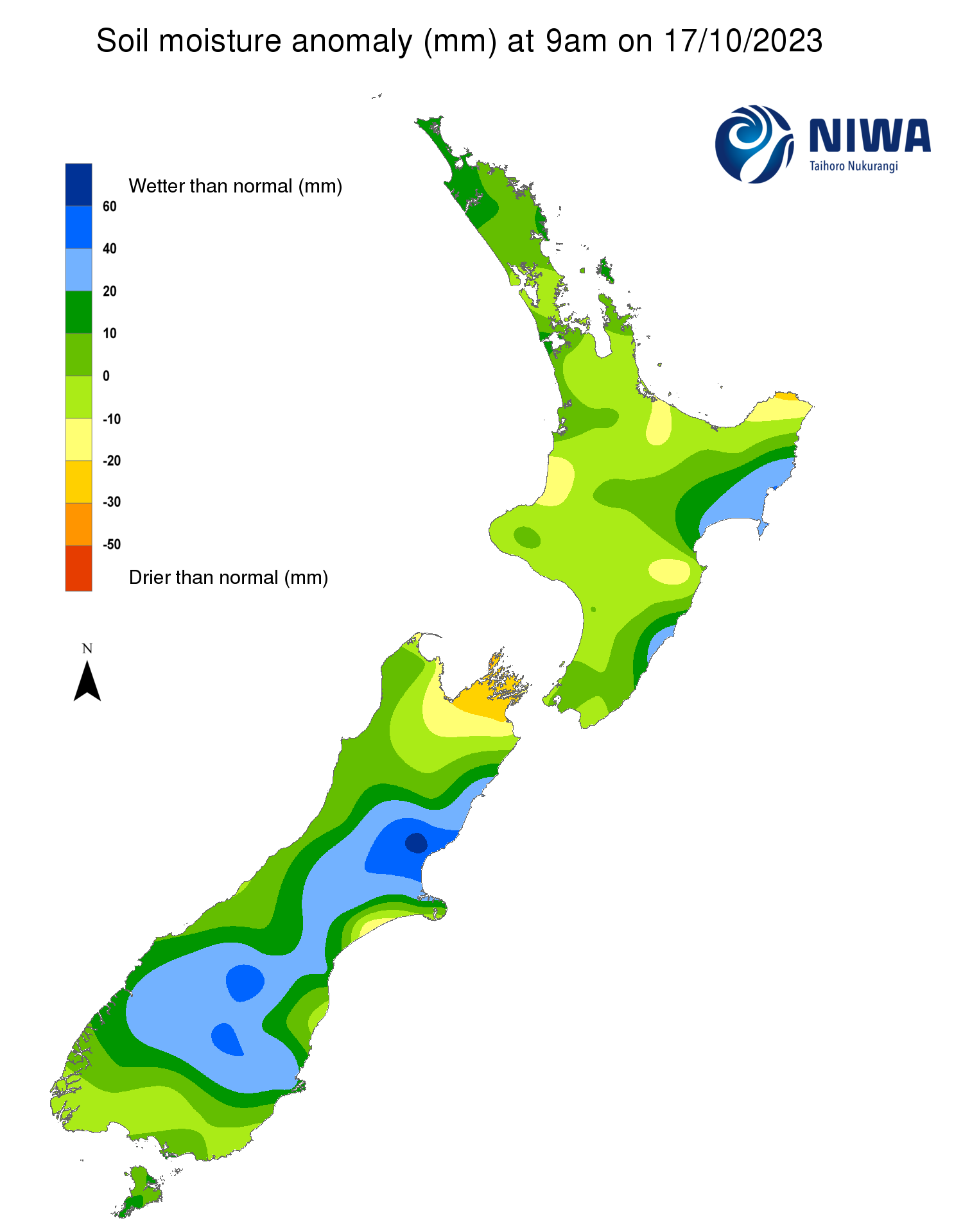
Pictured above: Soil Moisture Anomaly Maps, relative to this time of year. The maps show soil moisture anomalies over the past two weeks.
New Zealand Drought Index (NZDI) map
As of 15 October, the New Zealand Drought Index (NZDI) map shows that no unusually dry conditions are currently found across the country.
Please note: some hotspots in the text above may not correspond with the NZDI map. This difference exists because the NZDI uses additional dryness indices, including one which integrates the rainfall deficit over the past 60 days.
Changes are therefore slower to appear in the NZDI compared to soil moisture anomaly maps that are instantaneously updated.
The week ahead:
North Island:
- Low pressure north of Cape Reinga will bring moderate rain to Northland on Thursday and Friday (19-20 October), while other areas remain mostly dry.
- Scattered showers and isolated thunderstorms will be possible during the upcoming weekend, but rainfall will be very localised.
- After generally dry weather on Monday (23 October), a front could bring moderate rain by late Tuesday or Wednesday (24-25 October).
- Weekly rainfall totals of 30-50 mm will be possible in Northland and parts of the western North Island, with most other locations receiving 15-30 mm.
- Due to the expected rainfall in the next week, soil moisture levels may increase slightly in Northland and parts of the western North Island, but little change is expected elsewhere.
- No hotspots are expected to form in the North Island in the next week.
South Island:
- High pressure will generally be in control of the South Island’s weather over the next several days.
- Between Thursday and Monday (19-23 October), only scattered showers will affect the eastern and lower South Island with generally light rainfall amounts.
- However, towards the middle of next week, low pressure could bring moderate rain to the West Coast.
- Weekly rainfall totals of 25-50 mm are expected along the West Coast and Tasman.
- However, for locations east of the divide, along with the lower South Island, weekly rainfall totals are likely to be 15 mm or less.
- Due to the expected rainfall in the next week, soil moisture levels are likely to decrease across most regions, with the largest decreases expected in the eastern South Island.
- No hotspots are expected to form in the South Island in the next week.
Long-term outlook (through mid-November):
- El Niño is expected to bring more westerly air flows than normal to New Zealand over the next several weeks, although periodic southerlies are also likely.
- The drier (25th percentile) scenario for rainfall over the next 35 days indicates that the West Coast of the South Island could see near normal rainfall, while much of the North Island and eastern and lower South Island are favoured to see near normal to below normal rainfall.
- However, in the wetter (75th percentile) scenario, parts of the North Island and upper South Island could see above normal rainfall.
- Even in the drier rainfall scenario, there is currently only a muted signal for dry conditions to emerge in parts of the eastern South Island over the next 35 days.
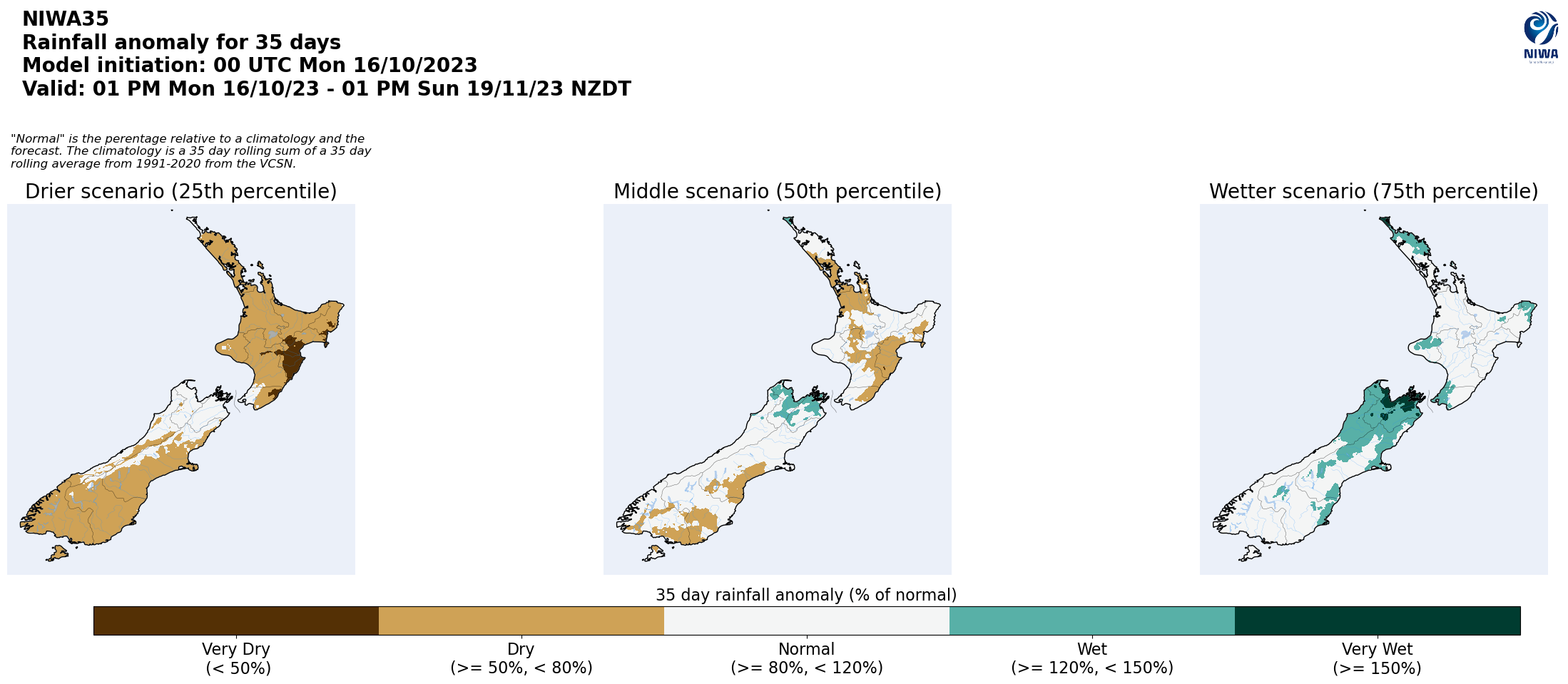

Pictured above: 35-day forecast rainfall anomaly scenarios (Top), and 35-day forecast dryness and drought scenarios (Bottom). These maps are updated daily at https://niwa.co.nz/climate/seasonal-climate-outlook
Background:
Hotspot Watch: a weekly advisory service for New Zealand media. It provides soil moisture and precipitation measurements around the country to help assess whether extremely dry conditions are imminent.
Soil moisture deficit: the amount of water needed to bring the soil moisture content back to field capacity, which is the maximum amount of water the soil can hold.
Soil moisture anomaly: the difference between the historical normal soil moisture deficit (or surplus) for a given time of year and actual soil moisture deficits.
Definitions: “Extremely” and “severely” dry soils are based on a combination of the current soil moisture status and the difference from normal soil moisture (see soil moisture maps).
Hotspot: A hotspot is declared if soils are "severely drier than normal" which occurs when Soil Moisture Deficit (SMD) is less than -110 mm AND the Soil Moisture Anomaly is less than -20 mm.
