PDF of this article (183 KB)


Jim Salinger, Trevor Chinn, Andrew Willsman, and Blair Fitzharris explain how fluctuations in New Zealand glaciers reflect regional climate change.
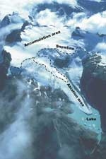
Glaciers are large-scale, highly sensitive climate instruments which, ideally, should be picked up and weighed once a year. Their fluctuations are among the clearest signals of climate change. A glacier is simply the surplus ice that collects above the permanent snowline where the losses to summer melting are less than the gains from winter accumulation. This creeping cap of annual layers, the névé, formed over many decades of winter snowfalls, is balanced lower down the mountain by losses to as many decades of summer melt. The higher the mountain rises above the permanent snowline, the more surplus snow accumulates, and the larger the glacier formed. A glacier always crosses the permanent snowline from the area of snow gain to the zone of ice loss. The altitude of this permanent snowline is the equilibrium line: it marks the altitude at which snow gain (accumulation) is exactly balanced by melt (ablation).
If the temperature or snowfall changes even a little, the altitude of the equilibrium line shifts dramatically, with consequent change to the volume of the glacier. It is this mass balance that makes glaciers sensitive climate instruments that record year-by-year climate in the mountains.
How glaciers are measured
The most direct way to measure a glacier is to measure the annual mass balance change. This requires a field team to venture onto the glacier throughout winter and summer to measure mass changes at a set of stakes. It is arduous and expensive work. As a more economic alternative, each year NIWA scientists use aerial photography to measure the end-of-summer snowline for 50 index glaciers throughout the Southern Alps. From these images we are able to estimate annual glacier mass balance. The aerial survey has been made in most years for the past three decades.
Individual glaciers’ response times to changes in climate vary from 5 to more than 100 years, so it’s risky to use any one patch of ice as a benchmark for regional climate change. Most of the small, steep alpine glaciers respond quickly, rolling a wave of newly gained ice down to their terminus to appear as an advance in 5 to 15 years. Franz Josef and Fox, two of the large glaciers in the Southern Alps, are also exceptionally responsive to small changes. Ice from their accumulation zone ‘squirts’ down their steep, narrow valleys in 5 to 8 years; they are among the most sensitive of New Zealand glaciers and their fluctuating terminus positions give a detailed summary of the climate.
In contrast, the lower trunk of long, low-gradient glaciers, such as Tasman, behaves as a creeping body of ice with a thick covering of insulating debris. Its response to snow gain in the accumulation zone is subdued and takes many decades longer.
Two climate regimes, two types of glacier
The most recent maximum extent of glaciers was at the end of the last cool period for our region. This was the Little Ice Age, or LIA, a period of glacier expansion that reached a maximum in the Southern Alps in the 17th and 19th centuries. Then there was some warming from about 1910 to the mid 1970s, andespecially in the 1950s, which caused a massive wastage of glaciers. In 1977 the second phase started, coincidentally just as we began our programme of annual surveys. Despite continued regional warming, this phase has been a time of alternating gains and losses, resulting in a nearzero ice-mass change of the Southern Alps glaciers over the last three decades.
Superimposed on these two different climatic phases are the contrasting responses of the two types of glaciers. During the 65 years of the first phase, glacial retreat was massive. Most of the numerous fast-response, small and moderate-sized glaciers had shrunk enough to remain in near equilibrium with climatic warming. Thus these were free to respond to the positive snow gains of the second phase, and have advanced and receded with the fluctuations in climatic circulation of the last three decades. Some fast-response glaciers have fluctuated over the last 30 years and are now the same size as they were in 1977, even though the climate has been warming.
Not so the larger debris-mantled glaciers, however; these have continued to adjust to the post-1910 warming phase, through to the present. Their long response times have meant that they have simply absorbed any snow gains into their shrinking masses, maintaining their areas while their surfaces have lowered like sinking lids. These glaciers have kept their LIA areas for all but the last couple of decades. Most of the relatively thick ice filling their over-deepened valleys was a remnant from the LIA, insulated by mantles of rocky moraine. They lost ice only by slow surface melt, with little or no terminus retreat. Rapid glacial lake expansion and glacier calving is now changing this situation.
Results of our surveys
Using the glacier mass balance surveys based on glacier snowline elevations, we have found that the slight warming since 1977 has been paired with more westerly atmospheric circulation over New Zealand. This has increased snowfall justenough to overcome the temperature increase and allowed the glaciers to gain mass. Very reactive glaciers like Fox, Franz Josef, and hundreds of steep mountain glaciers, which rapidly pass their ice gains down to their termini, have all fluctuated.
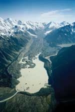
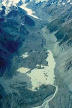
For the big glaciers, glacial lakes have begun to form at their fronts as lowering ice levels reach the level of their outlet rivers. Once a lake has formed, it eats at the glacier far faster than surface melt. At the front of the glacier, the ice cliff calves bergs into the lake. This positive feedback ensures a massive and catastrophic depletion of the glacier volume, creating an irreversible tipping-point for the glacier. It would take an ice age climate to drive the glacier back across the lake and to reverse the process.
In early 2007 we used the snowline survey data plus topographic maps and a GPS survey of the ice levels of the larger glaciers to calculate total ice-volume changes for the Southern Alps. Between 1976 and 2005 the volume decreased more than 10%, from 54.60 km3 to 48.74 km3. More than 92% of this loss is from 12 of the largest glaciers: Ramsay, Godley, Grey, Maud, Balfour, La Perouse, Classen, Murchison, Tasman, Hooker, Volta, and Therma. This loss is an on-going response to regional warming of about 1 °C since the late 1800s.
For these largest valley glaciers, only a small loss in ice volume is due to annual climatic mass balance changes (0.49 km3), compared to massive loss due to calving into growing glacial lakes (0.63 km3) and melting of the glacier tongue or trunks (5.37 km3).
Lakes as agents of change
Lyell Glacier has been in equilibrium since it retreated from Lyell Lake over 10 years ago, while Ramsay Lake is still growing. Godley Glacier is also close to reaching equilibrium after a particularly massive retreat. But while these more remote glaciers have reached some form of balance, others, such as Tasman, haven’t. Tasman Lake in particular has yet to almost double in size before the glacier shrinks enough to reach equilibrium with the climate. Murchison Lake is just starting and the glacier is collapsing into the separate trunks of its lower tributaries. The lowering ice levels have released the confining ice pressure against the lateral moraines, and these are prone to slumping into the lake.
Despite the vast quantities of ice that have been lost in the Southern Alps because of regional warming in the last 30 years, the complete disappearance of our glaciers is a distant prospect. As long as there is a snowline there will be glaciers. However, by eating away at the glaciers, the relatively recently formed glacier lakes are causing rapid ice loss. With more warming expected during the 21st century, further large losses of ice in the Southern Alps are very likely.
Balance sheet
- Glacier response to regional climate can be deduced from changes in their mass balance and ice volume.
- Individual response time varies with the type of glacier: short glaciers respond rapidly, while long glaciers may take decades.
- Annual surveys indicate that glaciers in the Southern Alps have lost more than 10% of their ice volume since 1977.
Glacier terminology
Permanent snow line – altitude above which snow does not melt in summer
Névé – mass of compacted, granular snow
Equilibrium line – boundary between the ablation area and accumulation area where no net mass is gained or lost
Accumulation – zone of input of ice to a glacier
Ablation – zone of net ice loss
Mass balance – net gain or loss of snow and ice
Terminus – end of a glacier, also known as a snout
Trunk – main portion of glacier
Moraine – debris deposited by a melting glacier
Calving – ice masses breaking off the glacier face
Tongue – any narrow extension of a glacier
Trimline – glacier scour line on the side of a valley
Dr Jim Salinger is a principal climate scientist with NIWA in Auckland; Dr Trevor Chinn is a consultant glaciologist based in Lake Hawea; Andrew Willsman is a field technician with NIWA in Dunedin; and Dr Blair Fitzharris is an Emeritus Professor in the Geography Department at the University of Otago.
Teachers’ resource for NCEA Achievement Standards or Unit Standards: Environmental Sustainability Level 2 AS90811 Geography Level 2 AS90331, AS90334, US5089, Level 3 AS90704, US5095, US90701 Science Level 2 US6352, Level 3 US6355, US21614
