-
Climate data and activities
We provide an overview of New Zealand climate data for use in school projects. -

Electronic Weather Station - NIWA EWS
These gather top-quality data and are used throughout New Zealand in the National Climate Network. -

UVI smartphone apps
Several apps that provide forecasts of the UV index (UVI) are available for smartphones. -
SolarView help
This calculator estimates the solar energy that can be collected by a solar capture device (solar panel) at a given address, panel direction and roof slope. -
Inanga
Inanga are the predominant species in the modern whitebait fishery. -
Impacts of wood processing
Impacts of timber processing activities on water quality and mahinga kai. -
Soil Moisture Deficit (SMD)
The 3-panel Soil Moisture Deficit (SMD) map shows the historical soil moisture deficit at the date shown (left), the soil moisture deficit at the same time last year (middle) and the current soil moisture deficit (right). -
What is the chance of a warm summer in Invercargill?
In this activity you will analyse the Southern Oscillation Index and investigate the chances of getting below normal, normal or above normal summer temperatures in Invercargill. -
Map Chatham
Education ResourceExtremes of temperature are rare as the Chatham Islands are small land masses surrounded by sea. -
Marine geological hazards
Education ResourceNew Zealand faces a variety of hazards associated with undersea geological activity. -
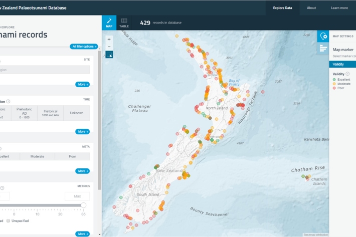
New Zealand Palaeotsunami Database
Software Tool/ResourceThe New Zealand Palaeotsunami Database (Database) brings together all known information about tsunamis that occurred prior to written records. -
Tuna - recreational fisheries
The majority of New Zealanders are able to recall a story about catching eels when they were children.