PDF of this article (731 KB)

Pip Nicholls Joanne Ellis
Investigations into changes in salt marsh and mangrove communities are confirming the important role of increasing sedimentation.
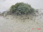
Fringing plant communities, such as salt marshes and mangroves, play an important role in our estuaries and coastal ecosystems. These fringing habitats are a key source of organic material and nutrients, which help to fuel the estuarine food web. Stems and leaves of salt marsh and mangrove plants provide a three-dimensional structure in which animals can hide from predators, and they create habitat for fish species and wading birds.
Fringing habitats also act as physical buffers between the land and the sea. Branches and stems of plants reduce water flows and dissipate wave action, while root–rhizome mats stabilise and bind marine sediments, preventing erosion. Reduced water flows enhance sediment settling, and therefore fringing habitats act as sinks for sediments and pollutants that are washed down or leach out from land-based sources.
New Zealand’s growing population and the catchment development that goes with it are leading to greater sediment deposition in our estuaries and coastal ecosystems. Estuaries and tidal inlets are particularly vulnerable because these places act as natural retention systems. If sediments from the land are deposited faster than usual, then habitats may be altered. Such changes can kill, displace, or damage parts of the plant and animal communities. The severity of impact depends on the frequency of depositional events and can vary considerably. Ecological repercussions can be both catastrophic (short-term) and chronic (long-term).
In an ongoing research programme we are investigating possibilities for predicting and managing these changes. This includes assessing the impacts of changes on the distribution and functioning of fringing habitats.
Studies in two estuaries
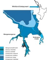
To understand how estuaries respond to long-term increasing sediment inputs we are studying two estuary systems in the Whitford embayment, Auckland: Mangemangeroa and Waikopua Creek.
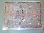
We have used photographic records along with data relating to sediment deposition, both dating back 45 years, to map historical distributions of mangrove (Avicennia marina var. australasica) and salt-marsh plants. Using sediment cores, we have been able to quantify sedimentation rates in both estuaries. When combined with information about currents and tides, this has enabled us to make predictions about the influence of mangroves on depositional patterns.
In addition, individual mangrove and salt-marsh plants are being measured routinely at places with different degrees of sedimentation, to determine how fast the plants grow, how many die off and how many new plants establish. Finally, we have been assessing the abundance of large invertebrates such as cockles (Austrovenus stutchburyi) and crabs. All this information helps us to determine the relationships between changes in sedimen-tation levels, plant health, and the associated changes in animal communities that live within these fringing habitats.
Long-term changes
Of the two estuaries, Mangemangeroa has the greatest sediment loading and rate of sediment accumulation. Since 1953, 1 m of sediment has accumulated at the inland end of the estuary, but only 0.1 m at the estuary mouth. This difference is the result of varying physical conditions in different locations. At its upper end, the catchment is steep with highly erodible soils. In addition, this part of the estuary is protected from wind and wave activity that would normally resuspend and transport sediments farther downstream. The aerial roots of dense mangroves are likely to reduce water flows further, trapping sediment.
Photographs indicate that changes in the distribution of salt-marsh communities in the Whitford embayment have been slight over the past 50 years. However, between 1955 and 2000 mangrove cover increased by 50% in Mangemangeroa, and by 75% in Waikopua Creek. In Mangemangeroa most of the increase in mangrove distribution has been limited to the upper part of the estuary. However, at Waikopua Creek mangroves have also extended their distribution seaward, onto intertidal flats.
Analysis of core profiles at Waikopua indicates a decrease in particle size in denser mangrove stands or areas with low wave activity. This suggests that mangroves can provide sheltered settling areas for fine silts and clay by modifying water flow patterns. In addition, they may accelerate their own rates of spread by trapping mud, and subsequently providing a suitable habitat to colonise.
Mangroves and mud
Results from our plant monitoring in different sediments showed a number of correlations with sediment mud content. Mangrove tree height and growth decreased with distance down the estuary and taller mature trees and saplings grew faster in the upper, muddy parts of the estuary. This was expected since mangroves prefer lower salinity and wind-protected areas and they grow well in organic and nutrient-rich sediments. We found that significantly more young mangroves grew from propagules or seed in the upper more muddy reaches of Mangemangeroa. In addition, plants in this area contained more pneumatophores (breathing roots – an adaptation to ensure an adequate O2 supply to tissues in the finer muds).
Macrofauna
There were differences in invertebrate community composition between sites. In the spreading mangrove areas closer to the estuary mouth there was a greater abundance of pipi, cockles and polychaete worms, whereas in the upper estuary, highly sedimented mangrove habitats, there was a greater abundance of mud crabs and oligochaete worms. In general, for both estuaries we observed the greatest species diversity in the mangrove sites that were nearest to the mouth.
Implications and future research
Research to date suggests that further increases in rates of sedimentation into the Whitford estuary will result in increased spread of mangroves – as has already been observed in other Auckland estuaries. The rates of spread are likely to be limited by hydro-dynamic parameters such as the influence of wind-waves in remobilising sediments.
The encroachment of mangroves onto the sand flats at Waikopua could have important implications for the ecological functioning of this estuarine system. It will probably mean that the proportion of habitat types will change, resulting in a subsequent loss of other associated intertidal habitats.
All these results will contribute to our knowledge of the relationships between salt marsh/mangrove distributions and differing sediment regimes. Research continues to determine how changes in the distribution of fringe habitats affect animal communities. Findings will improve our understanding of the implications of changes in distribution of fringing habitats for the health and functioning of the estuarine ecosystem as a whole.
Teachers: this article can be used for Biology L7 A.O. 7.1a. See other curriculum connections at www.niwa.co.nz/pubs/wa/resources
Pip Nicholls is based at NIWA in Hamilton; Joanne Ellis was formerly based at NIWA in Hamilton.
Further reading
Bell, R.; Green, M.; Hume, T.; Gorman, R. (2000). What regulates sediment in estuaries? Water & Atmosphere 8(4): 13–16.
This work has been funded by the FRST programmes “Effects of Sediment on Estuarine and Coastal Ecosystems” (C01X0024) and “Sustainability of Aquatic Ecosystems and Water Resources” (C01X0215).
