During December 2010 – February 2011, a region of suppressed convection is likely in the southwest Pacific encompassing...
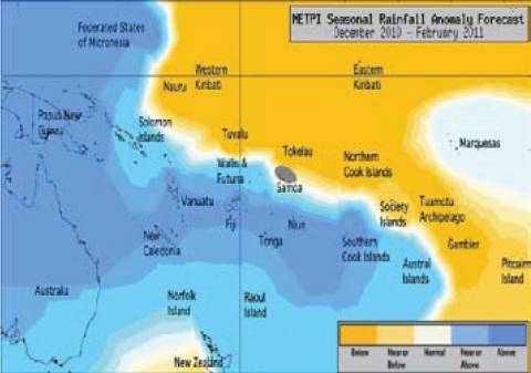
During December 2010 – February 2011, a region of suppressed convection is likely in the southwest Pacific encompassing Eastern Kiribati, Tuvalu, Tokelau, the Tuamotu Archipelago, the Northern Cook Islands and Western Kiribati. Below average rainfall is expected for those island groups. Average or below average rainfall is expected for Pitcairn Island and the Society Islands. Enhanced convection is likely along the Southwest Pacific Convergence Zone, which is expected to be displaced to the southwest of normal. Papua New Guinea, Fiji, New Caledonia, Niue, Tonga, Vanuatu, and the Southern Cook Islands are expected to receive above normal rainfall for the coming three month period. Near or above average rainfall is forecast for Wallis & Futuna, the Solomon Islands, and the Austral Islands. Near normal rainfall is forecast for the Marquesas. No clear precipitation guidance is offered for Samoa.
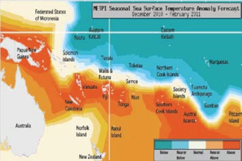
The ensemble of global models continue to show negative equatorial Pacific sea surface temperature anomalies in the coming months, and a cold tongue panning the International Date line. Above average SSTs are forecast for Papua New Guinea, Vanuatu, New Caledonia, Fiji, Niue, Tonga, the Southern Cook Islands and the Austral Islands. Average or above average sea surface temperatures are forecast for Pitcairn Island. Near or below normal SSTs are forecast for the Northern Cook Islands, the Tuamotu Archipelago, Tuvalu and Tokelau, while below normal SSTs are anticipated for Western Kiribati, Eastern Kiribati, and the Marquesas. Near normal SSTs are forecast for Samoa, the Solomon Islands, Wallis & Futuna, and the Society Islands.
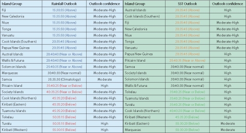
The forecast confidence for the rainfall outlook is moderately high. The average region–wide hit rate for rainfall forecasts issued in December is 69%, 8% higher than all months combined. The SST forecast confidence is mostly high, with uncertainty localised near Eastern Kiribati and the Marquesas.

Rainfall anomaly outlook map for December 2010 to February 2011

SST anomaly outlook map for December 2010 to February 2011

NOTE: Rainfall and sea surface termperature estimates for Pacific Islands for the next three months are given in the tables above. The tercile probabilities (e.g., 20:30:50) are derived from the averages of several global climate models. They correspond to the odds of the observed rainfall or sea surface temperatures being in the lowest one third of the distribution, the middle one third, or the highest one third of the distribution. For the long term average, it is equally likely (33% chance) that conditions in any of the three terciles will occur. *If conditions are climatology, we expect an equal chance of the rainfall being in any tercile.
