A moderate to strong La Niña event is in place in the tropical Pacific, and appears to be near or just past its maximum intensity.
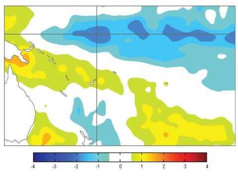
A moderate to strong La Niña event is in place in the tropical Pacific, and appears to be near or just past its maximum intensity. There is strongly enhanced convection over the eastern tropical Indian Ocean, parts of the Maritime Continent and northern Australia. Convection is strongly suppressed near the equator in the western and central Pacific. The ITCZ and SPCZ both remain displaced poleward of their normal position. The TRMM ENSO index eased to –1.0 for November, reduced from –1.4 in October (values of –1.0 or less are considered typical of La Niña conditions). The easterly trade winds are stronger than normal west of 160°W and the SOI was +1.5 for November (+1.9 in the three–month mean for SON). A prominent cold tongue is visible in the SST anomaly field, centred on the Equator and extending from 160°E to the South American coast. SST anomalies are positive in the far western Pacific and in the extra–tropics of both hemispheres. NINO3 and NINO4 SST anomalies eased slightly in November, being about –1.3°C and –1.1°C respectively (SON averages –1.3°C and –1.2°C, respectively). A strong negative subsurface heat content anomaly continues to migrate eastwards along the Equator but has begun to weaken. A positive anomaly is near–stationary in the western Pacific. The MJO shows very little amplitude at present.
Almost all the models NIWA monitor predict the tropical Pacific to be in a La Niña state over the coming three months, with most easing towards neutral conditions during autumn (MAM) and into winter. The NCEP ENSO discussion of 4 November states that La Niña conditions are likely to persist at least into southern autumn 2011. The IRI summary of 18 November indicates a 99% probability for moderate–strong La Niña conditions continuing through January 2011, 92% through March 2011, and at least 50% until April–June 2011.

Surface temperature anomalies (ºC) for November 2010
