NIWA's Hotspot Watch is a weekly update describing soil moisture across the country to help assess whether severely to extremely dry conditions are occurring or imminent.
Regions experiencing these soil moisture deficits are deemed “hotspots”. Persistent hotspot regions have the potential to develop into drought.
Soil Moisture
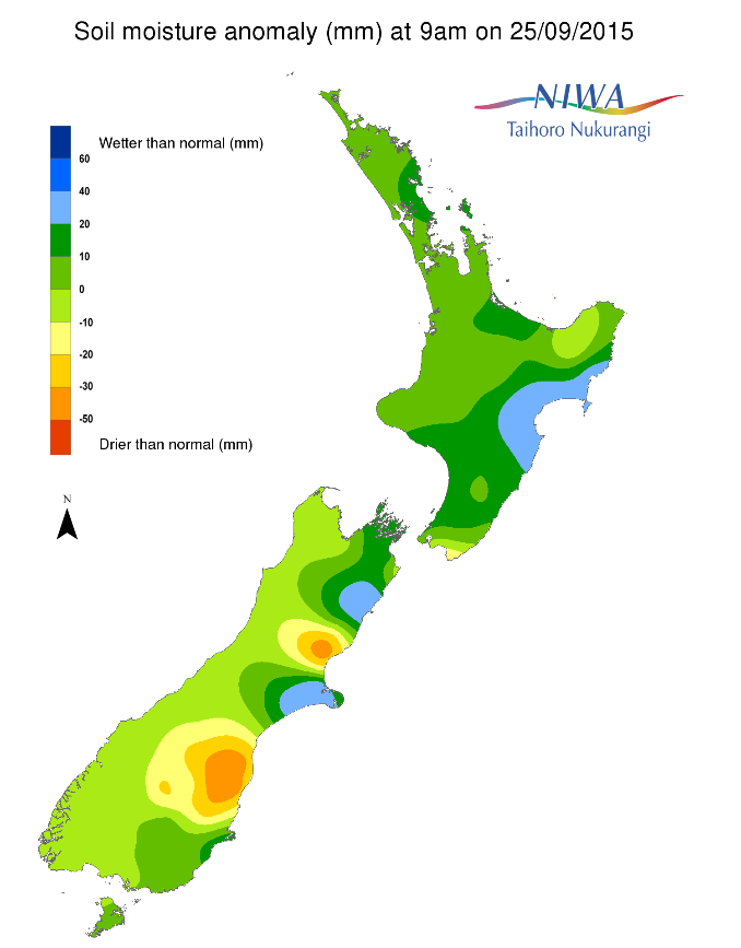
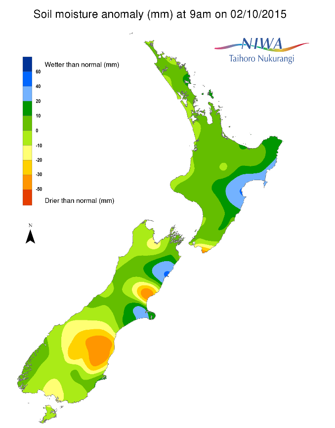
For much of the North Island, soil moisture levels are near to even above normal for this time of year. There has been little, if any, meaningful change from this time last week to soil moisture levels for nearly the whole of the island. The exception is for coastal areas of South Wairarapa. Over the past week, soil moisture levels have decreased and the area of deficit has expanded slightly north. Farther north and east, the effects of widespread and heavy rain from last week continue to be felt from southeastern Gisborne through to Hawke’s Bay, where wetter than normal soils for this time of year exist.
In the South Island, soil moisture levels are much drier to severely drier than normal for this time of year for northeastern Otago as well as for northern and southern sections of eastern Canterbury. Over the past week, this area of severe to extreme dryness has grown slightly. Additionally, drier than normal soils for this time of year have developed in the remainder of Otago, apart from southeastern coastal regions, as well as in portions of the West Coast, southeastern Southland, Tasman and Nelson regions. Pockets of wetter than normal soil moisture for this time of year are present from near Ashburton to Christchurch as well as in northern eastern Canterbury, around and south of Kaikoura. The rest of the island is experiencing near normal soil moisture levels for this time of year.
Outlook
For the North Island, any rainfall is likely to be scattered after this weekend. Consequently, it’s likely that soil moisture levels will decrease by next Friday with parts of Taranaki, northern Manawatu-Wanganui and western Waikato trending toward drier than normal soils for this time of year. However, due to the antecedent conditions impacts should not be significant. The exception is likely to be over the far southern and southeastern parts of the island, where soils moisture may reach severely drier than normal levels for this time of year, particularly south of Masterton and east of Wellington City.
For the South Island, rainfall should be significant enough from Southland, areas west of the Divide and possibly portions of central Otago to alleviate any usual dryness and keep soils at near normal levels for this time of year. East of the Divide, and for northern parts of the island, weekly rainfall is likely to be near or below normal. Consequently, soil moisture levels are likely to decrease over the next seven days for much of the remainder of the island with soils drying east of the Divide and the north of the island.
As a result, a hotspot exists in north and northeast Otago through to southern sections of east Canterbury. Another hotspot is located in north-central parts of eastern Canterbury, roughly north of Christchurch and south of the Waiau River.
Background
Hotspot Watch is a weekly advisory service for New Zealand media. It provides soil moisture and precipitation measurements around the country to help assess whether extremely dry conditions are imminent.
Soil moisture deficit
Soil moisture deficit is the amount of water needed to bring the soil moisture content back to field capacity, which is the maximum amount of water the soil can hold.
Soil moisture anomaly
Soil moisture anomaly is the difference between the historical normal soil moisture deficit (or surplus) for a given time of year and actual soil moisture deficits.
Definitions
“Extremely” and “severely” dry soils are based on a combination of the current soil moisture status and the difference from normal soil moisture
View NIWA’s soil moisture maps
Soil moisture anomaly maps
Pictured below soil moisture anomaly maps, relative to this time of year. The maps compare last week’s soil moisture anomaly with today’s.