Climate change means more intense storm systems are on their way. Science can’t stop it raining, but it can help communities prepare for the worst and plan for the future. Jessica Rowley travelled to the West Coast to see what that means when the storms roll in.
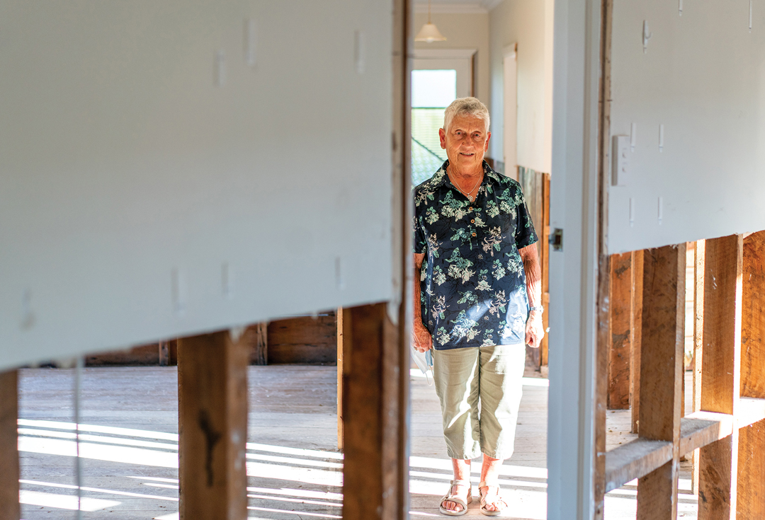
Dorothy Burrows is the epitome of ‘Westport born and bred’. In her eighties, she’s lived in the West Coast town all her life. Her house has been in the family for over a century.
“When I was knee-high to a grasshopper, I can vaguely remember visiting my grandparents here. They inherited it from my great-grandparents. But it was just a small cottage back then.”
Like a decades-long game of Lego, the house has had something added to it by each generation.
“When we moved in, we fitted the aluminium windows, built the deck, and put in a new roof. Everybody has contributed.”
But on the evening of 15 July 2021, dark storm clouds rolled in, and Dorothy started to hear an ominous “pitter-patter” on her roof.
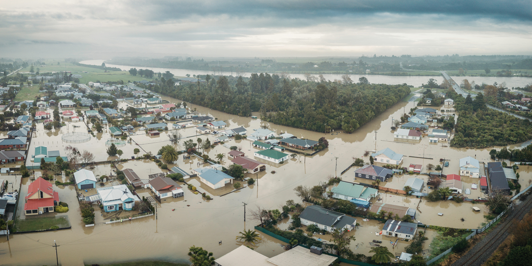
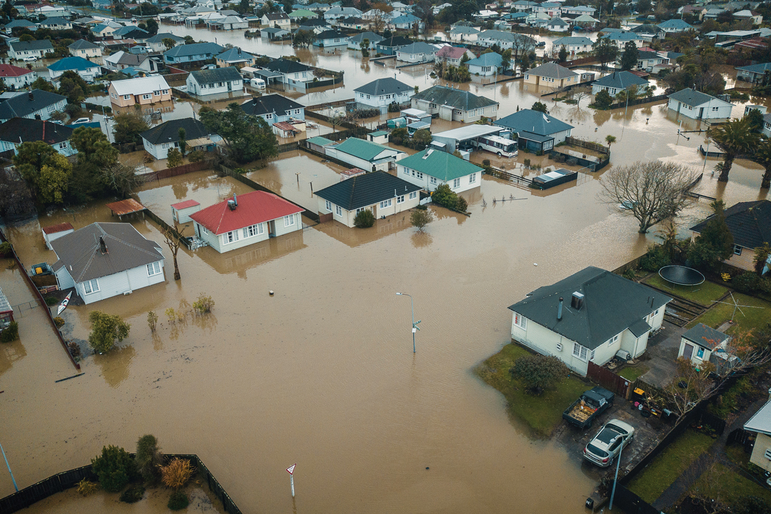
Over the next 3 days, 690mm of rain plummeted down on the West Coast. The Buller River swelled, and a flood of almost biblical scale descended on Westport.
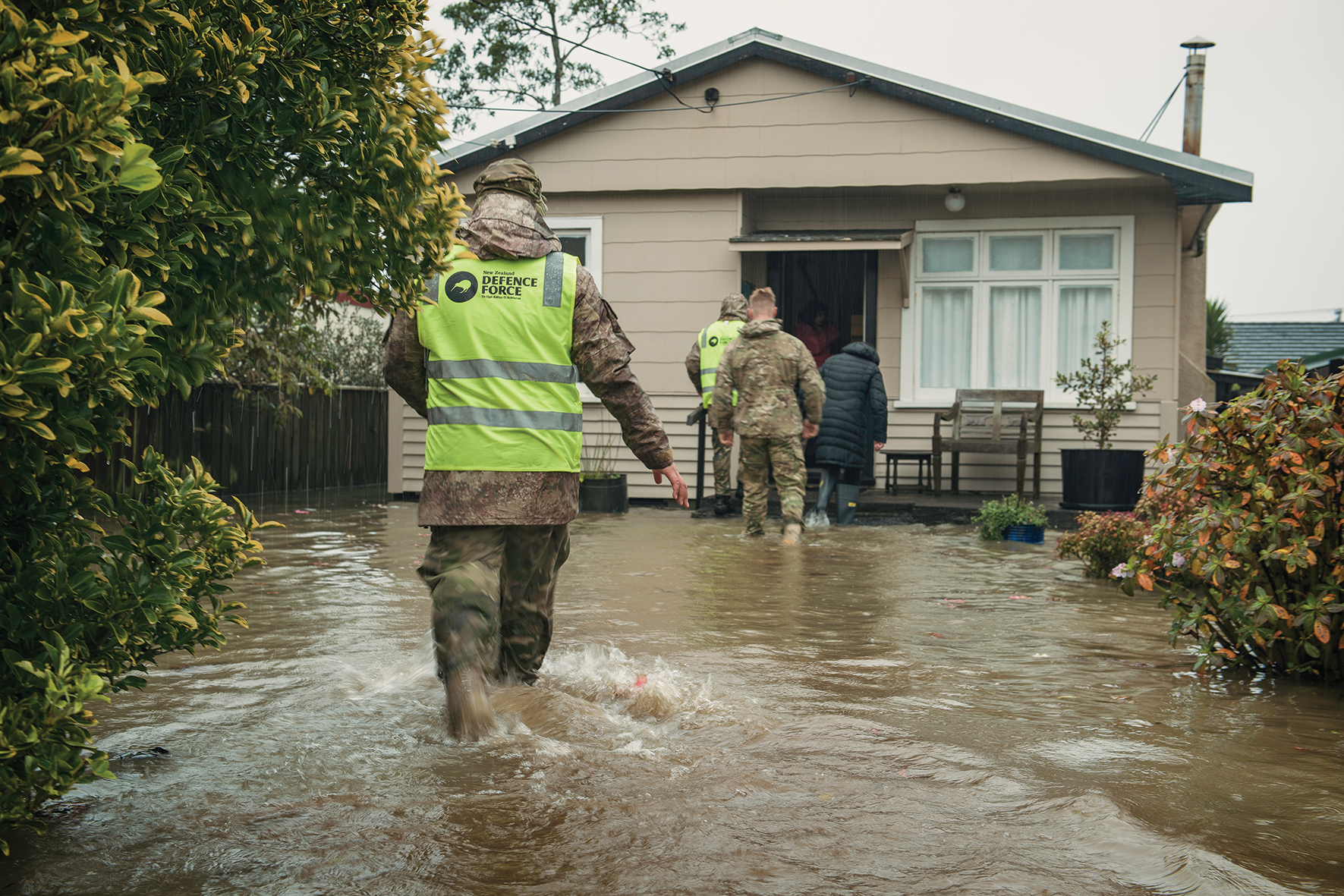
More than 2,000 residents were evacuated, and 127 houses left uninhabitable.
Dorothy’s home didn’t stand a chance. In a matter of hours, a sanctuary that housed generations was ruined.
“When we came back to the house after the waters receded, I opened my kitchen drawer where our cutlery was kept, and water just poured out of it. We’ve had weddings here, funerals, anniversaries, birthdays, you name it. That’s all gone now. It’s not a home anymore”.
Like death and taxes, floods are an inevitable part of life in New Zealand. They’re our most frequent natural hazard.
The power of water can be devastating – just half a metre of water will pick up and carry the largest of vehicles. When moving at 40km/h, 15 centimetres of water has the pressure equivalent of wind blowing at 1,270km/h.
Insurance Council figures show floods cost New Zealand a record $248 million last year.
With around two-thirds of the population living in flood-prone areas, the health, homes, and livelihoods of hundreds of thousands of New Zealanders are at risk. There are also major implications for infrastructure and the economy.
The people of Westport know this all too well. The same day that Dorothy started to hear rain start to fall, Westport’s then Civil Defence Controller Bob Dickson had been looking at forecasts from NIWA showing a monumental amount of water was on its way.
The following day he recommended a civil emergency be declared. Next came the agonising decision for mandatory evacuation.
Dickson ordered people out of their homes, pushing them to seek higher ground, stay with friends or family, even sleep in their cars if they had to. It was the right thing to do.
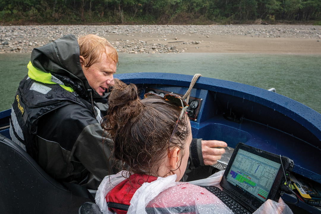
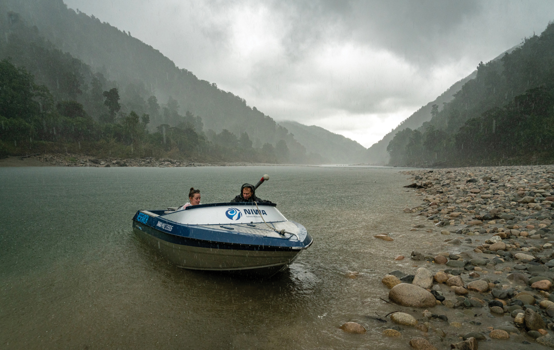
The next morning, NIWA environmental monitoring technician Mike O’Driscoll raced up the bulging Buller River in his jetboat.
Using a radar gun, he measured its water flow. A reading flashed on O'Driscoll’s screen, and he knew immediately things were bad: 7,640 cubic metres per second – the largest river flow measurement ever recorded in New Zealand.
That water was plunging down the gorge towards Westport, coinciding head-on with the high tide.
Dickson’s decision saved lives. But how did he come to it and how do you calculate flood risk?
The process for forecasting a flood hasn’t always been exact.
“Down by the Buller Bridge, there’s an old swing that we used to use. It’s got a couple of markers on it, so when water got to a certain height, we knew we were in trouble. It’s unscientific, but it helps,” says Bob.
To really help communities during these momentous events, however, we need to throw in the best that science can offer.
Flood risk is a hyper-localised measurement. Even next door neighbours can have different flood risk ratings. Predicting the precise extent, location and potential damage of floodwater takes data, a lot of data. Elevation of the land, soil type, building materials, vegetation, and proximity of people to water sources are just some of the factors that need to be considered.
In July, this information, amongst a barrage of other data points, advice, warnings, and worries, was being channelled to Dickson and the anxious, sleep-deprived team at the West Coast Regional Council.
NIWA’s national flood awareness system played a key part in helping to decipher that deluge of data.
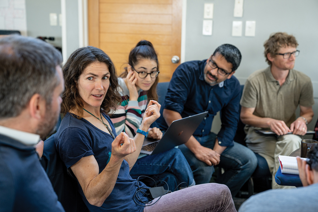
Dr Céline Cattoën-Gilbert is a hydrological forecasting scientist with NIWA. From her office in Christchurch Cattoën-Gilbert and her colleagues were helping Dickson and the regional council make calls on how to deal with the events that were unfolding.
Cattoën-Gilbert is fine-tuning a national river flow tool that combines high-resolution rainfall forecasts with detailed catchment data. The tool models flows for close to 50,000 rivers across New Zealand.
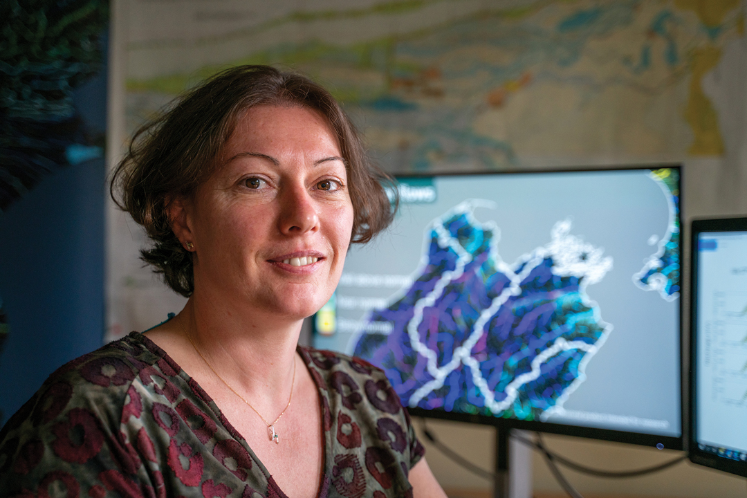
“Luckily, we had been working with the West Coast on river forecasting just a couple of months before last year’s flood. When the weather came in, we were able to provide information from real-time data about how, when and where the flood was likely to happen, giving us a high-resolution forecast up to 48 hours in advance.
“Usually, river gauges only give the town 1.5 hours notice to evacuate. We were able to help with decision making and get people out much earlier,” she says.
For Dickson and his team, it was invaluable.
“The advice we were receiving around the modelling and predictions matched, almost to the letter, what was happening on the ground. It was great science to have in our back pocket.
“It gave us peace of mind about the decision we made to keep ahead of this event and to get evacuations underway. We have quite an elderly population and people with their own unique medical problems; there is an old people’s home that we were ready to evacuate, which would have caused significant difficulties. Luckily, the modelling showed that we didn’t have to.
“This town has been through a hell of a lot. That science supporting our decision making is so critical, and working with our colleagues at NIWA and the Regional Council proved to be an absolute bonus. It’s first class,” says Dickson.
This flood forecasting work feeds into a much larger five-year, NIWA-led, multi-partner research programme to map flood hazard and risk consistently across the whole country.
Called Mā te Haumaru ō te Wai, the programme will investigate the vulnerability of communities, buildings, and infrastructure networks, along with the long-term sustainability of flood schemes and defences.
Dr Emily Lane is a hydrodynamic scientist at NIWA who specialises in natural disasters and leads the programme. She says the project will, for the first time, provide a national look at flooding hazards, risks and solutions.
“There are areas in New Zealand that have a fairly clear idea of flooding outcomes, but this isn’t the case everywhere. We have an incomplete and inconsistent picture; some places are getting left behind. Having a national-scale lens means that we can start making fair and equitable decisions,” she says.
The project is providing a forum for researchers, iwi, stakeholders, and government to investigate flood inundation hazard and risk, and to co-develop strategies for communities to use to become more flood resilient.
An important step is translating hazard into risk. Heavy rain in a flood prone area is a hazard, so at what point does this become a risk to people and places? Where is the water going to go and how bad will it get? How will different types of land, e.g., farms versus forests, impact water depths, and what could the potential damage costs be?
Lane says this kind of information is crucial for emergency responses such as those seen in Westport last year. It helps communities know who to evacuate and when. It also helps with the coordination of sending the right defences and resources to the right places. Who might need sandbags to protect their home? Where should temporary shelters be set up? How will supplies get to the people most in need?
In the longer term, it can help planners when creating new developments or changing land use. For example, if you build a new road, how might it impact where water flows during a flood?
The second part of the project is about understanding how people react to flood hazards, particularly over the long term, to assist in developing adaptation strategies.
The team at NIWA is working closely with communities to understand how they react to flood hazards.
Dr Paula Blackett, NIWA’s Principal Scientist of Environmental Social Science, heads this work.
“A lot of our emergency response practices are about the immediate aftermath and saving lives, trying to get back to the original state as quickly as you can.
“However, we don’t fully understand how floods affect people’s lives over space and time. People can be out of their houses for months, their insurance premiums are higher, they have repair costs. They can be so traumatised by an event that they don’t come back,” she says.
Lane says flood risk is all about what’s important and valuable to people, and individual responses to flooding vary widely.
“We want to understand how communities deal with it, so we are working with them to figure out what’s right for them, empowering people to make their own decisions.”
Lane says Vision Mātauranga is a major part of the project’s framework.
“Māori have spiritual connections with their land and interact with it in different ways to Pākehā. Altering nature by putting in things like stopbanks and seawalls might not fit with their worldview and what’s important to them. Including the Māori worldview is an important part of finding solutions.”
There’s also a giant elephant in the room: climate change.
Temperatures are rising, leading to a warmer atmosphere and more evaporation. The result, says Lane, is more intense storms ahead.
Before the 1970s, New Zealand was hit with just one or two big floods a year. Now, it’s about four to seven, according to the Insurance Council.
Human changes to the environment, such as deforestation and building on wetlands, often increase the intensity and frequency of flooding too.
Lane says understanding climate change is fundamental to both the modelling and mitigation.
“We now know a bit more about how climate change is playing out, so we must go back to our old data and models to adapt them. We have built flood defences to a certain level in the past. But now with climate change, the biggest flood we expected has been completely outdone.”
“We’re already seeing impacts that I thought my children were going to see. Our instincts for what floods might be like may no longer be accurate because it’s not a static climate anymore, it’s changing, it’s getting worse.”
Bob Dickson echoes her comments.
“People must adapt. We’re in a very changing situation, a fluid situation. Climate change is here. It’s real. And Mother Nature always wins.”
So, what’s next for Dorothy Burrows and her beloved town of Westport? Sadly, for Dorothy, she’s lost her family home.
“I’m not coming back here. It would be too unsettling at my age. I don’t think I could sleep at night if we got a heavy rain forecast again. I just want to get on with the rest of my life, not that I’ve got a lot of years ahead.”
It’s too late for Dorothy Burrows but Lane hopes Mā te Haumaru ō te Wai will help communities like Westport make the right decisions as the climate changes.
After all, flooding may be here to stay, but we don’t have to let it drown us.
This story forms part of Water and Atmosphere - May 2022, read more stories from this series.