PDF of this article (481 KB)


More accurate than tea leaves, a sediment core is telling the Lake Tutira Drilling Group what’s happened in the past – and what could be in store for Hawke’s Bay and New Zealand.
Given current concern about global climate change, the recognition of human influence on warming, and the forecast potential for extreme and unpredictable weather, environmental records that tell of wet, stormy, and dry seasons past are valuable tools to gauge New Zealand’s climate in coming decades. Climate records come in many forms and lengths, from hourly automated readings made throughout New Zealand, to lake and marine sediments that indirectly preserve a complex fingerprint of cycles of change over thousands of years. Storm events not only register in news headlines, but also in the deposits that are created in lakes, on floodplains, and in the ocean, when torrential rains cause landslides and swollen rivers flush large volumes of sediment downstream. Anyone who has planned a Christmas camping trip on the east coast will know that storms are common enough, and indeed, both storms and droughts form an integral part of New Zealand’s climate.
Reading the weather from mud
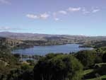
The landscape responds to seasonal climate drivers like El Niño–Southern Oscillation (ENSO), geological forces such as earthquakes and volcanic eruptions to the west, and landscape change and deforestation brought about since human settlement. Lakes can be good recorders of annual water cycles; the glacially fed lakes that border the Southern Alps are an obvious example. At Lake Tutira in the Hawke’s Bay region, rather than marking annual cycles of snow melt, greybrown mud inter-layered with black ooze records the passage of storms. Here, light-coloured layers represent influxes of detritus, washed into the lake from erosion of the surrounding hills. These storm beds alternate with quiet periods, when high biological activity produces the dark organic-rich ooze.
In March 2003, we used the Webster Drilling Company barge to recover a 26–m–long mud core from the floor of Lake Tutira (see ‘Drilling Lake Tutira for evidence of climate change’ W&A 12(2)). Our work on the core has established a record that stretches back nearly 8000 years to the time when the lake was formed by a huge landslide. Rainfall has been recorded at the nearby Tutira Homestead since 1894, and this allows us to verify the historical storm records since early settlement of the region. For older events, carbon dating and identification of ashes erupted from the Taupo volcanic region have provided a remarkably accurate calendar for the remainder of the core.
Layers from individual storms are clearly visible in the core. Since the lake’s creation, many storms the size of Cyclone Bola have left layers thicker than 20 cm. Three ‘1–in–100–year’ events recorded last century – in 1988 (Bola), 1938, and 1924 – can be corroborated with historical rainfall records. However, as other scientists have noted, the scale of landscape erosion depends on vegetation cover, implying that the scale of erosion under full forest cover before colonisation was smaller than that seen with today’s pastures. Taking a much broader view of time, we can tell from storm layer colour, thickness, and frequency that storm intensity has waxed and waned over millennial time scales. We’ve found three discernable periods of increased storminess, around 1000–1200, 1800–2000, and 3700–4300 years before the present. During these periods storms occurred about every 3–5 years.
Rainfall not only enhances erosion of the hills around the lake but also changes the biochemical environment of the lake water. Over the warmer summer months, photosynthetic organisms proliferate or ‘bloom’, contributing to the black ooze on the lake bottom. Droughts and warmer periods are represented by these sequences, broken only by very thin layers of clay from minor rainfall events. There are three relatively quiet periods around 1600, 3500, and 6000 years ago, when storms occurred only every 35 years or longer.
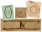
The lake water biology is also affected by storms. Diatoms, the small photosynthetic organisms preserved in abundance on the lake floor, can record eras of significant environment change. Periods of enhanced storm intensity were also periods of increased species richness from land runoff. Pollen records preserve a similar pattern and mirror vegetation changes on the surrounding hills in response to extended intervals of wetter or drier climate, along with impacts from destructive processes such as volcanic eruptions and fires.
The drivers for storms and droughts
Earlier cores showed that storm layering might be correlated to El Niño seasons. This new study extends the storm record beyond the onset of marked ENSO activity about 4000 years ago. But if the last century is some indication of climatic patterns, new analysis suggests that the relationship with ENSO activity is complex. Many of the large storms, including Cyclone Bola, occurred when El Niño was fairly weak. More clearly identifiable is the pattern of storms with enhanced easterly winds, reflecting the storm’s origin as a subtropical cyclone or depression – a situation that is more in tune with La Niña conditions.
So, was Cyclone Bola rare? These new data suggest that it was not. Droughts and storms have always been part of the Hawkes Bay climate, but global warming has the potential to accentuate this cycle and lead to events that may equal or exceed the size and duration of floods or droughts in the past 8000 years.
Looking forward by revealing climates past
What we learn about the natural rhythm of storms over the last 8000 years should help unravel the activity pattern of climate drivers from the warm regions of the Pacific (such as ENSO), or potential climate links with the Southern Ocean. The Lake Tutira core will form a template with which to compare land–ocean linkages and the record of oceanic change preserved in cores along northeastern New Zealand. And the climate story told by the the Lake Tutira core might reveal climate cycles and change over millennia that will guide planning for such events in the future.
Core truths
- A sediment core from Lake Tutira records past environmental conditions in its layers.
- The layers can be dated by correlation with a century of rainfall records, ash from volcanic eruptions, and carbon dating.
- This extensive record offers new views about past climate, and the likelihood of a stormy future.
Further reading
Eden, D.N.; Page, M.J. (1998). Palaeoclimatic implications of a storm erosion record from late Holocene lake sediments, North Island, New Zealand. Palaeogeography, Palaeoclimatology, Palaeoecology 139: 37–58.
Guthrie-Smith, H. (1999). Tutira: the story of a New Zealand sheep station. University of Washington Press. 536 p.
Lake Tutira Drilling Group. (2004). Drilling Lake Tutira for evidence of climate change. Water & Atmosphere 12(2): 12–13.
The Lake Tutira Drilling Group comprises scientists from five institutions: Dr Alan Orpin and Lisa Northcote (NIWA); Mike Page, Dr Noel Trustrum, Dr Hannah Brackley, Dr Ursula Cochran, and Dr Dallas Mildenhall (GNS Science); Dr Lionel Carter (Victoria University of Wellington); Dr Basil Gomez (Indiana State University, USA); and Dr Alan Palmer (Massey University).
Teachers’ resource for NCEA Achievement Standards or Unit Standards: Earth Science Level 2 US6362 Science Level 1 US6349 Weather Level 2 US20160 See other curriculum connections
