PDF of this article (231 KB)


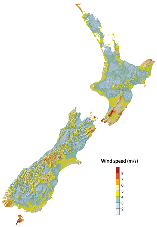

Maps of average annual wind speed and solar radiation based on climate-station data.
Andrew Tait, Ben Liley, John Sansom, and Roddy Henderson discuss how, with good quality data, we can improve our knowledge of our country’s substantial renewable energy resources.
New Zealand is fortunate in having large renewable energy resources for its population, supplying up to 70% of our electricity, and nearly a quarter of all our energy. Nevertheless, as we have seen in 2001 and 2003, abnormally low hydro-lake inflows during 'dry years' can have a significant impact on power generation and on the nation’s economy. It is clear that more diverse, sustainable, and dependable electricity generation is vital for New Zealand’s economic well-being. Most new generation will come from renewable sources, hence there is great interest in finding and evaluating the resources.
Environmental monitoring and databases
To assess the country’s renewable energy resources and identify locations where future electricity generation is most feasible, it is imperative to begin with good data. NIWA maintains the National Hydrometric and Climate Databases, which store lake and river water levels, river flows, and climatic data from all over New Zealand. The data are collected by NIWA, MetService, local and central government agencies, hydropower companies, and a very large number of volunteer observers. NIWA also collects ocean data from wave buoys, current meters, and tide gauges, and stores an ever-increasing supply of atmospheric and oceanic satellite data.
Our data resource has been built up over many years, with the earliest meteorological observations in New Zealand beginning in 1852. Long time series of data are critical, enabling us to better understand the processes which govern our temperamental weather and seas. For example, current research into the effects of climate cycles (such as El Niño/La Niña) and climate change on New Zealand’s rainfall and river flows will help electricity suppliers plan for the possibility of low inflows into hydro storage lakes.
Over the last 40 years, the number of environmental data recording sites around New Zealand has risen steadily. The number of climate stations recording hourly solar radiation data, for example, has increased from none to about 90 in this time and the number of river-flow recording sites has trebled. These increases make it possible to provide a more comprehensive picture of our renewable energy resources.
Mapping the resources
Any assessment of renewable energy availability in and around New Zealand needs to consider spatial variability. With the careful collection of ground-, water-, and satellite-based data and adherence to stringent quality control procedures, we can produce accurate maps of our renewable energy resources.
The maps shown here depict the average annual wind speed and solar radiation patterns for the whole country. They are derived from long-term climate station data, interpolated to fill in the gaps where there are no stations, and cover the country. To achieve the best accuracy, we use topographic data, the daily air temperature range, and satellite-derived cloud-cover information. It is obvious from these maps that there are favourable areas for electricity generation from these renewable resources. Maps like these can be used to select potential sites for more detailed investigation, and also to determine the suitability of regions for specific crops that could provide biomass as an energy source.
NIWA has also developed maps of mean flow and low flow in rivers, based on climate and geological data. These maps have been validated using data from existing flow recorders, and can provide estimates of the likely water resource in rivers where flow data are not available. We are linking estimates of flow with models that predict the flow necessary to protect the stream’s environmental values, so that potential electricity generation effects can be assessed before any investment is made.
Assessing the energy demand
In New Zealand homes, heating accounts for about a third of all energy use. Water heating makes up another third, with the rest used for lighting and other appliances. The ’space heating' component depends greatly on season, and of course on location. One way to quantify the need for heating is with 'heating degree days', an index based on the length of time the temperature is below an assumed comfort level – here 18°C. The total heating degree days for June to September in an average year can be used to estimate typical requirements for space heating in homes.
Summer cooling (air conditioning) is minimal in average New Zealand household power consumption, but for larger buildings it is a much greater component of energy use. Cooling degree days are calculated in the same way as heating degree days (except that the units are summed for days exceeding 18°C), and can be used to assess this load.
Mapping out our energy future
- Renewable energy resource assessments are based on reliable long-term environmental monitoring.
- Mapping allows us to locate suitable areas for direct energy extraction, suitability for biomass production, and drivers of demand.
- Long-term data are essential to understand the effects of climate variability on the renewable resources.
The effect of climate on electricity supply and demand
NIWA, the Ministry of Economic Development, and Infometrics Ltd are currently studying the impact of climate (specifically heating and cooling degree days) on the electricity demand of major cities around New Zealand, and the subsequent flow-on effects on the nation’s economy.
Short-term variations in the climate (such as cold snaps lasting about five days) can result in a significant drain on the electricity supply. Averaged over the year and aggregated nationally, however, the climate signal is effectively washed out of any variations in electricity demand; the principal drivers are the level of economic activity (for example, GDP) and electricity price. Year-to-year changes in hydro-lake inflows, caused by variability in rainfall and snowmelt, are also being studied in relation to electricity supply.
It is becoming clear that large-scale climatic cycles (such as the El Niño Southern Oscillation and the Interdecadal Pacific Oscillation), as well as long-term climate changes, can have a significant effect on lake inflows, hydropower generation, and our economy. This highlights the need for alternative renewable energy generation capability in New Zealand.
Dr Andrew Tait and Dr John Sansom study climate variability and are based at NIWA in Wellington. Ben Liley works at NIWA in Lauder on atmospheric processes affecting solar radiation; Roddy Henderson, based at NIWA in Christchurch, studies catchment processes and water resources.
Teachers’ resource for NCEA AS: Science 90191 (1.6); Mathematics 90193 (1.5). See other curriculum connections at www.niwa.co.nz/pubs/wa/resources