PDF of this article (229 KB)

New Zealand is blessed with an abundant wind resource. Steve Reid explains how it is measured and modelled.
The largest recent changes in New Zealand’s renewable energy supplies have been in the field of wind energy. Arrays of turning wind turbines are no longer an unusual sight, and will become increasingly common. New Zealand enjoys many advantages in the wind-energy resource: an oceanic location, long mountain chains aligned to intercept the prevailing westerly wind flow, large gaps (such as Cook Strait and the Manawatu Gorge) to channel the flow, and hills that increase the wind speed. These features all serve to create a high quality wind resource (see the wind resource map).
Winds in New Zealand
Interactions between the wind and the land lead to a variety of interesting phenomena with different scales that need to be considered while developing the resource.
- Microscale – timescale of a few minutes and spatial scale of up to 1 km, affecting individual turbines. Motions on this scale are chiefly turbulent and irregular, and affect the choice of location for individual turbines and the stresses on them.
- Mesoscale – a few hours and up to 100 km, affecting wind farms. There are complex interactions between the wind, moisture, temperature, and pressure on this scale: the stability of the atmosphere is important for many of the phenomena. Variations on this scale determine the availability of the wind resource and are important for scheduling and integrating the variable generation into the national grid. For example, as weather fronts approach a wind farm, the energy output can increase rapidly as the winds build up, and a situation may develop where there is no energy output because the turbines shut down (for protection) in very high winds. Mesoscale weather models can be used to accurately forecast the wind variations.
- Seasonal scale – weeks to months, affecting regions and the whole country. The seasonal wind climate and variations driven by El Niño/La Niña cycles will affect the resource, with El Niño generally favouring increased southwesterly winds and above average resource and La Niña resulting in lower resource.
- Climate change – over decades, affecting the planet. Current projections indicate an increase in the westerly component of the wind for the next century or two, with a corresponding increase in the wind resource for New Zealand.
Modelling and predicting the wind
The use of computers to model the atmosphere has led to spectacular improvements over the last 20 years in the detailed understanding of wind flow over terrain and to improved forecast accuracy. At present, NIWA is implementing an accurate and reliable high-resolution numerical weather forecast model for the New Zealand region that takes full advantage of including in situ, hydrological, and high-resolution satellite observations. The system is able to forecast winds on the weather-system scale and through much of the mesoscale, and uses the parallel processing power of the NIWA supercomputer. Winds can be forecast on the scale of wind farms.
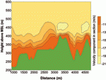
Challenges remain in the modelling of the atmosphere at scales below 10 km because models representing all of New Zealand have very large computing requirements. Modelling a local area is possible, and excellent progress has been made in the microscale by simulating individual eddies (see 'Microscale modelling around Wellington' below). Progress has also been made with models that parameterise (represent, rather than detail) the eddy motions, including the stability effects that are very important in the mesoscale. The yellow and green diagram shows the velocity from one such model and demonstrates how the flow varies over a hilly area with a hydraulic jump (a downstream 'wall' or ridge) just to the left of the highest point.
Assessing the wind resource
Detailed wind assessments at specific sites are carried out by making wind measurements for 1-2 years and comparing these to the nearest long-term climate station as a reference. NIWA has considerable experience installing and operating portable wind masts. These masts usually combine anemometers at various heights with data loggers from Unidata (our manufacturing plant in Perth) and electronically transfer the data back to NIWA.
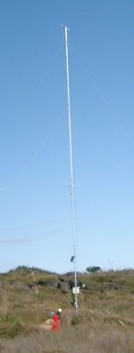
In recent years, more permanent lattice masts have been used to a greater extent. Installations can take a number of forms, including the standard 30-m mast shown at left .
New instrumentation
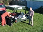
NIWA has developed a SODAR (SOund Detection And Ranging – similar to radar) instrument for surveying wind energy sites. It has been deployed at three sites of interest for wind energy, including Tararua wind farm. Since then, it has been upgraded for more portable operation by mounting it on a trailer and removing the need for mains power. The SODAR replaces the need to shift instrumented masts around potential wind-farm sites.
In trials, the upgraded SODAR performed well in acoustically quiet places, providing wind velocity profiles up to heights over 700 m. Although wind noise can be a problem, careful siting allows data to be gathered for large proportions of the time.
Catch the wind
- Potential wind-energy sites can be assessed using on-site measurements, with anemometers complemented by SODAR.
- High-resolution models can indicate preferred sites for individual turbines.
- Wind forecasts can help optimise the capture of the resource and warn of large fluctuations in output.
Microscale modelling around Wellington
By combining a digital terrain model and a high-resolution, time-dependent, fluid-flow solver, we can estimate peak wind speeds and their frequency. A terrain model of Baring Head (at the entrance to Wellington Harbour) and the adaptive flow solver Gerris, developed at NIWA, have been combined to produce the results illustrated here.
The terrain is coloured according to the instantaneous wind speed, with high wind speeds depicted in red. Acceleration over the ridges of the Rimutaka Range is clearly visible (in red) as well as the sheltering in the valleys (blue). The streamlines illustrate the complex flow separation and turbulent recirculation occurring in the lee of ridges.
Modelling with this level of detail can be used to site turbines to optimise wind capture and minimise the effects of turbulence and wind shear.
Dr Steve Reid’s studies include meteorology, modelling, and wind energy; he is based at NIWA in Wellington. Dr Stephane Popinet prepared the material in the box on microscale modellng; he is also with NIWA in Wellington.
Teachers’ resource for NCEA AS: Science 90191 (1.6), 90313 (2.2); Geography 90207 (1.6). See other curriculum connections at www.niwa.co.nz/pubs/wa/resources
