Climate developments in Febuary 2007

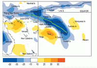
The South Pacific Convergence Zone (SPCZ) was located further south of its normal location in February, with enhanced convection extending from the region northeast of Vanuatu, southeast to southern French Polynesia, including Fiji, Tonga, Niue, and the Southern Cook Islands. Another region of enhanced convection existed north of the Solomon Islands. The Inter-Tropical Convergence Zone (ITCZ) was less active than in previous months north of the equator. A region of suppressed convection and low rainfall existed north of the SPCZ, centred over the Northern Cook Islands, extending over Tokelau and Eastern Kiribati, and also toward northern French Polynesia.
February rainfall was 25% or less of normal in the Northern Cook Islands, Tokelau, and parts of Northern French Polynesia. Rainfall was also low, being 50% or less of normal in much of New Caledonia. In contrast, rainfall was above average (at least 150% of normal) in parts of Western Kiribati and Tuvalu, and at least 125% of normal throughout much of Fiji. Flood producing rainfall occurred in parts of Fiji, some locations recording approximately 100 mm or more, on February 2nd, 3rd, and 9th; Labasa recording 272 mm within 24 hours during that period.
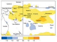
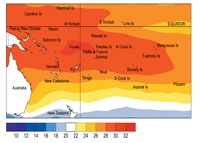
February mean air temperatures were about 1.0 °C above average in parts of French Polynesia, and 0.5 °C above average in New Caledonia. New Caledonia recorded its first warmer than normal month in the past six months.
Tropical Southwest Pacific mean sea-level pressures were well above average in the South Tasman Sea, extending ridges of high pressure toward New Caledonia. Pressures tended to be below average in equatorial areas well east of the Date Line, and near average elsewhere in the Southwest Pacific. Equatorial surface westerlies occurred in only 1% of observations at Tarawa, the lowest frequency since April 2006.
| Country | Location | Rainfall (mm) | % of average | Comments |
|---|---|---|---|---|
| Tonga | Salote Airport | 23 | 12 | Record low |
| French Polynesia | Hiva Hoa, Atuona | 36 | 23 | Well below normal |
| New Caledonia | La Tontouta | 23 | 17 | Well below normal |
Soil moisture in Febuary 2007

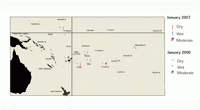
Estimates of soil moisture shown in the map (right) are based on monthly rainfall for one station in each country. Currently there are not many sites in the water balance model. It is planned to include more stations in the future.
The information displayed is based on a simple water balance technique to determine soil moisture levels. Addition of moisture to available water already in the soil comes from rainfall with losses via evapotranspiration. Monthly rainfall and evapotranspiration are used to determine the soil moisture level and its changes.
Please note that these soil moisture calculations are made at the end of the month. For practical purposes, generalisations were made about the available water capacity of the soils at each site.
At the end of February 2007, Tarawa, Nadi, Hanan, and Rarotongan soils were at field capacity (full).
El Niño/Southern Oscillation (ENSO)


El Niño conditions in the tropical Pacific diminished quickly during February, and sea surface temperature anomalies across the equatorial Pacific declined steadily.
The NINO3 and NINO4 anomalies were +0.2°C and +0.6°C respectively in February (down from +1.2°C and +0.9°C in January), with the respective Dec–Jan–Feb 3–month means +1.0°C and +0.9°C. The decrease in the warm anomalies were due in part to the resurgence of easterly trade winds moving colder surface waters westwards, and contributing to the rapid eastwards movement of a cold sub-surface (up to 4°C below average at 75m at 110°E) anomaly into the eastern equatorial Pacific.
The sub-surface warming, seen in recent months, has all but disappeared in the eastern Pacific, and has been replaced by an extensive cold water anomaly between 75 and 175m across the equatorial Pacifi c east of the Date Line. However, in the western Pacific (just east of the Date Line), a small but shrinking patch of sub-surface warm water still lingers.
The Southern Oscillation Index (SOI) increased to -0.5 in February (up from -1.0 in January) with a 3 month mean of -0.6.
OLR and tropical rainfall anomalies for February indicate enhanced convection west of the Date Line, on the SPCZ at about 175°E, along the North Pacific arm of the ITCZ, and in the Indian Ocean.
The Madden-Julian Oscillation (MJO) is presently weak, and is passing across Indonesia with increased convection. The MJO is expected to continue to propagate eastwards bringing a return to drier conditions/suppressed convection to Indonesia and northern Australia, and a weakening of SPCZ activity by the middle of March when the MJO crosses the Date Line.
Most ENSO models show neutral states for the next 6–9 months. Many of the models have not been able to capture the speed at which El Niño diminished over the last two months. The NCEP CFS and the NASA-NSIPP models predict a possible transition from neutral to La Niña within the next 3–6 months.
The IRI synthesis of a large set of dynamical and statistical models, as well as observations of the ocean surface and sub-surface gives a probability of a La Niña over the next few months at 30%, while the chance of El Niño continuing has dropped to 10%. Neutral conditions are the most likely outcome at 60%.
Forecast validation: December 2006 to Febuary 2007
Suppressed convection with below average rainfall was expected over New Caledonia and Fiji, with average or below average rainfall affecting Papua New Guinea, Vanuatu, Tonga, Niue, the southern Cook Islands, and the Tuamotu and Marquesas Islands. A large region of enhanced convection and above average rainfall was expected over Western and Eastern Kiribati, Tuvalu, and Tokelau, with areas of near or above average rainfall over the Solomon Islands, Wallis and Futuna, Samoa, the Northern Cook Islands, and also Pitcairn Island. Near average rainfall was forecast for the Austral and Society Islands.
A large region of enhanced convection and/or above average rainfall affected Nauru and Western Kiribati, extending east, north of the equator (within the ITCZ Zone). Suppressed convection and/or below average rainfall occurred in the Coral Sea and over New Caledonia, as well as Niue, the Northern Cook Islands, and Northern French Polynesia. Rainfall was lower than expected in Eastern Kiribati, and higher than expected in Fiji, and the Society Islands. The ‘hit’ rate for the December 2006 – February 2007 outlook was just under 60%.
